monsoons

2021 average daily rainfall June, July August.
The Indian summer monsoon, also known as the southwest monsoon, falls within the South Asian monsoon and is the strongest and perhaps best-known of the world’s monsoons. During summer months when the Asian landmass heats up, warm, moist air flows northward from the Indian Ocean towards the Himalayas, bringing abundant showers and thundershowers to India. The summer monsoon is a regular event that occurs every year and is responsible for roughly 80% of India’s annual rainfall. The summer monsoon typically starts in early June, peaks in July and August and winds down during September and early

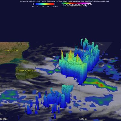
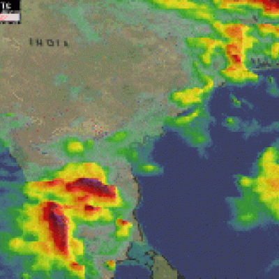
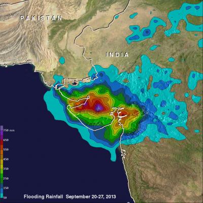
GPM Captures Monsoon Rains Bringing Flooding to India

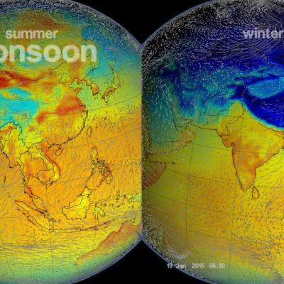
The summer monsoon is a regular feature this time of year in India, and it can bring heavy rains to the region. However, periodically areas of low pressure can form within the general monsoon trough and bring even more rain. Although the extreme Himalayan topography located to the north is much more well-known, another contributing factor to the heavy rains along the southwest coast of India is the Western Ghats. Though much smaller than the Himalayas, this mountain range runs parallel to the West Coast of India with many peaks over 2,000 meters (~6,500 feet). As a result, the Western Ghats

India's Deadly Monsoon Rainfall Measured With GPM IMERG

India's southwest monsoon (summer rainy season) normally occurs between June and September. This year's monsoon has been assessed as average but India's Meteorological Department statistics show that daily mean rainfall for the country has recently been above normal. At least 15 people were killed by floods and landslides in India on Wednesday July 11, 2018. So far this year, close to 200 deaths may have resulted from India's heavy monsoon rainfall. These estimates of rainfall accumulation were constructed using data from NASA's Integrated Multi-satellitE Retrievals for GPM (IMERG). Algorithms

GPM Sees Powerful Storms With Advancing Monsoon

The GPM core observatory satellite passed over the Bay Of Bengal on May 23, 2017 at 0251 UTC. GPM flew almost directly above very strong convective storms that were located east of Sri Lanka. These powerful storms were associated with the approaching South-West monsoon. The amount and timing of monsoon rainfall is very important to the economy of India. GPM's Microwave Imager (GMI) and Dual-Frequency Precipitation Radar (DPR) instruments collected data that showed the location and intensity of rainfall in the southern Bay Of Bengal. Very heavy rainfall was detected within this cluster of

Monsoons: Wet, Dry, Repeat

Submitted by JacobAdmin on Thu, 06/23/2016
Video Embed

The monsoon is a seasonal rain and wind pattern that occurs over South Asia (among other places). Through NASA satellites and models we can see the monsoon patterns like never before. 

Monsoon rains provide important reservoirs of water that sustain human activities like agriculture and supports the natural environment through replenishment of aquifers. However, too much rainfall routinely causes disasters in the region, including flooding of the major rivers and landslides in areas of steep topography.

Monsoons: Wet, Dry, Repeat
Credit: NASA/Goddard/Ryan Fitzgibbons This video is public domain and along with other supporting visualizations can be downloaded from the Scientific Visualization Studio The monsoon is a seasonal rain and wind pattern that occurs over South Asia (among other places). Through NASA satellites and models we can see the monsoon patterns like never before. Monsoon rains provide important reservoirs of water that sustain human activities like agriculture and supports the natural environment through replenishment of aquifers. However, too much rainfall routinely causes disasters in the region...

IMERG Sees Onset Of Possibly Wetter India Monsoon

On June 8 the nodal weather agency of India (IMD) declared the arrival of the 2016 Southwest Monsoon over the Indian state of Kerala. This season is expected to be rainier than recent years. The El Nino conditions which have been blamed for recent disappointing monsoons has weakened to ENSO-neutral conditions. ENSO-neutral conditions are expected to transition to La Nina in the northern hemisphere by the fall and winter of 2016-17. La Nina conditions normally result in beneficial wetter and cooler monsoons in India. An animation of weekly rainfall totals was derived from NASA's Integrated

India's Monsoon Starts

Monsoon rainfall, although a little later than normal, has started in southern India. Due to El Nino conditions India's monsoon is predicted to bring below normal rainfall this year. Cooling rainfall comes to the country after high temperatures preceding the monsoon have caused the reported deaths of over 2300 people. Data from the NASA's Integrated Multi-satellitE Retrievals for GPM (IMERG) was used in this animation to show the advent of India's monsoon. Rainfall estimates for the past few days (4-5 June 2015) show that some heavy showers have dropped over 120mm (4.7 inches) of rain in the

Western India's Intense Monsoon Rain

Western India has been having intense monsoon rainfall since September 21, 2013. This has resulted in widespread flooding in the west Indian state of Gujarat and reports of at least three related deaths. India had record breaking flooding in the northern state of Uttarakhand in June 2013 with more than 6,000 people killed. Near real-time TRMM Merged HQ/Infrared Precipitation (3B42) data were used in the rainfall analysis above. Rainfall total estimates from these space satellite data for the seven day period from September 20-27, 2013 were used. The highest totals of almost 800mm (~31.5 inches

Extreme India Monsoon Rainfall Analyzed

Extreme, sometimes disastrous, monsoon rainfall has occurred so far over India during June and July 2013. The image above shows rainfall total estimates from space satellite data for the seven day period ending on June 17, 2013. Near real-time TRMM Merged HQ/Infrared Precipitation (3B42) data, with seven days totals, were analyzed for the period from June 14-July 25, 2013. These rainfall estimates are shown in simulated 3-D perspective views with higher precipitation amounts appearing to be taller than lower amounts. Rainfall totals were also color enhanced with lower amounts being assigned