
IMERG Sees Heavy Rainfall in Central America from Eta and Iota
The record-breaking 2020 Atlantic hurricane season, aided by the ongoing La Niña, is officially the most active Atlantic hurricane season on record, surpassing the 2005 season in the total number of named storms with 30 to date. Incredibly, the latest storm Iota wasn’t just another named storm, but a powerful Category 5 hurricane and the strongest storm of the season. It was also only the 2nd Category 5 storm to occur in the month of November on record, the other being in 1932. The warm waters of the Caribbean continue to serve as a breeding ground for late-season storms this season. Iota became the 5th storm and 4th hurricane to form in the Caribbean since the start of October, following Tropical Storm Gamma and Hurricanes Delta, Zeta, and Eta. And just like most of those storms, Iota began as a westward propagating easterly wave moving through the Caribbean.
Iota formed into a tropical depression (TD) the morning of Friday November 13 in the central Caribbean, about midway between the western tip of Haiti and the northern coast of Columbia. Later that same afternoon, the depression was upgraded to a minimal tropical storm and given the name Iota. Despite the warm waters and moist environment - conditions ideal for strengthening - Iota was kept in check by wind shear (environmental winds that vary with direction and/or intensity at different levels in the atmosphere and tend to pull tropical systems apart) induced by an upper-level low off to the west, and was still a minimal tropical storm the next morning on the 14th. However, as the upper low moved away and weakened, the wind shear relaxed, allowing Iota to strengthen throughout the afternoon, and by 1:00 am EST in the early morning of the 15th, the National Hurricane Center (NHC) reported that Iota had become a hurricane and was continuing to rapidly strengthen. Iota’s central pressure continued to fall throughout the day on the 15th, then began to fall even more sharply later in the evening, so that just after midnight NHC reported that Iota’s maximum sustained winds had reached 125 mph, making it a Category 3 hurricane. However, Iota’s rapid intensification continued on, and by 10 am EST on the morning of the 16th, Iota’s central pressure had plunged to 917 mb (27.08 inches of mercury) with sustained winds reported by NHC at 160 mph, making Iota a very powerful Category 5 hurricane and the strongest hurricane of the season. By now, Iota’s center was just 100 miles east of the coast of Nicaragua and moving due west. Iota maintained its extreme intensity until 10 pm EST that evening, when the peak sustained winds weakened slightly to 155 mph as the center neared the coast of Nicaragua. Iota made landfall soon after at 10:45 pm EST as a high-end Category 4 storm with maximum sustained winds reported at 155 mph by NHC near Haulover on the northeast coast of Nicaragua about 15 miles from where powerful Hurricane Eta, also a Category 4 storm at the time, made landfall earlier in the month. Iota rapidly weakened as the center continued westward across Central America through northern Nicaragua, southern Honduras, and into El Salvador where it where finally dissipated.
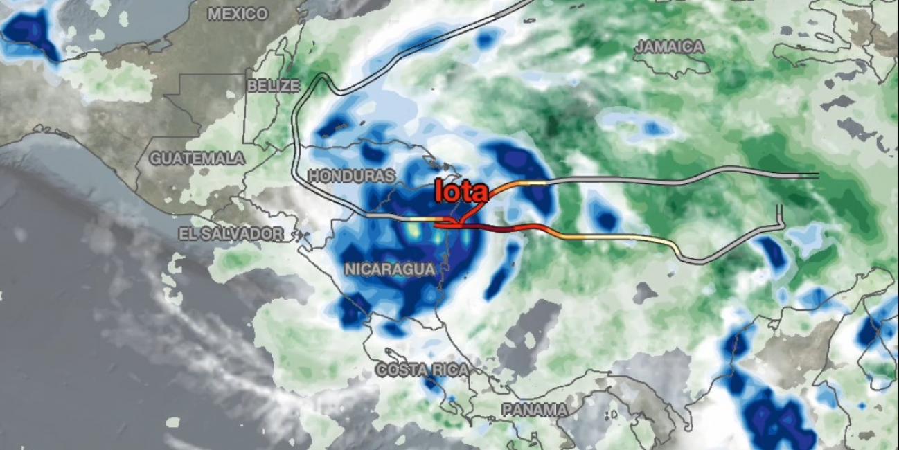
NASA combined data from multiple satellites in the GPM Constellation to estimate the rainfall from Hurricanes Eta and Iota in near real-time at half-hourly intervals from November 1 - 18, 2020. The above animation shows rainfall rates (blue/yellow shading) and total rainfall accumulations (green shading) from NASA's IMERG algorithm, overlaid on shades of white/gray, indicating clouds from NOAA infrared satellite data. The multi-colored line shows the hurricane’s tracks based on NHC advisories, with orange, red, and dark red indicating hurricane categories 3, 4, and 5 respectively.
IMERG estimated that rainfall accumulations over parts of Nicaragua and Honduras were already in excess of 12 inches after Eta’s passage on November 6. Eta continued on a meandering course, alternating between tropical depression and tropical storm strength, as it dumped additional rainfall over Cuba and South Florida. Iota made landfall at nearly the same location as Eta, but continued westward as it weakened over the complex topography of Central America. By Nov. 18, 2020, Iota was classified as a remnant low pressure system as it exited the Central American landmass over El Salvador.
IMERG estimates indicate the combined rainfall accumulations from Eta and Iota exceeded 24 inches over a small part of Nicaragua, while many parts of Belize, Guatemala, and Honduras received over 12 inches.
Credits:
Story by Steve Lang and Jason West (NASA GSFC)
Animation by Jason West (NASA GSFC)