

Typhoon Vongfong Hits the Philippines
The first typhoon of the season, Vongfong, struck the central Philippines this past week (where it is known as Ambo) as a strong category 2 storm, bringing strong winds and locally heavy rainfall. Vongfong formed into a tropical depression in the southern Philippine Sea west of Palau on Sunday May 10th from a disturbance that had been slowly making its way westward over the past several days. After becoming a depression, the system moved northward toward the central Philippine Sea and slowly began to intensify. Then, on the 12th when it reached tropical storm intensity, Vongfong’s northward movement was slowed in response to a ridge of high pressure to the north, and the storm turned westward in the direction of the central Philippines. As is approached the central Philippines, Vongfong responded to the warm sea surface temperatures in the area and began to rapidly intensify, reaching category 3 intensity on the morning of the 14th (local time) and its peak intensity with sustained winds estimated at 120 mph by the Joint Typhoon Warning Center. At this point the center of Vongfong was very near to the coast of the Philippines island of Samar. Fortunately, Vongfong weakened slightly becoming a category 2 storm before making landfall around 12:15 pm (local time) at San Policarpo on the northeast coast of Samar. After crossing Samar, Vongfong began to weaken and turned northward as it made its way through the central Philippines before passing over the main island of Luzon and back out to sea in the direction of Taiwan as a tropical depression.
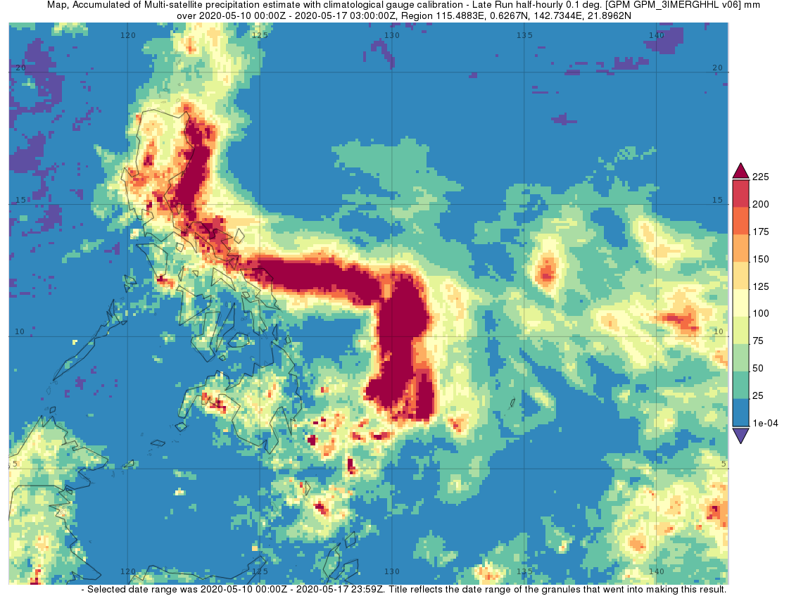
Surface rainfall accumulations (mm) estimated from the NASA IMERG satellite precipitation product from 10 to 17 May 2020 in association with the passage of Typhoon Vongfong. Image from NASA GSFC using IMERG data archived at https://giovanni.gsfc.nasa.gov/giovanni/. This image was produced with the Giovanni online data system, developed and maintained by the NASA GES DISC.
As it made its way through the central and northern Philippines, Vongfong brought locally heavy rains to the region. IMERG, the Integrated Multi-satellitE Retrievals for GPM, is a unified satellite precipitation product produced by NASA to estimate surface precipitation over most of the globe. With IMERG, precipitation estimates from the GPM core satellite are used to calibrate precipitation estimates from microwave and IR sensors on other satellites to produce half-hourly precipitation maps at 0.1o horizontal resolution. Shown here are IMERG surface rainfall accumulations for the period 10 to 17 May 2020 for the Philippines and the surrounding region in association with the passage of Vongfong. Vongfong’s heaviest rains occurred off shore over the central Philippine Sea where the cyclone slowed before turning west. Nevertheless, Vongfong still brought locally heavy rainfall on the order of 200 mm (~8 inches, shown in red) or more to the northern half of Samar where it made landfall as well as to southern, far eastern and isolated parts of central Luzon. Nearly all of the main island of Luzon received at least 100 mm (~4 inches, shown in yellow) of rain. So far, Vongfong is being blamed for at least 4 fatalities in the Philippines.
Text by Steve Lang (NASA GSFC)