

Celebrating Earth Day with GPM
On April 22, 2020, people around the world will celebrate the 50th anniversary of Earth Day, embracing our commitment towards understanding the planet’s environmental processes and protecting it for future generations. In support of this global event, NASA is highlighting the agency’s contributions to the environment with a week of online events, stories, and resources. Check out these activities at NASA’s Earth Day 2020 site.
50 Years of Earth Day
It’s been five decades since Apollo 8 astronaut William Anders photographed Earth peaking over the Moon’s horizon. The iconic image, dubbed Earthrise, inspired a new appreciation of the fragility of our place in the universe. Two years later, Earth Day was born to honor our home planet. As the world prepares to commemorate the 50th anniversary of Earth Day, NASA reflects on how the continued growth of its fleet of Earth-observing satellites has sharpened our view of the planet’s climate, atmosphere, land, polar regions and oceans.
To view the full data visualizations that appear throughout, go to: https://www.youtube.com/playlist?list...
En español: https://www.youtube.com/watch?v=k96DO...
This video is public domain and along with other supporting visualizations can be downloaded from NASA Goddard's Scientific Visualization Studio at: https://svs.gsfc.nasa.gov/13586
Along with these contributions, NASA’s Global Precipitation Measurment mission (GPM) is providing multiple resources to demonstrate how GPM precipitation data-based products support efforts to help sustain and improve Earth’s environment and have a positive effect globally for people throughout the world. You will learn through visualizations, blogs, and educational lessons how end users (an individual who uses satellite data) uses GPM data to make decisions and policies that help benefit society.
The GPM team provides a peek into the roles of two unique end users, Faisal Hossain (a professor from University of Washington) and Iker Llabres (an actuary scientist), and how each along with their organizations contribute to conserving freshwater resources and building climate resilience against natural hazards throughout the world.
Applications of GPM Precipitation Data
Satellite Data Used to Empower Small Holder Farmers in Pakistan and India
Agriculture in Pakistan is dependent on irrigation from the Indus River. But over the years, these freshwater resources have become scarce. Today, it is one of the world’s most depleted basins. To tackle this, farmers are attempting to predict and track freshwater resources with the help of NASA satellites and cell phones.
This video is public domain and along with other supporting visualizations can be downloaded from NASA Goddard's Scientific Visualization Studio at: https://svs.gsfc.nasa.gov/13592
While many farmers in India depend on groundwater, canal water and rainwater as primary sources of irrigation, uncertainties in weather and irrigation water supplies and lack of reliable information on farm water requirements is resulting in inefficient watering practices consequently making farming unsustainable and contributing to India’s water-scarcity issue. A UW CEE research team led by CEE professor Faisal Hossain has developed a technology-based irrigation advisory system to enable small farmers to receive irrigation information directly to their cellphones. This is called the PANI (Provision of Advisory for Necessary Irrigation) system. This application uses NASA Earth observations, such as precipitation data from the GPM mission, to help farmers make effective decisions to save water and make agriculture a more sustainable practice in India.
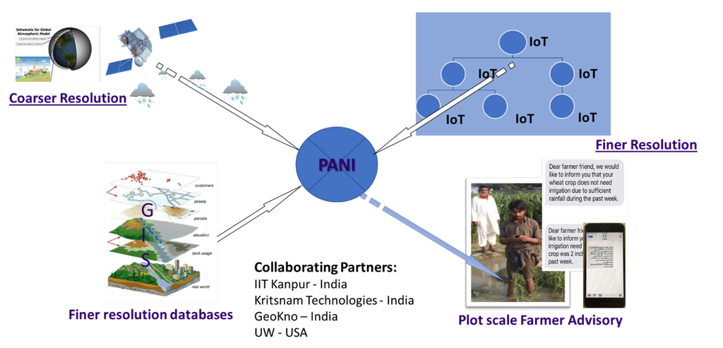
The PANI concept, combining satellite and weather model data (upper left) with finer resolution geographic data (lower left) and personalized farm data (upper right) to generate irrigation advisories in real-time via cellphones. Credits: PANI Team and Faisal Hossain.
Building Climate Resilience with Satellite Data
Unexpected shocks from natural hazards can affect populations throughout the globe, threatening sustainable development and resilience. However, the impacts of these events, such as extreme precipitation or drought, disproportionately affect the developing world where individuals often are not insured and live and work in conditions that leave them vulnerable to natural disasters. This can lead to significant economic and environmental challenges if preventive measures or mitigating measures are not taken in time. To reduce risks from natural disasters and build climate resilience, decision makers are using NASA Earth observations to develop index-based insurance products and protect low-income customers in Central America.
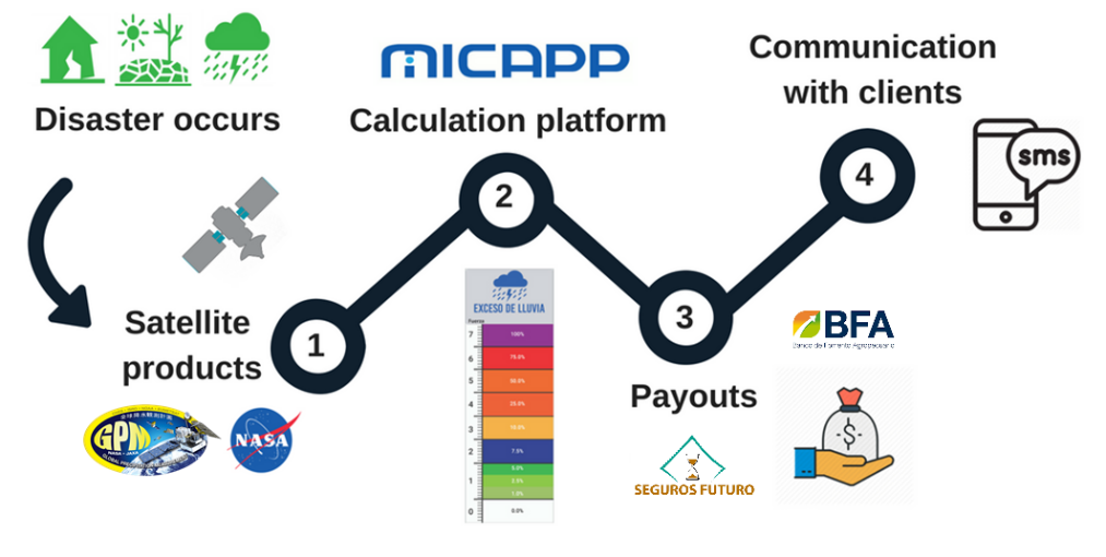 MiCRO’s payout process depicting actions taken when a disaster strikes: NASA satellite data (1) is used to design payout triggers through a calculation platform (2). When a disaster occurs and depending on its severity, payment is determined (3) and clients are informed via text (4). Credits: MICRO
Precipitation Education Lesson Plans
Water for Wheaties? Freshwater Resources for Agriculture
Using a Project-based approach, students will learn about Earth’s freshwater resources and how NASA’s Earth observing satellites are helping us better understand Earth’s water. They will work in small “expert groups” to explore growing wheat; the differences in weather and climate in two wheat farming regions of the world, Pakistan and Kansas; and the scarcity of freshwater resources in Pakistan. Using this information, students will get into “expert teams” and work with NASA data from the GPM mission to explore the amount of precipitation that has fallen in these two regions over the past two decades. They will make recommendations for how farmers in Pakistan could reduce their water usage based on the work that is being done by Faisal Hossain. In the upper grade level lessons, they will also learn how small farmers are able to obtain low cost insurance which uses GPM data to determine whether a payoff is indicated. Finally, they will consider ways they can reduce their use of freshwater resources in their own lives.
Each lesson plan is aligned to NGSS for the grade level band, and increase in complexity both conceptually and through the evaluation component. Lessons plans include a variety of resources; including a Teacher’s Guide, a PowerPoint presentation, an evaluation rubric, a student note-taking organizer, and several other resources to help guide the students to work collaboratively in Project Teams.
Lesson Plan Links: