TRMM News

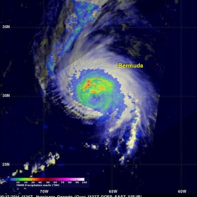
Rainfall From Hurricane Fay and Gonzalo

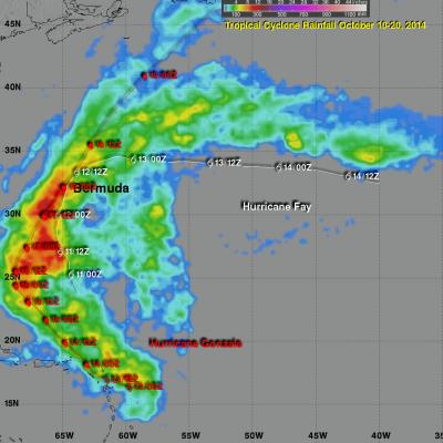
Hurricane Fay battered Bermuda on October 12, 2014. The following Friday powerful Hurricane Gonzalo passed directly over the island on Friday October 17, 2014 causing flooding and damage to many structures. The remnants of Gonzalo also pounded the British Islands with winds exceeding 70 mph causing the death of at least one person. This image shows an analysis of rainfall around Fay and Gonzalo as they moved through the central Atlantic Ocean and over Bermuda. The analysis was based on near real time TRMM-based precipitation estimates (TMPA) that were produced by merging data from several

Powerful Hurricane Gonzalo Menacing Bermuda

Hurricane Gonzalo formed south-southeast of Puerto Rico on October 12, 2014 and was upgraded to a hurricane the following day. Gonzalo became increasingly more powerful and was a weakening category four hurricane on the Saffir-Simpson hurricane intensity scale with sustained winds of about 115 kts (132 mph) when viewed by the TRMM satellite on October 17,2014 at 1335 UTC (10:35 AM ADT). A rainfall analysis from TRMM's Microwave Imager (TMI) is shown here blended with a GOES-EAST visible/infrared image received a few minutes later at 1337 UTC(10:33 AM ADT). A large area of heavy rainfall was

Ana Threatens Hawaiian Islands

Tropical storm Ana, that formed southeast of the Hawaiian islands on October 13, 2014, will be the third tropical cyclone to threaten the island chain this year. Hurricane Iselle weakened to a tropical storm and passed over the island of Hawaii on August 8, 2014. Hurricane Julio was still a hurricane when it veered to the northeast of the islands on August 10, 2014. Tropical storm Ana was recently seen by the TRMM satellite on October 16, 2014 at 2224 UTC and October 17, 2014 at 1313 UTC. Rainfall from these two orbits are shown overlaid on GOES-WEST visible and infrared images received on the

Cyclone Hudhud Makes Landfall, Brings Potential for Heavy Rains to Himalayas

Cyclone Hudhud, which reached the equivalent of a category 4 hurricane on the US Saffir-Simpson scale over the Bay of Bengal, weakened slightly before making landfall Sunday morning (local time) on the central southeast coast of India near the port city of Visakhapatnam. Hudhud came ashore with wind gusts of up to 120 mph and so far is being blamed for 24 fatalities in India. The TRMM-based, near-real time Multi-satellite Precipitation data (TMPA) analysis is used to monitor rainfall over the global Tropics. A TMPA rainfall analsis for the period 7-14 October 2014 over India and the

TRMM Sees Intensifying Cyclone Hudhud

The TRMM satellite flew over intensifying cyclone Hudhud in the Bay Of Bengal on October 10, 2014 at 0945 UTC.A Rainfall analysis from TRMM's Microwave Imager (TMI) instrument and Hudud's track is shown here. Cyclone Hudhud's is predicted to become a powerful category three tropical cyclone (on the Saffir-Simpson hurricane scale) with sustained winds peaking at 100 kts (115 mph) before hitting India's east coast in a couple days.

Widespread Rainfall With Super Typhoon Vongfong

Vongfong was a super typhoon with wind maximum sustained winds of 145 kts (167 mph) when the TRMM satellite flew over on October 8, 2014 at 2328 UTC. Vongfong was the most powerful typhoon since super typhoon Haiyan that killed over 6,000 people after hitting the Philippines in November 2013. In the first image TRMM's Microwave Imager (TMI) shows that Vongfong was producing rainfall over a large area with heavy rainfall revealed in the eye wall and in multiple feeder bands. The small animation shows typhoon Vongfong's rainfall being overlaid on a MTSAT Visible/Infrared image. The Joint Typhoon

Typhoon Vongfong

Typhoon Vongfong formed on October 2, 2014 southeast of Guam. Typhoon Phanfone, that recently pummeled Japan, formed near the same area in the western Pacific Ocean. Vongfong had wind speeds of about 120 kts (138 mph) when the TRMM satellite flew above the intensifying typhoon's eye on October 7, 2014 at 0800 UTC. TRMM's Precipitation Radar (PR) showed that powerful storms in Vongfong's eye wall were producing very heavy rainfall. TRMM's Microwave Imager (TMI) show that multiple rain bands spiraling into Vongfong were also dropping rain over a large area. Vongfong is predicted by the Joint

Typhoon Phanfone Batters And Soaks Japan

Phanfone was a powerful super typhoon with sustained wind speed estimated at 130 kts ( 150 mph) as it approached Japan but had weakened to a category one typhoon with sustained winds of about 70 kts (81 mph) as is passed near Tokyo. Phanfone's track and locations when the tropical cyclone was near Japan are shown overlaid in white. The TRMM- based, near-real time Multi-satellite Precipitation Analysis (TMPA) at the NASA Goddard Space Flight Center has been measuring the distribution of precipitation over the tropics. TMPA based rainfall totals are shown here for the period from September 28 to

Powerful Typhoon Phanfone

Typhoon Phanfone had sustained wind speeds of about 110 kts (127 mph) and a well defined eye when the TRMM satellite passed over on October 3, 2014 at 0208 UTC. Microwave Imager (TMI) and Precipitation Radar (PR) measurements showed that Phanfone's eye wall and strong feeder bands contained rain frequently falling at a rate of over 60 mm (2.4 inches) per hour. Typhoon Phanfone's wind speeds were predicted today by the Joint Typhoon Warning Center (JTWC) to peak at 120 kts (138 mph) on October 4, 2014 0600 UTC. As a weakening typhoon, Phanfone's course is predicted to change from north

Typhoon Phanfone Becomes More Powerful

The TRMM satellite again flew over typhoon Phanfone in the western Pacific Ocean on October 2, 2014 at 0939 UTC. Typhoon Phanfone's estimated sustained wind speeds had increased to over 115 kts (about 132 mph). The rainfall pattern observed using TRMM's Microwave Imager (TMI) and Precipitation Radar (PR) data showed that Phanfone was much better organized than a day earlier. This precipitation analysis revealed that intensifying typhoon Phanfone had a large eye. The heaviest rainfall was shown falling at a rate of over 50 mm (almost 2 inches) per hour in the northern side of the typhoon's eye