TRMM News

Typhoon Phanfone Heads Toward Japan

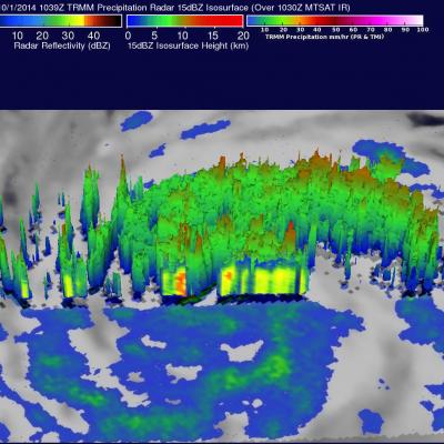
An intensifying typhoon called Phanfone that originated east of Guam on September 28, 2014 is headed toward southern Japan. The TRMM satellite crossed above typhoon Phanfone on October 1, 2014 at 1039 UTC. Rainfall that was made from TRMM's Microwave Imager (TMI) Precipitation Radar (PR) data collected with this orbit is shown in this image. Typhoon Phanfone's winds were estimated to be above 65 kts (about 75 mph) at the time of this TRMM view. Winds within the increasingly powerful typhoon are are expected to increase to over 100 kts (115 mph) in the next few days while moving toward the

Tropical Storm Rachel

Tropical depression 18E, located southwest of Mexico, became tropical storm Rachel on September 24, 2014 at 1500 UTC (8 PM PDT). The TRMM satellite had a good view of Rachel when it flew over early today at 0608 UTC (September 25, 2014 at 11:08 PM PDT). A precipitation analysis that used TRMM's Microwave Imager (TMI) data is shown overlaid on a 0600Z GOES-WEST enhanced infrared image. This image shows that, due to northeasterly wind shear, convective precipitation was located southwest of of Rachel's center of circulation. The heaviest rain was shown falling at a rate of over 50mm (amost 2

Tropical Depression 18E Forms

Tropical cyclones have continued to form in the eastern Pacific Ocean at a faster rate than last year. This morning at 8 AM PDT (1500 UTC) a low pressure center south of Mexico was upgraded to a tropical depression (18E). The TRMM satellite crossed over the forming tropical depression on September 23, 2014 at 0729 UTC (00:20 AM PDT). TRMM's Precipitation Radar (PR) instrument found that rain was falling at a rate of almost 61 mm (2.4 inches) per hour near the low's center of circulation. Radar reflectivity values of over 51 dBZ were analyzed in some heavy showers by TRMM PR. This simulated 3-D

Hurricane Odile Rainfall Totals

During the past week hurricane Odile and remnants have produced heavy rainfall that caused dangerous flooding over the Baja California peninsula and the southwestern United States. Rainfall from Odile may be welcomed in the Southwest where some areas have been experiencing extreme to exceptional drought conditions. The Tropical Rainfall Measuring Mission or TRMM satellite was launched in November 1997 with the primary mission of measuring rainfall in the Tropics using a combination of passive microwave and active radar sensors. The rainfall analysis above was made using real-time TRMM Multi

Hurricane Edouard Headed for Cooler Waters

Edouard, which became the fifth named storm of the season after forming on the night of September 11th (EDT) west of the Cape Verde Islands, continued to strengthen as it made its way through the central Atlantic this past week, reaching hurricane intensity on the 14th before becoming the first major hurricane of the season when it peaked briefly as a category 3 storm on the 16th with sustained winds reported at 100 knots (~115 mph) by the National Hurricane Center (NHC). Fortunately, the storm has not posed a threat to the US East Coast due to the presence of a deep-layer trough along the

Baja California Battered And Drenched By Odile

Category three hurricane Odile caused widespread destruction after hitting Baja California on Sunday night. Odile had weakened to a tropical storm with winds of about 55 kts ( 63.3 mph) when the TRMM satellite flew over on September 16, 2014 at 0917 UTC (2:19 AM PDT). Odile was still well organized and TRMM's Precipitation Radar (PR) measured rain falling at a rate of almost 130 mm (5.1 inches) per hour northeast of the tropical storms's center of circulation. The tops of some strong thunderstorms over the Gulf Of California were reaching heights of 13km (8 miles) and returning radar

Hurricane Odile Strikes Baja California

The TRMM satellite passed directly above hurricane Odile on September 15, 2014 at 0344 UTC. This was about an hour before the strong Hurricane hit Baja California near Cabo San Lucas at around 0445 UTC (September 14, 2014 9:45 PM PDT). The National Hurricane Center (NHC) hurricane discussion on September 15, 2014 said, "The estimated intensity of 110 kt at landfall ties Odile with Olivia (1967) as the strongest hurricane to make landfall in the satellite era in the state of Baja California Sur". The image above shows rainfall derived from TRMM's Precipitation Radar (PR) and Microwave Imager

Tropical Storm Edouard forms in the Atlantic

The formation of Tropical Storm Edouard in the central Atlantic marks the climatological peak of the Atlantic hurricane season in what has so far been a rather average season in terms of the number of storms. Edouard became the fifth named storm of the season after forming overnight in the central Atlantic about 1645 km (~1020 miles) west of the Cape Verde Islands. In a typical season there are about 10 named storms and 6 hurricanes. So far this year, halfway through the season, there have been 5 named storms and 3 hurricanes, but none have posed a major threat to the US, and there have been

Tropical Storm Odile Forms

The hurricane season continues to be active in the eastern Pacific Ocean. Hurricane Norbert dissipated a few days ago and then tropical storm Odile formed yesterday (September 10, 2014) in the same area where Norbert formed. The TRMM satellite flew over tropical storm Odile on September 11, 2014 at 0418 UTC and collected data used in the images above. The first image shows a rainfall analysis made from TRMM's Microwave Imager (TMI) and Precipitation Radar (PR) data overlaid on a 0430 UTC GOES-WEST enhanced infrared image. TRMM PR found that Odile was dropping rain at the extreme rate of over

Moisture From Norbert Spreads Heavy Rain Over Southwest

The TRMM satellite flew above the post-tropical cyclone remnants of former hurricane Norbert on September 8, 2014 at 0849 UTC (1:49 AM PDT). This image shows TRMM rainfall derived from the Microwave Imager (TMI) and Precipitation Radar (PR) instruments overlaid on a 0900 UTC GOES-EAST enhanced Infrared image. These data show that only a small amount of light to moderate rainfall was located around Norbert's center of circulation. This view shows that heavy rainfall was being produced over the southwestern United States. This 3-D image was made from TRMM Precipitation Radar (PR) data. It shows