TRMM News

Norbert & Dolly Rain On Both Mexican Coasts

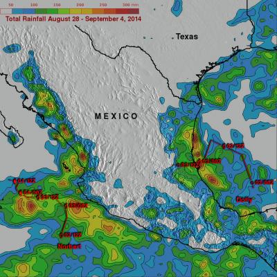
Tropical storm Dolly dissipated quickly after coming ashore yesterday in eastern Mexico but dropped heavy rain in some areas near the Gulf coast. At the same time tropical storm Norbert was approaching from the west and contributing to rainfall near Mexico's Pacific coast. TRMM-based, near-real time Multi-satellite Precipitation Analysis (MPA) data for the period from August 28 to September 4, 2014 were used in the analysis shown above. The approximate past locations of the tropical cyclones at 0000Z and 1200Z are shown overlaid in red on this analysis. The heaviest rainfall totals were found

Tropical Storm Dolly Hits Eastern Mexico

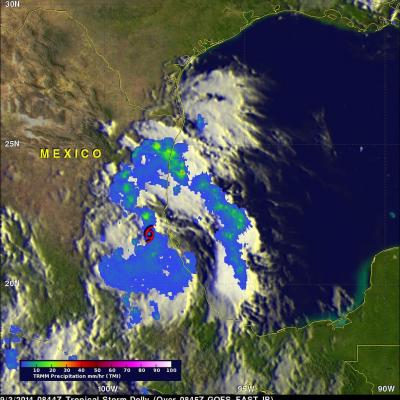
Tropical storm Dolly is dissipating after coming ashore in eastern Mexico late yesterday evening. The TRMM satellite flew over tropical storm Dolly early on September 3, 2014 at 0844 UTC ( 3:33 AM CTD) providing data used in the image above. TRMM's Microwave Imager (TMI) collected with that orbit showed that Dolly was dropping light to moderate rainfall near the dissipating storm's center of circulation. Moderate to heavy rainfall, falling at a rate of over 30 mm ( about 1.2 inches) per hour, was shown in a strong band of showers moving ashore north of Dolly's center. The TRMM satellite had a

Cristobal Passes Northwest Of Bermuda

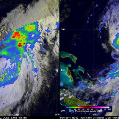
The TRMM satellite had a very good view of Cristobal on August 28, 2014 at 1258 UTC (8:58 EDT) as the hurricane passed well to the northwest of Bermuda. Rainfall derived from TRMM's Microwave Imager (TMI) and Precipitation Radar (PR) data is shown overlaid on a 1300 UTC GOES-EAST Visible/Infrared image. TRMM PR found some intense thunderstorms producing rain at a rate of almost 78 mm (about 3.1 inches) per hour in a band of precipitation feeding into Cristobal's southeastern side. The next image is a simulated 3-D view (from the west) of Cristobal's rainfall structure using radar reflectivity

Hurricane Cristobal Poised to Head Out to Sea

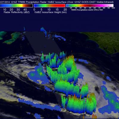
Cristobal, still a minimal Category 1 hurricane on the US Saffir-Simpson scale, has been slowly making its way northward up from the southeastern Bahamas on a track generally parallel to the eastern seaboard. The storm now appears poised to recurve away from the US East Coast and head for the central Atlantic as it begins to feel the effects of an approaching shortwave trough embedded in the westerlies that's moving eastward out of the Great Lakes region. TRMM made an overpass of Cristobal this morning, which is shown in this image taken at 12:16 UTC (8:16 am EST) 27 August 2014. At the time

Cristobal Becomes A Hurricane

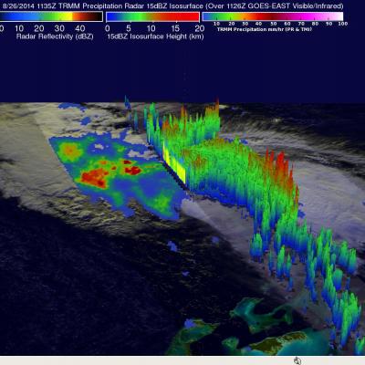
Tropical storm Cristobal was upgraded to a hurricane yesterday evening at 8:20 PM (August 26, 2014 at 0020 UTC). The TRMM satellite flew above the newly designated hurricane this morning at 1135 UTC (7:35 AM EDT) providing rainfall data used in this image. A rainfall analysis derived from TRMM's Microwave Imager (TMI) and Precipitation Radar (PR) data is shown overlaid on a 1126 UTC GOES-EAST Visible/Infrared image. Cristobal was a category one hurricane with sustained winds estimated to be slightly above 65 kts (about 75 mph) with this view. Cristobal's didn't have a clearly defined eye with

Deadly Tropical Storm Cristobal

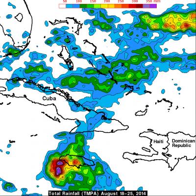
Strong winds and flooding associated with tropical storm Cristobal have caused deaths in the Dominican Republic, Haiti and Jamaica. Rainfall data for the first image above was captured by the TRMM satellite on August 24, 2014 at 1150Z (7:50 AM EDT). Tropical depression four was upgraded to tropical storm Cristobal a short time after that TRMM view. The next image uses data received by TRMM a day later on August 25, 2014 at 1230 UTC ( 8:30 AM EDT). Cristobal was a sheared tropical cyclone with a rain free center so a red tropical storm symbol was used to clarify the location of Cristobal's

Active Eastern & Central Pacific Hurricane Season

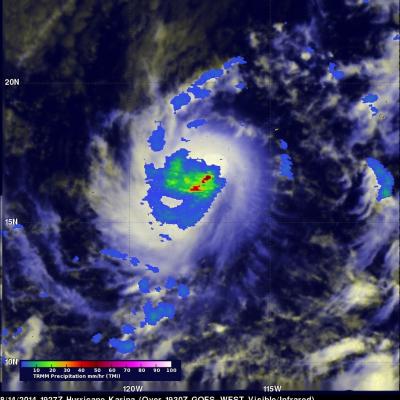
Tropical cyclones are frequently forming during this active hurricane season in the eastern and central Pacific ocean. As hurricane Julio was fading in the central Pacific Ocean north of Hawaii, hurricane Karina was forming on August 13, 2013 off the Mexican coast. The TRMM satellite passed directly above the center of intensifying tropical storm Karina on August 14, 2014 at 1927 UTC. A rainfall analysis that used data from TRMM's Microwave Imager (TMI) is shown overlaid on a GOES-WEST image received at 1930 UTC. TRMM TMI showed that storms near Karina's center were dropping rain at a rate of

Tropical Storm Iselle Departs Hawaii While Julio Stays Well North

Iselle was once a rather powerful category 4 hurricane in the East Pacific with sustained winds estimated at 120 knots (~138 mph) by the National Hurricane Center. Fortunately, a combination of southwesterly wind shear, drier air and cooler waters weakened Iselle considerably as it approached the Hawaiian Islands. Although much weaker, Iselle still struck the southeast Kau coast of the Big Island of Hawaii as a rather strong tropical storm. In fact Iselle, was the strongest and only the 2nd tropical storm to hit the Big Island in over 50 years. The center made landfall around 2:30 am HST

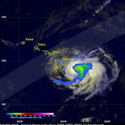
Tropical Storm Iselle Hits Hawaii

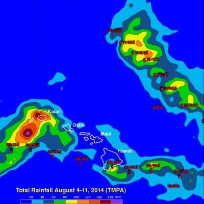
Hurricane Iselle weakened to a tropical storm while approaching the island of Hawaii on Thursday August 7, 2014. As a tropical storm Iselle contained some heavy rain showers and strong winds when it hit the big island. Iselle later dropped some heavy rain over Maui and scattered showers extended to Kauai and Oahu. The TRMM satellite had an excellent view of tropical storm Iselle as it neared the Hawaiian islands on August 8, 2014 at 0152 UTC ( August 7 at 3:52 PM HST). A rainfall analysis from TRMM's Microwave Imager (TMI) and Precipitation Radar (PR) instruments is shown overlaid on a 0200

TRMM Sees Iselle and Julio Menacing Hawaii

The TRMM satellite saw both weakening hurricane Iselle and category two hurricane Julio in the same orbit as they were moving toward the Hawaiian islands on August 7, 2014 at 0922Z. This image shows data collected by TRMM's Microwave Imager (TMI) instrument with the orbit containing both hurricanes located in the center of the image. Microwave brightness temperatures at 85.5 GHZ and at 37.0 GHZ were combined in the red, green and blue components to construct the image. Recent forecasts of tracks for hurricane Julio and tropical storm Iselle are shown overlaid in white and red respectively.