Bopha

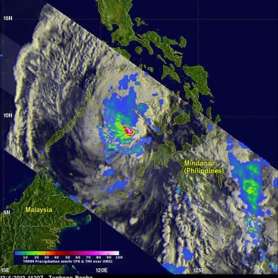
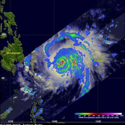
Typhoon Bopha's Heavy Rain Over Mindanao

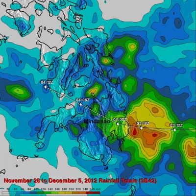
High winds, flooding and landslides from heavy rains with typhoon Bopha have caused over 300 deaths in the southern Philippines. The Tropical Rainfall Measuring Mission (TRMM) satellite's primary mission is the of measurement of rainfall in the Tropics. The TRMM-based, near-real time Multi-satellite Precipitation Analysis (MPA) at the NASA Goddard Space Flight Center monitors rainfall over the global Tropics. MPA rainfall totals are shown here for the period from November 28 to December 5, 2012 when typhoon Bopha was moving through the southern Philippines. Typhoon Bopha's track is shown

Typhoon Bopha Devastates Mindanao, Moves Into Sulu Sea

Typhoon Bopha pounded the Philippines with high winds and drenching rain when it crossed the island of Mindanao today. Numerous deaths and wide spread destruction have been reported. The TRMM satellite had a good view of Bopha moving into the Sulu Sea when it flew over on December 4, 2012 at 1420 UTC. This TRMM pass showed that Bopha still had good organization but Mindanao's rugged terrain had taken it's toll. Bopha's eye had been disrupted but TRMM Precipitation Radar (PR) data revealed that very heavy rain was still falling at a rate of over 85 mm/hr (~3.5 inches) near the center of the

Typhoon Bopha Threatens Philippines

At 0347 UTC today the TRMM satellite flew above a dangerous typhoon in the western Pacific Ocean called Bopha that is a threat to the Philippines. Bopha is predicted by the Joint Typhoon Warning Center (JTWC) to hit the island of Mindinao in the Philippines with winds of 135 kts (155 mph) later today. The first image shows a satellite view of typhoon Bofa with rainfall from TRMM's Microwave Imager (TMI) and Precipitation Radar (PR) instruments overlaid on a visible/infrared image from TRMM's Visible and InfraRed Scanner (VIRS). This analysis shows that Bopha had a well defined eye with very