Caribbean

GPM IMERG Measures Hurricane Dorian's Rainfall from the Caribbean to Canada

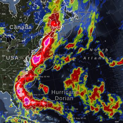
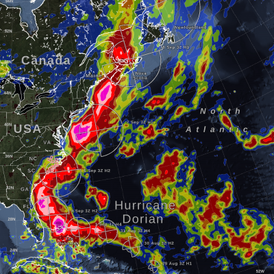
Hurricane Dorian (2019) brought heavy rain to the Caribbean, along the US East Coast, and up to Canada. NASA satellite-based precipitation estimates tracked the storm throughout its lifetime, as shown by the sequence of images below. September 3, 2019: Hurricane Dorian over Grand Bahama and Abaco Islands In the early hours of Tuesday, September 3, Hurricane Dorian had been stationary over the island of Grand Bahama for 18 hours, most of the time as a category 5 hurricane. Storm-total rain accumulation over parts of Grand Bahama and Abaco islands have exceeded 24 inches according to NASA
IMERG Measures Rainfall in Hurricane Dorian
UPDATE 9/9/19: On Monday morning, September 9, Hurricane Dorian was a post-tropical storm after a mid-latitude weather front and cold seas had altered its tropical characteristics over the weekend. On Saturday and Sunday, Hurricane Dorian struck eastern Canada, causing wind damage and bringing heavy rainfall. According to the Associated Press, a peak of 400,000 people were without power in Nova Scotia, Canada, because of Dorian. This graphic shows precipitation that fell during the almost two-week period from August 27 to the early hours of September 9. The near-realtime rain estimates come...

GPM IMERG Measures Rainfall Accumulation from Hurricane Dorian in the Caribbean

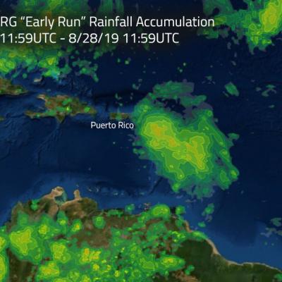
Hurricane Dorian is packing heavy rain as it moves toward the Bahamas as predicted by NOAA’s NHC or National Hurricane Center. NASA's GPM mission recently analyzed the storm and found heavy rainfall in the storm as it passed through the Caribbean. This image shows estimated rainfall accumulations for the region affected by Hurricane Dorian over the 24 hour period of Aug.27 11:59 UTC to Aug. 28 11:59 UTC. The imagery was generated using the Integrated Multi-satEllite Retrievals for GPM (IMERG) “early run” product. The data indicates that up to 120 mm (4.72 inches) of rainfall accumulated in

Heavy Rainfall In The Caribbean Measured By IMERG

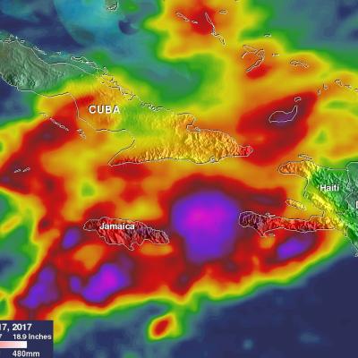
Heavy rainfall has recently caused widespread flooding and landslides in Jamaica. Occasional showers from trade winds are normal in Jamaica but recent rainfall from slow moving troughs have been unusually heavy. A 1009 mb low pressure center located in the western Caribbean was disrupting the normal trade winds over Jamaica today. This rainfall analysis was constructed using data from NASA's Integrated Multi-satelliE Retrievals for GPM (IMERG). Data collected in near-real time were utilized in IMERG's rainfall accumulation estimates for the Caribbean. This analysis covers the period from May

Deadly Hurricane Matthew's Total Rainfall

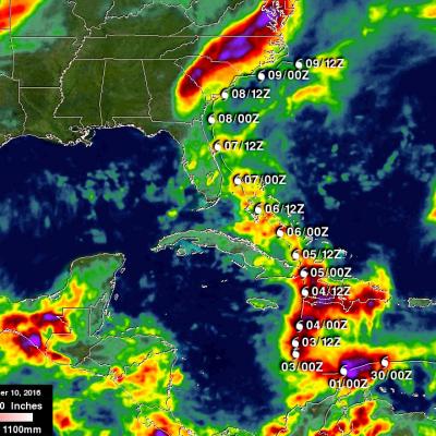
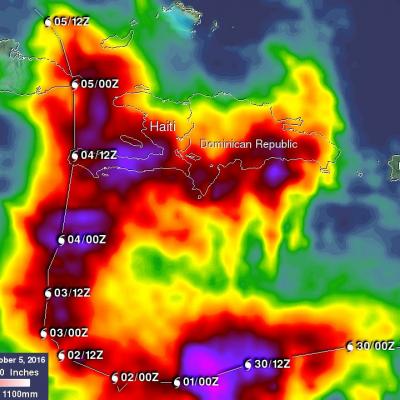
Hurricane Matthew devastated western Haiti and killed over 1,000 people. Matthew also took the lives of at least 37 deaths in the United States with 18 deaths occurring in the state of North Carolina. Flooding is still widespread in North Carolina. Some rivers in North Carolina such as the Tar and the Neuse are still rising. This rainfall analysis was accomplished using data from NASA's Integrated Multi-satelliE Retrievals for GPM (IMERG). IMERG is a unified U.S. algorithm that provides a multi-satellite precipitation product. IMERG is run twice in near-real time with the “Early” multi

Matthew Brings Heavy Rains, Destruction to Parts of the Northern Caribbean

Matthew began as a fairly impressive tropical wave that emerged off of the coast of Africa on the 23rd of September but had to make its way all the way across the Central Atlantic before finally organizing into a tropical storm on the morning of the 28th while passing through the Windward Islands. Matthew then slowly but steadily intensified into a minimal hurricane by the early afternoon of the following day as it continued to track westward through the central eastern Caribbean. The next day, September 30th, Matthew underwent a period of rapid intensification; its winds increased in

GPM Sees Hurricane Matthew Producing Dangerous Rainfall

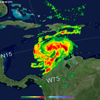
The GPM core observatory satellite passed above hurricane Matthew on October 2, 2016 at 5:46 AM EDT (0946 UTC). GPM’s Microwave Imager (GMI) and Dual-Frequency Precipitation Radar (DPR) instruments collected data that were used in the rainfall map shown here. GPM found that very heavy rainfall was located around Matthew. Rain was revealed by GPM falling at a rate of over 6.4 inches (163 mm) in some areas near hurricane Matthew. Of particular interest is an area of very heavy rain located well to the east of Hurricane Matthew’s center. This blob of strong convective storms has been persistent

GPM Finds Intense Rainfall In Matthew Rainband

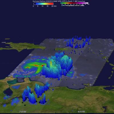
Matthew rapidly intensified Thursday evening and winds increased to 100 kts (115 mph) by Friday September 30, 2016. The GPM core observatory satellite flew over Hurricane Matthew on September 20, 2016 at 0946Z (5:46 AM EDT). A rainfall analysis from GPM's Microwave Imager (GMI) and Dual-Frequency Precipitation Radar (DPR) showed that the Matthew had heavy rainfall in the northern side of the newly formed eye wall. GPM’s radar area of coverage (shown in a higher shade) included a very intense feeder band on the southeastern side of the hurricane. DPR measured rain falling at a rate of greater

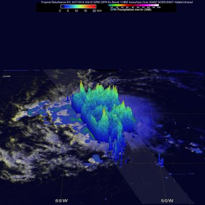
Tropical Storm Matthew Forms Over the Windward Isles, Enters the Caribbean

A fairly strong tropical wave that had been making its way westward across the Central Atlantic over the past several days has now finally organized itself into a tropical storm, Tropical Storm Matthew, the 13th named storm of the season, while passing through the Windward Islands. The storm is poised to intensify as it enters the eastern Caribbean. The tropical wave leading to Matthew's formation emerged off of the coast of Africa back on the 23rd of September. However, despite having a robust level of convective thunderstorm activity, the wave did not acquire a closed low-level circulation

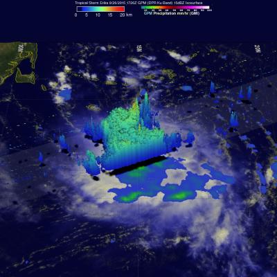
Tropical Storm Erika Enters the Caribbean

Tropical Storm Erika, the 5th named storm of the season, entered the northeast Caribbean early this morning as it passed through the Leeward Islands between Guadeloupe and Antigua. Fortunately, there were no reports of damage thanks in part to the effects of inhibiting wind shear, which kept the storm from strengthening. Erika originated as a wave of low pressure that was first detected on Friday the 21st of August midway between the West Coast of Africa and the Cape Verde Islands. The wave then tracked westward across the tropical mid Atlantic where it eventually intensified enough to become