China

Super Typhoon Rammasun Strikes the Southern Coast of China

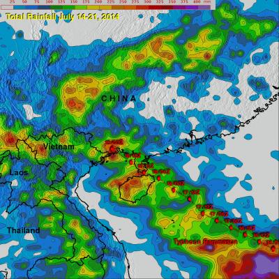
Super typhoon Rammasun struck the southern coast of China on Friday July 18th as a very powerful super typhoon with sustained winds estimated at 135 knots (~155 mph or equivalent to a Category 5 hurricane on the US Saffir-Simpson scale), making it the strongest typhoon to hit the area in several decades. Rammasun made landfall at 3:30 pm (local time) on Hainan Island where the southern half of the intense eye wall raked across the northeast tip of that island. The center then quickly cut across the Qiongzhou Strait separating Hainan from the Leizhou Peninsula to the north. The right half of

Deadly Typhoon Usagi Hits Southern China

The most powerful typhoon of 2013 hit southern China with reported winds of 95.6 kts (~110 mph) killing at least 20 people. The TRMM satellite had a fairly good view on September 22, 2013 at 0923 UTC as typhoon USAGI's eye was very near the coast of southern China. TRMM's Microwave Imager (TMI) and Precipitation Radar (PR) instruments showed that in addition to the extreme winds reported there were areas just south of USAGI's eye where rain was falling at a rate of over 169mm/hr (~6.7 inches). TRMM sliced through USAGI and found that heights of storms within USAGI were reaching only about 12km

TRMM Sees Powerful Typhoon Utor As It Neared China

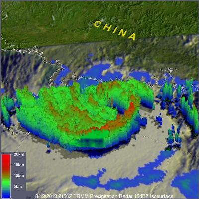
Torrential rain and powerful winds accompanied typhoon Utor when it came ashore in southern China's Guangdong province. The TRMM satellite flew above as typhoon Utor was headed toward southern China on August 13, 2013 at 2156 UTC. At the time of this TRMM pass typhoon Utor was a powerful typhoon with wind speeds reaching over 85kts (~98mph). A rainfall analysis from TRMM's Microwave Imager (TMI) and Precipitation Radar (PR) instruments is shown overlaid on an infrared image from TRMM's Visible and InfraRed Scanner (VIRS). Bands of intense rainfall are shown spiraling into the eye that was

Tropical Storm Cimaron Brings Beneficial Rain To China

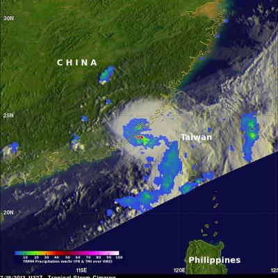
The image on the left used data captured by the TRMM satellite when it passed above tropical storm Cimaron on July 18, 2013 at 1132 UTC (~7:32 PM Local) just before it hit southeastern China. Rainfall was measured by TRMM's Microwave Imager (TMI) and Precipitation Radar (PR) instruments to be falling at a rate of over 183mm/hr (~7.2 inches) in a small area near Cimaron's center of circulation. TRMM PR found some radar reflectivity values greater than 55dBZ in these heavy rainshowers. Cimaron's track took it to the south of Taiwan yesterday. The rainfall anomaly analysis on the right was made
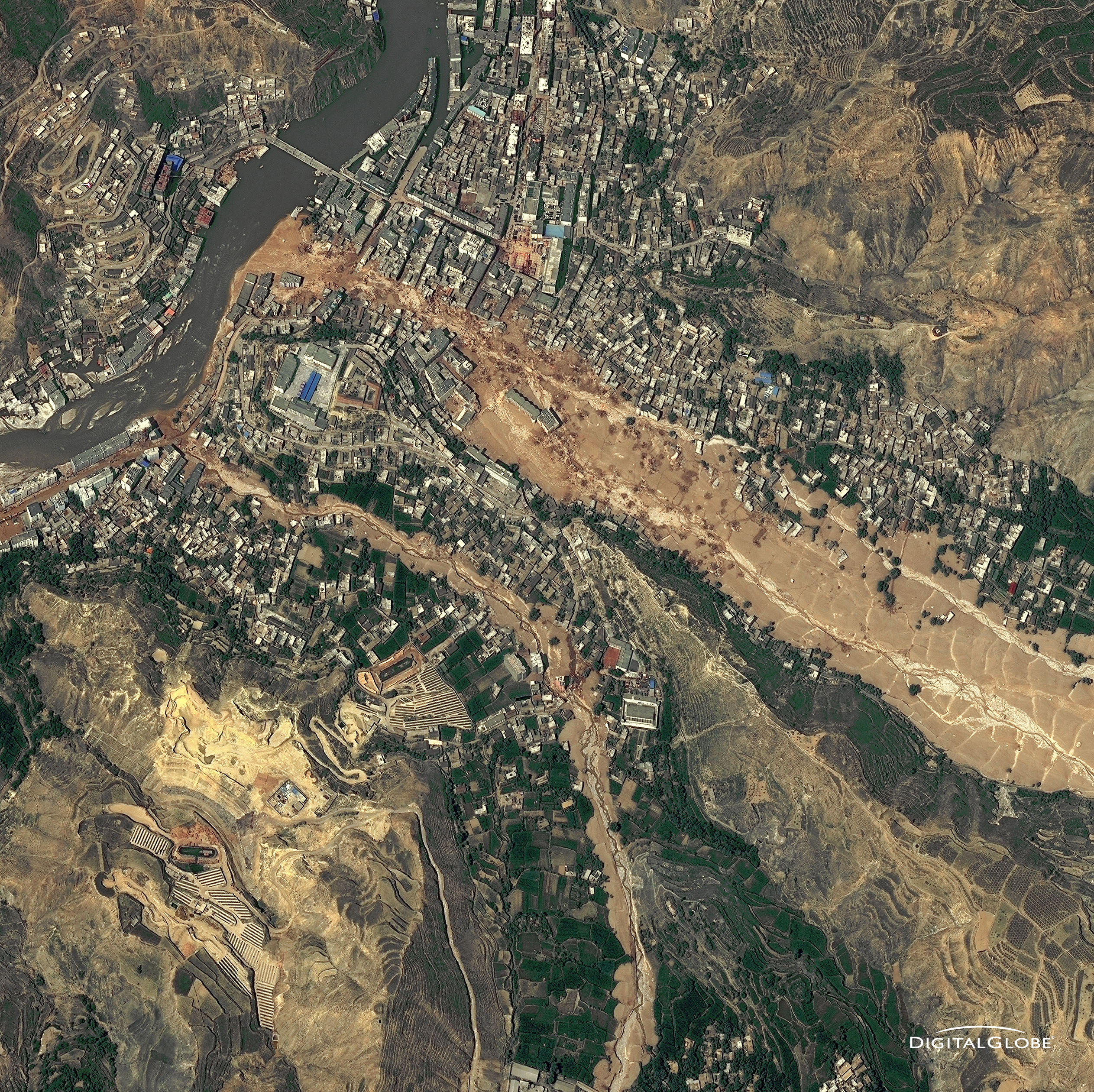
Aerial photo of 2010 landslide in Gansu, China
By Lisa-Natalie Anjozian , NASA Goddard Space Flight Center Original www.nasa.gov Press Release (published 11/27/12) A NASA study using TRMM satellite data revealed that the year 2010 was a particularly bad year for landslides around the world. Around midnight on August 8, 2010, a violent surge of loosened earth roared down mountain slopes and slammed into quietly sleeping neighborhoods in Zhouqu County in Gansu, China. The catastrophic mudslides—the deadliest in decades according to state media—buried some areas under as much as 23 feet (7 meters) of suffocating sludge. 1,765 people died...

2010 Landslide in Gansu, China

Aerial photo of 2010 landslide in Gansu, China
Image Caption
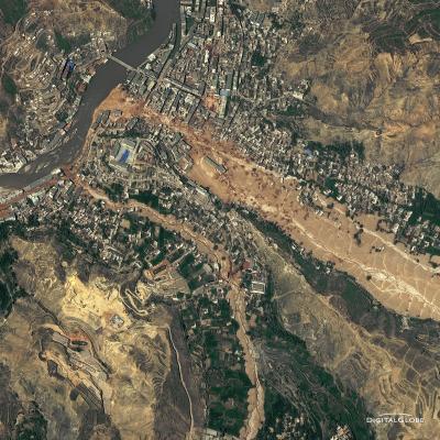
Around midnight on August 8, 2010, a violent surge of loosened earth roared down mountain slopes and slammed into quietly sleeping neighborhoods in Zhouqu County in Gansu, China.

The catastrophic mudslides—the deadliest in decades according to state media—buried some areas under as much as 23 feet (7 meters) of suffocating sludge. 1,765 people died. Property damages totaled an estimated $759 million. Cutting from right to left, this detailed image, from DigitalGlobe’s WorldView-2 satellite, shows the largest slide in the lower part of the city on August 10, 2010.

Image Credit: Digital Globe, DigitalGlobe usage policy

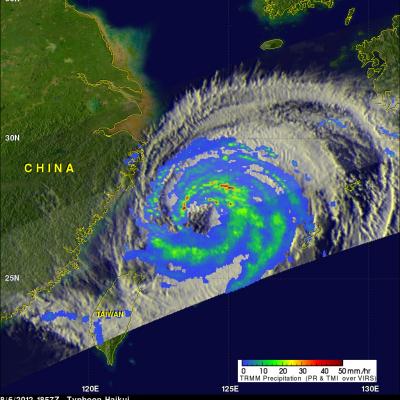
Typhoon Haikui Heading Toward China

The TRMM satellite had a good view of Typhoon Haikui on August 6, 2012 at 1857 UTC as it was moving toward China. At that time Haikui was a category one typhoon on the Saffir-Simpson hurricane intensity scale with wind speeds of 65 kts (~75 mph). Data from TRMM's Microwave Imager (TMI) and Precipitation Radar (PR) instruments show bands of moderate to heavy rainfall around Haikui's large eye. TRMM PR data were also used to show a 3-D cross section through Haikui's eye. This view shows that intense rainfall (45 dBZ) was occurring in the eastern side of Haikui's eye. Typhoon Haikui weakened

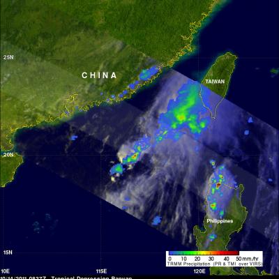
Tropical Depression Banyan

The TRMM satellite collected data on 14 October 2011 at 0837 UTC that were used to make the images above of tropical depression Banyan (known as Ramon in the Philippines). Tropical storm Banyan was the latest killer cyclone to hit the Philippines this year following closely on the heels of typhoons Nesat and Nalgae. Banyan resulted in the reported deaths of at least nine people in the Philippines before weakening and moving into the south china sea as a tropical depression. TRMM satellite data shows that Banyan, although small, contained some powerful convective storm near the center of the

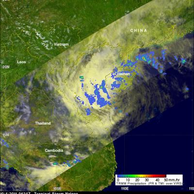
Tropical Storm Nalgae Weakens

was a tropical storm and weakening rapidly when the TRMM satellite saw it on 4 October 2011 at 0624 UTC. This rainfall analysis from TRMM's Microwave Imager (TMI) and Precipitation Radar (PR) shows only scattered areas of light to moderate rainfall were present with Nalgae as it moved into the Gulf Of Tonkin west of Hainan. Click here to see earlier TRMM information about Nalgae.

Nalgae Exits The Philippines and Heads Toward China

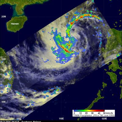
The TRMM satellite had a good look at typhoon Nalgae on 2 October 2011 at 0637 UTC after it became the second typhoon in a week to hit the Philippines. Nalgae was in the middle of the South China Sea headed toward southern Hainan. In this image a rainfall analysis from TMI and PR data was overlaid on a combination Infrared and Visible image from TRMM's Visible and InfraRed Scanner (VIRS) instrument. See earlier information about Nalgae