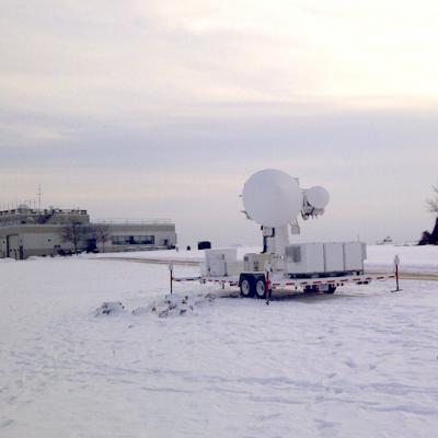
D3R

NASA's D3R radar at the GCPEx field campaign.
By Ellen Gray, NASA Goddard Space Flight Center Original www.nasa.gov Feature (published 1/31/12) Predicting the future is always a tricky business -- just watch a TV weather report. Weather forecasts have come a long way, but almost every season there's a snowstorm that seems to come out of nowhere, or one that's forecast as 'the big one' that turns out to be a total bust. In the last ten years, scientists have shown that it is possible to detect falling snow and measure surface snowpack information from the vantage point of space. But there remains much that is unknown about the fluffy white...

Laying the Groundwork - First Photos from the Field!

GPM's ground validation scientist, Walt Petersen sent us our first photos from the CARE site in Ontario, Canada. Snow's already on the ground, now we're just waiting for more to fall! The University of Bonn ADMIRARI Radiometer deployed at the CARE site. It measures microwaves that are naturally emitted from Earth's surface to determine water vapor and cloud and liquid water in the air column. Credit: NASA / Walt Petersen The NASA D3R radar deployed at the CARE site. 
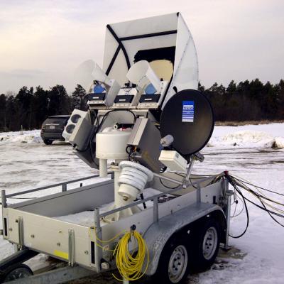
This radar scans the air column for snow falling from the clouds to the ground. It uses two frequencies that together can
Document Description

Background and Purpose:
This specification defines the Level 3, system-level functional and performance requirements for NASA’s Global Precipitation Measurement (GPM) mission Ground Validation System Mobile Radar (GVSMR).

Document Description

Detailed specifications document for the Dual-Frequency, Dual-Polar, Doppler Radar (D3R)

Dual-frequency Dual-polarized Doppler Radar (D3R)

Submitted by JacobAdmin on Thu, 02/24/2011

The D3R will operate as part of GPM Ground Validation, supporting GPM pre-launch algorithm development and will contribute to post-launch precipitation product validation. In the pre-launch era, the D3R provides independent estimation of hydrometeor classification and drop size distribution retrievals. The radar thus offers an insight into the microphysical processes that dominate the retrieval (and associated measurement error) of precipitation types and rates from satellite data.