droughts

California's Drought Improving

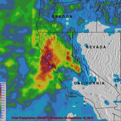
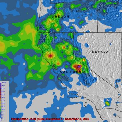
Waves of rainfall from Pacific Ocean storms show signs of improving the exceptional drought conditions that have been plaguing California. Starting on about November 30, 2014 storms frequently moved over California. A Multi-satellite Precipitation Analysis (MPA) using data (3B42) archived at near "real time" at the NASA Goddard Space Flight Center was used in the analysis. It indicates that northern California has had far more beneficial rainfall than southern California. This analysis shows that storms dropped over 350mm (almost 14 inches) in an area north of San Francisco. Southern

California's Rainfall Analyzed From Space

It has been very dry in the state of California for the past couple years. The lack of rain in 2013 and 2014 contributed to exceptional drought conditions in the state. Records were set over the past winter for the lowest winter snow packs recorded in a century. Rainfall produced by storms moving into California from the Pacific Ocean has recently brought some very temporary drought relief. Precipitation data (3B42) from various satellites such as TRMM and recently the GPM core observatory satellite have been collected, merged and archived at the Goddard Space Flight Center since 1998. The

GPM: Too Much, Too Little

Submitted by JacobAdmin on
Video Embed

Researchers need accurate and timely rainfall information to better understand and model where and when severe floods, frequent landslides and devastating droughts may occur. GPM’s global rainfall data will help to better prepare and respond to a wide range of natural disasters.

Video Text: 

Dalia: GPM will help us to understand precipitation extremes. And this is everything from too much rainfall, such as flooding in India or Southeast Asia, to too little rainfall such as drought in the U.S. Southwest.