Fernanda

GPM Views Dissipating Hurricane Fernanda

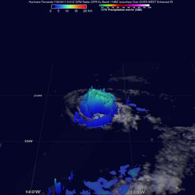
The GPM core observatory satellite had another exceptional view of hurricane Fernanda when it flew over on July 20, 2017 at 0101 UTC. GPM saw a much different hurricane than it viewed a couple days earlier. GPM's Microwave Imager (GMI) and Dual-Frequency Precipitation Radar (DPR) radar instruments found that the dissipating hurricane only contained heavy rainfall in it's northwestern quadrant. Cooler water, dry air, and southwesterly vertical wind shear had caused Fernanda to weaken. GPM's Radar revealed that powerful convective storms in that part of the dissipating hurricane were still

GPM Examines Hurricane Fernanda's Eye

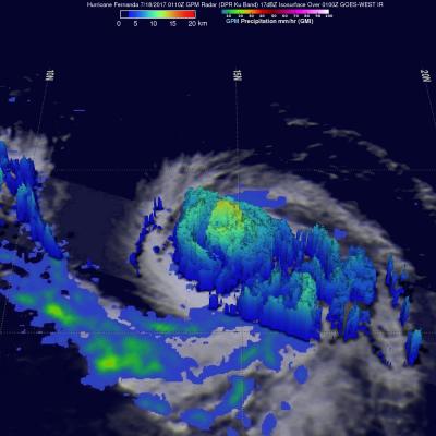
The GPM core observatory satellite had an excellent view of hurricane Fernanda on July 18, 2017 at 0110 UTC. Hurricane Fernanda had weakened from it's peak wind speed of 125 kts (143.75 mph) attained on July 15, 2017 but still had maximum sustained wind speeds of about 95 kts (109 mph). This meant that Fernanda was still a powerful category two hurricane on the Saffir-Simpson hurricane wind scale. GPM's Microwave Imager (GMI) and Dual-Frequency Precipitation Radar (DPR) data showed the location of intense rainfall circling around Fernanda's eye. Measurements by GPM's Radar (DPR Ku band) showed

Colder Water Chills Fernanda

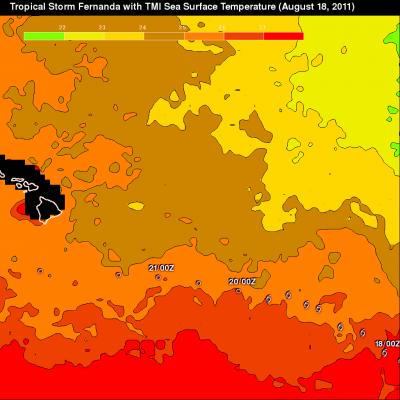
Ocean water warmer than 26C is a necessary condition for tropical cyclones to support convection. A TMI based Sea Surface Temperature (SST) analysis for three days ending on 18 August 2011 is shown above. Tropical Storm Fernanda's path (overlaid in white) recently took it over ocean waters colder than 26 Celcius so it has weakened considerably. The TRMM satellite passed over Fernanda on 19 August 2011 at 0648 UTC. The TMI and PR rainfall analysis from this pass shows that there is now very little rainfall with the weakening storm. See earlier news about Tropical Storm Fernanda

TD06 Becomes Tropical Storm Fernanda

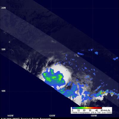
The National Hurricane Center (NHC) upgraded tropical depression 06E to tropical storm Fernanda on 16 August 2011 at 0800 UTC after seeing data from a TRMM pass at that time. A rainfall analysis from TRMM Microwave Imager (TMI) rainfall data shows that Fernanda contains areas of heavy rainfall. Fernanda was located about 2378 km (~1478 miles) east-southeast of the Hawaiian Islands with wind speeds of about 45 kts (~52 mph) and was moving toward the west at about 8 kts (~9.2 mph). The NHC discussion says that computer guidance indicates considerably more intensification is possible with