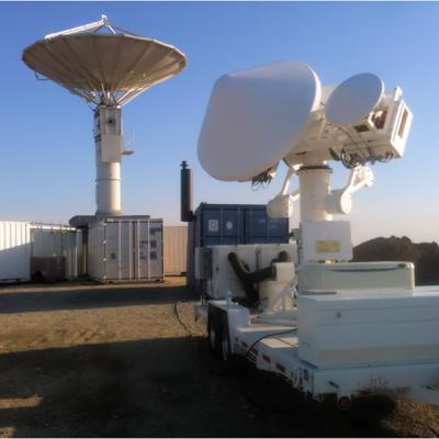
Field Campaigns

DROP field campaign instruments
I ntegrated P recipitation and H ydrology EX periment The Integrated Precipitation and Hydrology Experiment (IPHEx) is a ground validation field campaign that will take place in the southern Appalachian Mountains in the eastern United States from May 1 to June 15, 2014. IPHEx is co-led by NASA's Global Precipitation Measurement mission , with partners at Duke University and NOAA's Hydrometerological Testbed. The field campaign has two primary goals. The first is to evaluate how well observations from precipitation-monitoring satellites, including the recently launched GPM Core Observatory...
Ground validation radars.
The Global Precipitation Measurement (GPM) Core Observatory, launched on Feb. 27, 2015, from Tanegashima Space Center in Japan, will help advance our understanding of Earth's water and energy cycles, improve the forecasting of extreme events that cause natural disasters, and extend current capabilities of using satellite precipitation information to directly benefit society. The GPM mission will provide unprecedented data on rain and snowfall. The science instruments on the GPM Core Observatory will provide data that will yield the greatest clarity on rain and snow yet gathered from orbiting...

Faces of GPM: Professor Steve Nesbitt, GPM Ground Validation Scientist

Submitted by JacobAdmin on Fri, 12/27/2013
Video Embed

Profile of Steve Nesbitt, a professor of Atmospheric Sciences at the University of Illinois and a mission scientist on GPM ground validation field campaigns. Nesbitt uses the data collected to improve the representation of cloud microphysical processes using radars, aircraft probes, and surface instrumentation in satellite precipitation algorithms to improve global precipitation estimates.

Learn more about Faces of GPM

Video Text: 

PMM Article Image
On a Wednesday afternoon in June, a severe storm outbreak spawned huge thunderstorms across Iowa and western Illinois. NASA's Polarimetric precipitation radar was in place to scan the storms as they swept through the region. "It's unbelievable out here," Walt Petersen of NASA's Wallops Flight Facility in Virginia wrote in an email dispatch from Traer, Iowa. There, two NASA radars were stationed as part of the Iowa Flood Studies field campaign, which Petersen led, for the Global Precipitation Measurement, or GPM, mission. Caption: A cluster of rain gauges and soil moisture sensors deployed in...
IFloodS Observes Severe Storm Outbreak
Development of low storm clouds in the atmospheric mixing layer over the NPOL and D3R radars on June 12, 2013 at ~12:00 p.m. CDT. Credit: Walt Petersen /NASA . On Wednesday afternoon, June 12, a severe storm outbreak developed and moved across central and eastern Iowa, and then western Illinois, spawning huge thunderstorms and several tornadoes. NASA's Polarimetric (NPOL) precipitation radar, currently deployed in Iowa as part of the Iowa Flood Studies field campaign for the Global Precipitation Measurement mission, rapidly scanned these storms as they moved across the state. NPOL capturing...