Floods

GPM Flies Over Flooding Rainfall in Washington DC

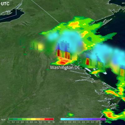
Washington DC experienced extreme rainfall the morning of July 8th, 2019 when a cluster of slow-moving thunderstorms moving through the area tapped into a very moist airmass to produce extremely heavy rains, which resulted in flash flooding throughout the region. The storms were triggered by a nearby frontal boundary. The GPM Core Observatory passed over this storm system at 8:51am ET, with its Dual-frequency Precipitation Radar measuring rainfall rates in excess of 100 mm/hr in some areas. Reagan National Airport (DCA) also reported receiving 80 mm of rainfall in one hour, corroborating the
Flooding Rainfall Over the U.S. East Coast Examined by GPM JacobAdmin Thu, 07/26/2018
Flood watches and warnings have been issued today for states from North Carolina through New York. Major flooding of rivers and streams is forecast in Pennsylvania as heavy rainfall continues. A Large blocking high located east of Nova Scotia and Low Pressure over the upper mid west has been funneling moisture over the Mid-Atlantic states. This weather pattern includes a strong upper level trough with it’s axis becoming oriented from the Great Lakes through the eastern Gulf Of Mexico. This resulted in a dip in the jet stream that has been transporting tremendous amounts of moisture from the

Southern Texas' Flooding Rainfall Examined With IMERG

Extremely heavy rainfall caused a flash flood emergency over southern Texas this week. More than 15 inches (381 mm) of rain fell in Hidalgo County, Texas since Tuesday June 19, 2018. The Governor of Texas declared a state of emergency for six counties in South Texas Thursday afternoon. Heavy rain had ended Friday morning but occasional showers were still occurring over southern Texas. At 4:28 AM CDT Friday June 22, 2018 the National Weather Service in Brownsville, Texas issued a "Flood Warning for Urban Areas and Small Streams in... Southwestern Hidalgo County in Deep South Texas..."

GPM Data Used to Evaluate Hawaii's Flooding Rainfall

A low pressure trough moving slowly westward through the northwestern Hawaiian Islands caused destructive flooding and mudslides over the past weekend. The trough disrupted the normal northeast trade winds flow north of Oahu on April 12, 2018. This caused extremely heavy rainfall as the trough deepened and moved very slowly over Kauai during the weekend. The 28.1 inches (713 mm) of rain reported in Hanalei within a 24 hour period was close to a record for the small town on Kauai's northern coast. Almost 32.4 inches (822 mm) of rain was reported during the same period over Wainiha, Kauai
Atmospheric River Slams California
Video Embed
JacobAdmin Mon, 01/23/2017

After more than four years of drought, Californians may wonder where the current rain is coming from. Using satellites, NASA scientists have a unique view of the sources of precipitation, and how it reaches the western United States.

Atmospheric River Slams California
After more than four years of drought, Californians may wonder where the current rain is coming from. Using satellites, NASA scientists have a unique view of the sources of precipitation, and how it reaches the western United States. Rain is often carried by narrow tendrils of moisture called atmospheric rivers that occur all over the world, shown here in white. The atmospheric rivers that affect the western United States are known as the Pineapple Express because they transport water vapor from as far south as Hawaii to California. When the moisture reaches land, it is forced up over the...

Deadly Tornadoes & Flooding Hits The Southeast

Severe thunderstorms spawned tornadoes and generated flooding rainfall over the Southeast on Monday evening. At least twelve tornadoes were reported with twisters spotted in Mississippi, Alabama and Georgia. Four deaths in Alabama and one in Florida have been blamed on this violent weather. Total rainfall was measured from December 30, 2016 through early January 3, 2017 using precipitation estimates from NASA's Integrated Multi-satelliE Retrievals for GPM (IMERG) data. IMERG data are produced using data from the satellites in the GPM Constellation, and is calibrated with measurements from the

GPM Gets a Closer Look at Louisiana Floods

Submitted by JacobAdmin on Thu, 09/29/2016
Video Embed

This visualization begins with an overview of the United States showing the clouds and rainfall accumulation of the massive rain event over Louisiana beginning on August 11th, 2016 through August 13th, 2016. The camera then begins to zoom in as time resets to August 11th. Time then slows way down on August 12th to show the first of GPM's passes. In this close up of GPM's volumetric DPR data over Louisiana, a cutting plane materializes into view to show the inner structure of this giant storm system.

Monsoons: Wet, Dry, Repeat

Submitted by JacobAdmin on Thu, 06/23/2016
Video Embed

The monsoon is a seasonal rain and wind pattern that occurs over South Asia (among other places). Through NASA satellites and models we can see the monsoon patterns like never before. 

Monsoon rains provide important reservoirs of water that sustain human activities like agriculture and supports the natural environment through replenishment of aquifers. However, too much rainfall routinely causes disasters in the region, including flooding of the major rivers and landslides in areas of steep topography.

Monsoons: Wet, Dry, Repeat
Credit: NASA/Goddard/Ryan Fitzgibbons This video is public domain and along with other supporting visualizations can be downloaded from the Scientific Visualization Studio The monsoon is a seasonal rain and wind pattern that occurs over South Asia (among other places). Through NASA satellites and models we can see the monsoon patterns like never before. Monsoon rains provide important reservoirs of water that sustain human activities like agriculture and supports the natural environment through replenishment of aquifers. However, too much rainfall routinely causes disasters in the region...