Floods

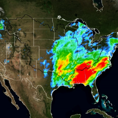
Slow-moving Frontal System Brings Heavy Rains, Flooding to Parts of Texas

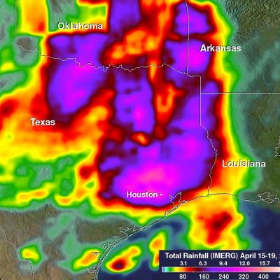
A slow-moving frontal system associated with a stagnant upper-air pattern set the stage for heavy rains and flooding early this week from East Texas all the way up through the Central and Northern Plains. The hardest hit region was in and around the Houston area. On Monday, the National Weather Service reported that Houston International Airport broke its all time daily rainfall record with 9.92 inches of rain. Elsewhere in Harris County, over 17 inches of rain was recorded as of Monday evening. The main culprit was a stationary upper-level low pressure center spinning over the Central Rockies

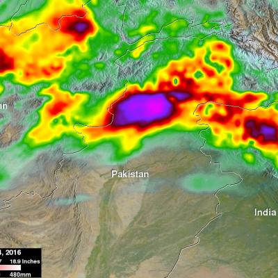
IMERG Measures Flooding Rainfall In Pakistan

Over the past few days heavy rainfall caused flooding that killed more than 50 people in northwestern Pakistan. Heavy pre-monsoon rainfall moved through the area resulting in extensive damage in the Swat Valley northwest of Islamabad the capital of Pakistan. Data from NASA's Integrated Multi-satellitE Retrievals for GPM (IMERG) were used to estimate the rainfall that occurred from April 1-4, 2016. Up to 308 mm (12.1 inches) estimated by IMERG to have fallen during this period.
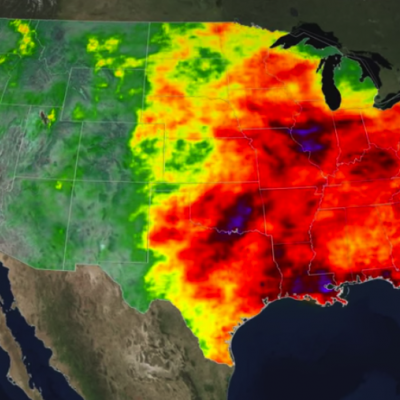
Rainfall Floods the Mississippi River
A series of winter storms brought more than 20 inches of rainfall to the Midwest and southeastern United States in December 2015. Massive flooding followed throughout both the regions. An animation of rainfall data from those storms was created at NASA's Goddard Space Flight Center in Greenbelt, Maryland. This animation shows the accumulation of rainfall over the United Stated during December 2015, from the IMERG precipitation dataset. The black outline indicates the Mississippi-Missouri River basin. This version has been edited to only show the periods of significant rainfall during the month...

GPM 2015: One Year of Storms

Submitted by JacobAdmin on
Video Embed

As we enter the new year, take a look back at the snowstorms, tropical storms, typhoons, hurricanes and floods captured and analyzed by the Global Precipitation Measurement (GPM) mission from around the globe during 2015. 

The complete list of storms by date and location are as follows:

1. New England Nor’easter – January 26 – New England, USA
2. Snowstorm – February 17 – Kentucky, Virginia and North Carolina, USA
3. Tornadic Thunderstorms in Midwest – March 25 – Oklahoma and Arkansas, USA

<iframe width="490" height="276" src="https://www.youtube.com/embed/oiGzKmfOvkg?rel=0" frameborder="0" allowfullscreen></iframe>
As we enter the new year, take a look back at the snowstorms, tropical storms, typhoons, hurricanes and floods captured and analyzed by the Global Precipitation Measurement (GPM) mission from around the globe during 2015. The complete list of storms by date and location are as follows: 1. New England Nor’easter – January 26 – New England, USA 2. Snowstorm – February 17 – Kentucky, Virginia and North Carolina, USA 3. Tornadic Thunderstorms in Midwest – March 25 – Oklahoma and Arkansas, USA 4. Typhoon Maysak – March 30 – Yap Islands, Southwest Pacific Ocean 5. Rain Accumulation from Cyclone...
A Tale of Two Extremes: Rainfall Across the US
The United States has seen a tale of two extremes this year, with drenching rains in the eastern half of the country and persistent drought in the west. A new visualization of rainfall data collected from space shows the stark contrast between east and west for the first half of 2015. The accumulated precipitation product visualized here begins on Jan. 1, 2015, and runs through July 16, 2015. This visualization shows the heavy rainfall throughout Northern Texas and across Oklahoma as well as the drought in Southern California. Credits: NASA Goddard's Scientific Visualization Studio Download...
Satellite-Based Flood Monitoring Central to Relief Agencies' Disaster Response
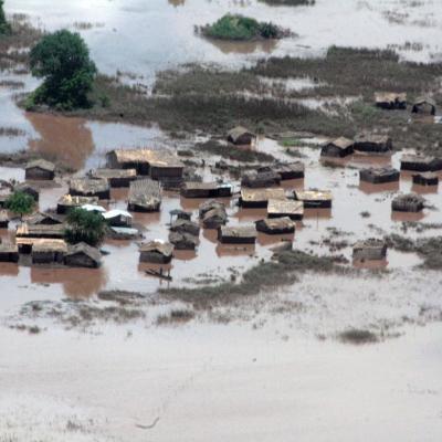
In January 2015, the Shire River in Malawi, and Zambezi River in Mozambique were under tight scrutiny. Weeks of torrential rains led these and other rivers to burst their banks displacing 390,000 people across the region. In southern Malawi 220,000 acres of farmland were turned into a lake, cutting off roads and stranding thousands of people on patches of high ground. The flood was devastating for the country, but within 72 hours of it being declared an emergency the United Nations World Food Programme (WFP) was on the ground distributing food to residents. The quick response was supported by...

Severe Flooding Hits Central Texas, Oklahoma

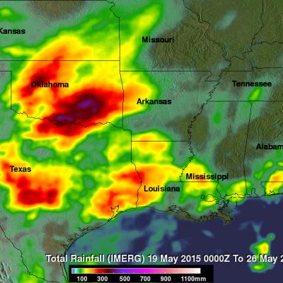
A stagnant upper-air pattern that spread numerous storms and heavy rains from central Texas up into Oklahoma has resulted in record flooding for parts of the Lone Star State. One of the hardest hit areas was in Hays County Texas south of Austin where the Blanco River rose rapidly and set a new record crest at over 40 feet, 13 feet above flood stage, following a night of very heavy rain in the area, with over 12 inches reported locally in a short period of time, in an area already wet from previous storms. The combination of high pressure over the southeastern United States and a persistent

"Pineapple Express" Brings Heavy Rains, Flooding to U.S. West Coast

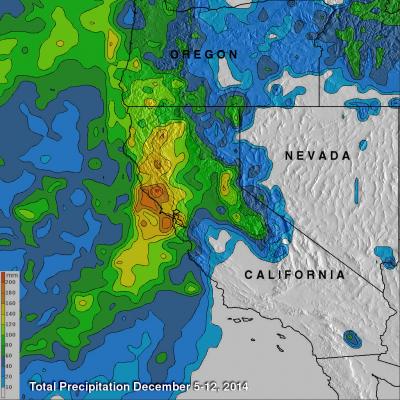
The West Coast, which has been suffering from a strong drought, is finally seeing some much needed relief as a steady stream of storms and rain pour into the coast from the Pacific. The rains began in Washington and Oregon and have now worked their way down the coast to southern California. The weather pattern responsible for all of the rain is known as the "Pineapple Express." The Pineapple Express is known as an atmospheric river. A large, slow-moving low pressure center off of the West Coast taps into tropical moisture originating around the Hawaiian Islands, which is then channeled