Floods

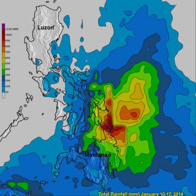
Deadly Philippine Flooding And Landslides

People in the southern Philippines are used to heavy rainfall this time of the year but rainfall totals have recently been exceptionally high. A tropical low northeast of Mindanao has been an almost permanent feature on weather maps for the past week. It has caused nearly continuous rain in the area of northeastern Mindanao triggering floods and landslides that have caused the reported deaths of 34 people. The TRMM Multi-Satellite Precipitation Analysis (TMPA), produced at Goddard Space Flight Center, combines the rainfall estimates generated by TRMM and other satellites (3B42) . The analysis
IFloodS Observes Severe Storm Outbreak
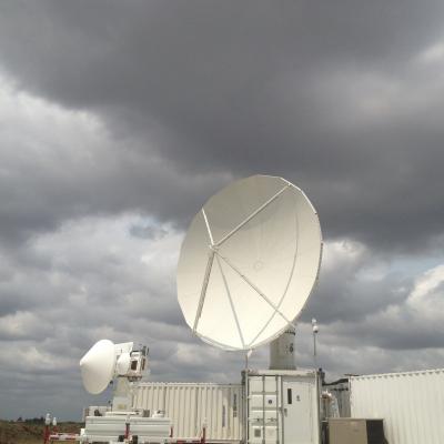
Development of low storm clouds in the atmospheric mixing layer over the NPOL and D3R radars on June 12, 2013 at ~12:00 p.m. CDT. Credit: Walt Petersen /NASA . On Wednesday afternoon, June 12, a severe storm outbreak developed and moved across central and eastern Iowa, and then western Illinois, spawning huge thunderstorms and several tornadoes. NASA's Polarimetric (NPOL) precipitation radar, currently deployed in Iowa as part of the Iowa Flood Studies field campaign for the Global Precipitation Measurement mission, rapidly scanned these storms as they moved across the state. NPOL capturing...

GPM: Too Much, Too Little

Submitted by JacobAdmin on Fri, 06/07/2013
Video Embed

Researchers need accurate and timely rainfall information to better understand and model where and when severe floods, frequent landslides and devastating droughts may occur. GPM’s global rainfall data will help to better prepare and respond to a wide range of natural disasters.

Video Text: 

Dalia: GPM will help us to understand precipitation extremes. And this is everything from too much rainfall, such as flooding in India or Southeast Asia, to too little rainfall such as drought in the U.S. Southwest.

PMM Article iFloods Banner
By Ellen Gray, NASA Goddard Space Flight Center Original www.nasa.gov Feature (published 4/30/13) Ground data now being collected in northeastern Iowa by the Iowa Flood Studies experiment will evaluate how well NASA's Global Precipitation Measurement (GPM) mission satellite rainfall data can be used for flood forecasting. GPM is an international satellite mission that will set a new standard for precipitation measurements from space, providing worldwide estimates of precipitation approximately every three hours. The GPM Core Observatory, provided by NASA and mission partner the Japan Aerospace...

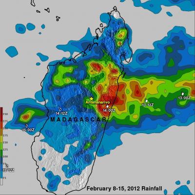
Deadly Tropical Cyclone Giovanna Floods Madagascar

The rainfall analysis above uses near-real-time, TRMM-based precipitation estimates (3B42)from a merger of all available satellite data. This Multi-satellite Precipitation Analysis (TMPA) done at the NASA Goddard Space Flight Center provides estimates of rainfall over the global Tropics. This rainfall analysis shows the rainfall from February 8-15, 2012 that was mainly caused by tropical cyclone Giovanna when it passed over Madagascar. This analysis indicates that the highest rainfall totals of over 250mm (~10 inches) fell in the coastal area east of Madagascar's capitol of Antananarivo. In

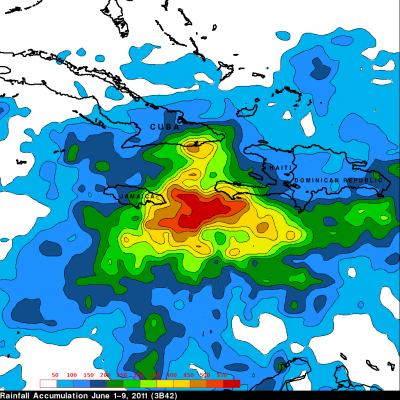
Persistant, Heavy Rains lead to Flooding in Haiti

A trough of low pressure draped across the Greater Antilles together with a persistent area of broad low pressure located in the western Caribbean combined to bring a weeks worth of steady and often heavy rains to the region. This resulted in flooding across portions of Haiti, Jamaica, the Dominican Republic, Puerto Rico, and the Virgin Islands. The Tropical Rainfall Measuring Mission satellite, which was launched in November of 1997 uses both passive and active sensors to measure rainfall over the global tropics from space. To increase the effective coverage, TRMM can be used to calibrate
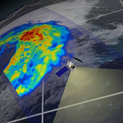
GPM flying over Earth with a data swath visualized.
In July 2010, monsoon rains put one fifth of Pakistan under water. In December 2010 and January 2011, Tropical Cyclone Tasha and a wet year combined to drown Queensland, Australia. And in the United States this May, flooding on the Mississippi River has displaced thousands of people. Over months or a few short hours, extreme rain can interact with the right combination of topography, land use and climate to trigger deadly and costly floods. Submerged houses in Louisiana due to extreme flooding caused by Hurricane Katrina To better understand and predict floods scientists have developed...