Franklin

GPM Overpass of Tropical Storm Franklin on Aug. 29 2023
After becoming a tropical storm in the east-central Caribbean on the afternoon of Aug. 20 and moving generally westward for two days, Tropical Storm Franklin took a northward track and struck the southern coast of the Dominican Republic south of Barahona on the morning of Aug. 23 as a moderate tropical storm with sustained winds reported at 50 mph by the National Hurricane Center (NHC). Franklin brought heavy rains and flooding to the area, resulting in landslides, power outages and at least 2 fatalities in the Dominican Republic according to media reports . After traversing the mountainous

GPM Sees Franklin Becoming A Hurricane

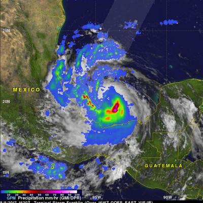
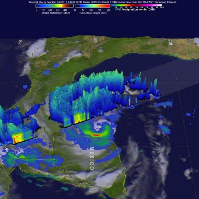
As expected, tropical storm Franklin intensified and was upgraded to hurricane Franklin in the afternoon of August 9, 2017. Franklin made landfall on the coast of eastern Mexico early this morning as a category 1 hurricane with winds of over 86 mph (75 kts). Heavy rainfall, flash floods and mudslides are expected as Franklin moves inland and weakens. The remnants of Franklin may survive the transit over Mexico's rough terrain and revive after moving into the eastern Pacific Ocean. The GPM core observatory satellite saw tropical storm Franklin with winds of about 69 mph (60 kts) as it was

GPM Sees Intensifying Tropical Storm Franklin

The GPM core observatory satellite had an informative pass over Tropical storm Franklin on August 9, 2017 at 0302 UTC. The intensifying tropical storm had moved from Mexico's Yucatan Peninsula into the southwestern Gulf Of Mexico's Bay of Campeche. GPM's Microwave Imager (GMI) and Dual-Frequency Precipitation Radar (DPR) data showed that Franklin contained a few heavy bands of convective rainfall. GPM's DPR found rain falling at a rate of over rain 2.4 inches (62 mm) per hour in bands of intense storms moving around the southwestern side of the storm. This 3-D view of tropical storm Franklin

Short-Lived Tropical Storm Franklin

Tropical Storm Franklin was only active for a short time but the TRMM satellite had a fairly good view when it passed above on Saturday August 13 at 0115 UTC. TRMM's Microwave Imager (TMI data shows that Franklin was dropping some light to moderate rainfall north-northeast of Bermuda. Franklin became extra-tropical a little later as it moved into the open waters of the north Atlantic.