Gillian

Gillian's Persistent Remnants

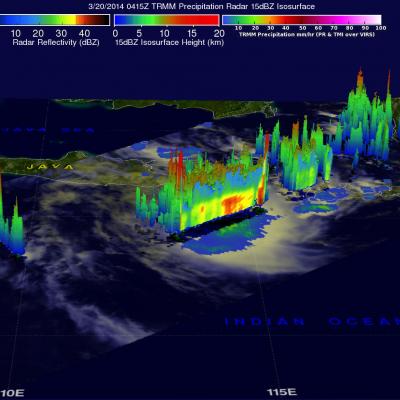
The persistent remnants of tropical cyclone GILLIAN have moved westward over 2700km (about 1674 miles) since forming in the Gulf Of Carpentaria on March 8, 2014. GILLIAN's coherent remnants were located just to the southeast of the Indonesian island of Java when the TRMM satellite flew over on March 20, 2014 at 0415 UTC. TRMM's Precipitation Radar (PR) instrument revealed that intense convective storms in this area were still dropping rain at a rate of over 97 mm/hr (about 3.8 inches) and returning radar reflectivity values of over 51dBZ. TRMM PR data were used in the simulated 3-D view on the

Tropical Cyclone Gillian's Remnants

Over the past few days former tropical cyclone GILLIAN's remnants moved from the Gulf Of Carpentaria into the Timor sea . The TRMM satellite found a few strong convective thunderstorms when it passed above these remnants on March 18, 2014 at 0431 UTC. TRMM's Precipitation Radar (PR) instrument measured rain falling at a rate of over 86 mm/hr (~3.4 inches) in some intense storms. The simulated 3-D image above was made using TRMM PR data and shows that several of the tallest thunderstorms in GILLIAN's remnants were reaching heights of over 15.75 km (~9.8 miles). Radar reflectivity values of over

Tropical Cyclone Formation

The TRMM satellite flew above northern Australia on March 14, 2014 at 0500 UTC capturing data used in the image on the right. Very strong convective storms in this area are the remnants of tropical cyclone GILLIAN and may signal a rebirth. TRMM's Precipitation Radar (PR) instrument found rain falling at the rate of over 116 mm/hr (~4.5 inches) in these powerful storms in the northeastern Gulf Of Carpentaria. TRMM PR data were also used in this 3-D view of the strong convective storms in the northern Gulf Of Carpentaria. Some towering convective storms were found to be very energetic. Several

High Level Of Tropical Cyclone Activity South Of The Equator

Tropical cylone activity has recently increased in the the Southern Hemisphere. On March 10, 2014 the TRMM satellite viewed three tropical storms within two hours. The images above use data received by the TRMM satellite when it flew above tropical storm HADI on March 10, 2014 at 0528 UTC. TRMM found that almost all heavy rainfall with HADI was located in the Coral Sea well off the northeastern coast of Australia. Data from TRMM's Precipitation Radar (PR) instrument were used in the image on the right to show the 3-D structure within the tropical storm. Tropical storm LUSI was located near