GPM

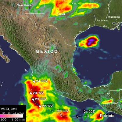
GPM Transitioning its Web-based Global Displays

What: Google Earth access for near-realtime IMERG and 3B42 KML files will be replaced by an updated service for viewing precipitation data in near-real time on a 3D virtual globe using Cesium ( https://cesiumjs.org/ ). When: The current plan is to make the cut-over to the new Cesium-based service on or about October 16, 2016. Why: The evolution of network policies and applications prevents continued GPM use of Google Earth. Note: If you wish to continue using KML files with a non-Google Earth client, please contact the Precipitation Measurement Missions at: https://pmm.nasa.gov/contact
Hurricane Patricia Makes Landfall in Mexico
The eye of hurricane Patricia hit the Mexican coast on October 23, 2015 at approximately 6:15 PM CDT(2315 UTC)near Cuixmala, Mexico. The maximum winds at that time were estimated to be 143 kts (165 mph). Patricia is weakening rapidly but continued heavy rain is expected to cause flash floods and mudslides in the Mexican states of Nayarit, Jalisco, Colima, Michoacan and Guerrero through Saturday October 24, 2015. Over the weekend the remants of Patricia are also expected to add to the extreme rainfall in Texas. Rainfall from a stalled front that has been causing flooding in northern and central...
NASA Aids Response to Carolina Flooding
It was rain that wouldn't quit. A weather system fueled by warm moisture streaming in from the Atlantic Ocean on Oct. 3 and 4 relentlessly dumped between one and two feet of rain across most of South Carolina. The result was rivers topping their banks and dams bursting. Catastrophic flooding followed across most of the state, which has left residents in some areas without power or clean drinking water. Tracking and predicting the deluge, both as rain and then floodwater, are the first steps to help protect people in harm's way. State and federal emergency managers have been on the front lines...

Tropical Storm Grace Viewed by GPM

On Saturday September 5, 2015 a tropical disturbance south of the Cape Verde Islands in the eastern Atlantic Ocean was designated tropical depression number seven (TD7). TD7 was subsequently upgraded to tropical storm Grace that evening after the tropical depression showed increasingly better organization. The GPM core observatory satellite flew above tropical storm Grace on September 6, 2015 at 0111 UTC. Data captured by GPM's Microwave Imager (GMI) and Dual-Frequency Precipitation Radar (DPR) instruments with that pass showed that the tropical storm was small but had well defined curved
Global Precipitation Measurement (GPM) Is In Position to Watch Effects of 2015’s El Niño
Since late in 2014, scientists in many different disciplines (including meteorologists, climate scientists, physical and biological oceanographers, hydrologists, and geologists) have been watching a slow-to-develop El Niño even in the tropical Pacific Ocean. After teasing observers with conditions that did not quite meet El Niño criteria 1 , the event finally reached official El Niño status in March and April, and is now expected to become a powerful event lasting into the next Northern Hemisphere winter. If these conditions, typified by warm sea surface temperatures (SST) in the tropical...
OLYMPEX Field Campaign map
The Olympic Mountain Experiment (OLYMPEX) The Olympic Mountain Experiment, or OLYMPEX, was a NASA-led field campaign, which took place on the Olympic Peninsula of Washington State from November 2015 through February 2016. The goal of the campaign was to collect detailed atmospheric measurements that will be used to evaluate how well rain-observing satellites measure rainfall and snowfall from space. In particular, OLYMPEX assessed satellite measurements made by the Global Precipitation Measurement (GPM) mission Core Observatory, a joint mission by NASA and the Japan Aerospace Exploration...
Satellite-Based Flood Monitoring Central to Relief Agencies' Disaster Response
In January 2015, the Shire River in Malawi, and Zambezi River in Mozambique were under tight scrutiny. Weeks of torrential rains led these and other rivers to burst their banks displacing 390,000 people across the region. In southern Malawi 220,000 acres of farmland were turned into a lake, cutting off roads and stranding thousands of people on patches of high ground. The flood was devastating for the country, but within 72 hours of it being declared an emergency the United Nations World Food Programme (WFP) was on the ground distributing food to residents. The quick response was supported by...

Large Gap in Near-Realtime Data

Starting at 08:38 UTC PPS stopped getting data from the GPM Mission Operations Center. Data was resumed at 17:21 UTC. However, new GPS data was sent before older GPS data. The science data was sent out of order with the GPS data. This meant that about 125 mins of 1B and 1C GMI data had no geolocation and perhaps more after this had questionable geolocation. The same issues obviously also affected the radar and combined NRT which are just missing for the period between 8:30 UTC and 17:30 UTC. All of these issues impacted the early version of the IMERG data. The late product will also be
Engaging Citizen Scientists With GPM
Every morning at seven, Andrew Welch wakes up, cooks breakfast and checks the rain gauge sitting on a five-foot post in his backyard. He writes down the measurement, sends his kid off to school and then heads out to his workplace as a structural engineer. Welch is a citizen scientist. Around the world, hundreds of citizen scientists like him are collecting precipitation measurements from the ground that are useful for NASA’s Global Precipitation Measurement (GPM) mission. CoCoRaHS volunteers stand with Dr. Walt Petersen, far left, Dr. Jackson Tan, third from right, and Dr. Tiffany Moisan, far...

A GPM View of Tornado Spawning Thunderstorms

Twelve tornado sightings reported to NOAA yesterday were associated with severe thunderstorms extending from the Texas Gulf coast, through Oklahoma and Kansas. The GPM core observatory satellite had a good look at this area of severe weather on April 17, 2015 at 0003 UTC (April 16, 2015 at 7:03 PM CDT). A precipitation analysis using GPM's Microwave Imager (GMI) shows that some of these severe storms were dropping rain at a rate of over 86 mm (about 3.4 inches) per hour. Reflectivity data from the Ku band on GPM's dual frequency radar was used to construct this 3-D view of tornado spawning