Ground Validation

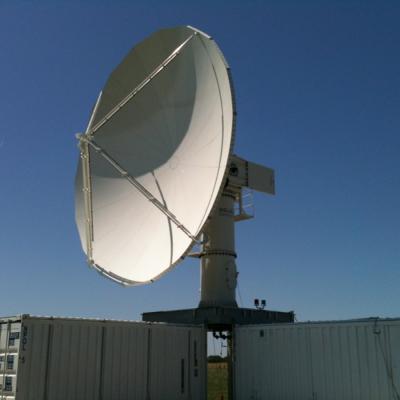
NPOL Ground Validation Instrument

The NPOL instrument, a large circular radar dish under a blue sky
Image Caption
The NASA NPOL radar is a research grade S-band, scanning dual-polarimetric radar.

The NPOL underwent a complete antenna system upgrade in 2010 and is one of two fully transportable research-grade S-band systems in the world.  It is used to make accurate volumetric measurements of precipitation including rainfall rate, particle size distributions, water contents and precipitation type.

GPM flying over Earth with a data swath visualized.
The Light Precipitation Evaluation Experiment (LPVEx) took place in the Gulf of Finland in September and October, 2010 and collected microphysical properties, associated remote sensing observations, and coordinated model simulations of high latitude precipitation systems to drive the evaluation and development of precipitation algorithms for current and future satellite platforms. In doing so, LPVEx sought to address the general lack of dedicated ground-validation datasets from the ongoing development of new or improved algorithms for detecting and quantifying high latitude rainfall...
The NPOL instrument, a large radar dish attached to a trailer under a blue sky
Mid-latitude Continental Convective Clouds Experiment The Midlatitude Continental Convective Clouds Experiment (MC3E) took place from April 22 – June 6, 2011, near Lamont, Oklahoma in the region surrounding the Department of Energy (DOE) Atmospheric Radiation Measurement (ARM) Program Southern Great Plains Central Facility. The experiment was a collaborative effort between the U.S. Department of Energy (DOE) Atmospheric Radiation Measurement (ARM) Climate Research Facility and the NASA's Global Precipitation Measurement (GPM) mission Ground Validation (GV) program. The MC3E ideal scenario...
GPM flying over Earth with a data swath visualized.
Precipitation Processing System (PPS) PPS provides real-time processing and post-processing of the TRMM science data is performed by the TRMM Science Data and Information System (TSDIS). Working with the TRMM principal investigators and science algorithm developers, PPS maintains the operational science data processing system and ensures the timely processing of all TRMM science instrument data. During routine operations, raw instrument data is received in near real-time by PPS and then processed by the first tier of science algorithms to produce calibrated, swath-level instrument data. Using...
Document Description

This document provides a basic set of documentation for the data products available from the GPM Ground Validation System (GVS) Validation Network (VN). In the GPM era the VN performs a direct match-up of GPM’s space-based Dual-frequency Precipitation Radar (DPR) data with ground radar data from the U.S. network of NOAA Weather Surveillance Radar-1988 Doppler (WSR-88D, or “NEXRAD”). Ground radar networks from international partners are also part of the VN.

Document Description

Science plan for the Mid-Continent Convective Clouds Experiment (MC3E), scheduled for the spring of 2011. This campaign will be conducted in cooperation with the Department of Energy's (DoE) Atmospheric Radiation Program (ARM). The field campaign will be conducted in south-central Oklahoma. The goal of the campaign is to contribute to the improvement of radar and microwave precipitation retrieval algorithms over land.