Haruna

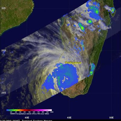
Tropical Storm Haruna Headed For Madagascar

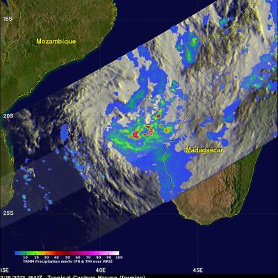
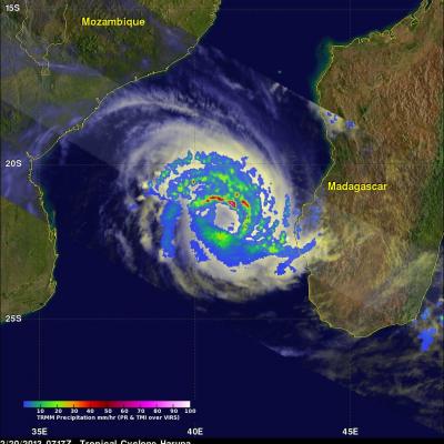
The TRMM satellite had a good look at a tropical storm called Haruna forming in the Mozambique Channel on February 18, 2013 at 1541 UTC. Haruna was called a tropical storm early today and TRMM had another fairly good view when it flew above at 0811 UTC. Haruna is predicted to intensify to a strong tropical storm with wind speeds of about 50kts (~58 mph) and cross southern Madagascar in a couple days. TRMM's Microwave Imager (TMI) and Precipitation Radar (PR) rainfall data were used in the two rainfall analyses shown. TRMM PR showed that very intense rain was falling at a rate of over 134 mm/hr

Tropical Storm Haruna Intensifying

The TRMM satellite flew above intensifying tropical storm Haruna in the Mozambique Channel again on February 20, 2013 at 0717 UTC. A rainfall analysis using data from TRMM's Microwave Imager (TMI) and Precipitation Radar (PR) instruments is shown overlaid on a combination visible/infrared image from the Visible and InfraRed Scanner (VIRS). TRMM showed that Haruna had become much better organized than yesterday with intense bands of rainfall circling the tropical cyclone's center of circulation. Some rain in powerful storms on the northern edge of Haruna's center was found by TRMM PR to be

Deadly Tropical Cyclone Haruna Departs Madagascar

Tropical cyclone Haruna has battered southwestern Madagascar with hurricane force winds and flooding rainfall for the past two days. The city of Morombe was heavily damaged and Haruna was reported to have killed six people. The TRMM satellite passed over Haruna yesterday on February 22, 2013 at 1336 UTC when the tropical cyclone was over southwestern Madagascar. TRMM passed almost directly above weakening tropical storm Haruna again today on February 23, 2013 at 0608 UTC. Haruna weakened from category one hurricane force yesterday to tropical storm force today. Today TRMM's Microwave Imager