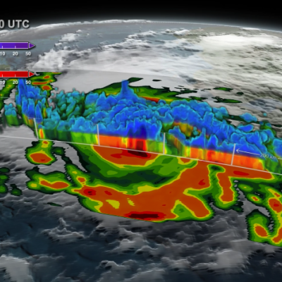
heavy rainfall

GPM Sees Hurricane Matthew Nearing Florida
UPDATE 10/6/16: NASA's Global Precipitation Measurement mission or GPM core observatory satellite flew over Hurricane Matthew several times as the category 4 storm headed toward Florida. The GPM Core Observatory carries two instruments that show the location and intensity of rain and snow, which defines a crucial part of the storm structure – and how it will behave. The GPM Microwave Imager sees through the tops of clouds to observe how much and where precipitation occurs, and the Dual-frequency Precipitation Radar observes precise details of precipitation in 3-dimensions. This data...

Deadly Flooding Gulf Coast Rainfall Measured By NASA's IMERG

An extremely severe rainfall event hit the states of Louisiana and southern Mississippi when a very slow moving low pressure system continuously pulled tropical moisture from the Gulf Of Mexico. Measurements by the GPM core observatory satellite showed that rainfall intensity within the low pressure system actually increased on August 12, 2016 as the low settled over southeastern Louisiana. At least 4 people have died in record flooding after the unusually heavy rainfall starting falling last week. More than 27 inches (686 mm) of rain have been reported in the area. This is the second time

Monsoons: Wet, Dry, Repeat

Submitted by JacobAdmin on Thu, 06/23/2016
Video Embed

The monsoon is a seasonal rain and wind pattern that occurs over South Asia (among other places). Through NASA satellites and models we can see the monsoon patterns like never before. 

Monsoon rains provide important reservoirs of water that sustain human activities like agriculture and supports the natural environment through replenishment of aquifers. However, too much rainfall routinely causes disasters in the region, including flooding of the major rivers and landslides in areas of steep topography.

Monsoons: Wet, Dry, Repeat
Credit: NASA/Goddard/Ryan Fitzgibbons This video is public domain and along with other supporting visualizations can be downloaded from the Scientific Visualization Studio The monsoon is a seasonal rain and wind pattern that occurs over South Asia (among other places). Through NASA satellites and models we can see the monsoon patterns like never before. Monsoon rains provide important reservoirs of water that sustain human activities like agriculture and supports the natural environment through replenishment of aquifers. However, too much rainfall routinely causes disasters in the region...

GPM IMERG Sees Flooding in France

In June 2016, a slow-moving weather system unleashed several days of heavy downpours on western Europe, pushing the Seine River to heights not seen in 34 years. With the Seine’s water levels 6.1 meters (20 feet) above normal in Paris, flood waters knocked out electricity for thousands of people, interrupted road and rail traffic, shut down schools, and caused an estimated 1 billion euros of damage. During the worst of the flooding, the world’s most visited museum, the Louvre, closed as employees scrambled to move artwork out of basement areas that were at risk of flooding. The map above

Rainfall Causes Texas and Oklahoma Flooding

Continuing heavy rain has resulted in dangerous flooding conditions from Oklahoma through eastern Texas. The Brazos, Trinity and Colorado Rivers in Southeastern Texas are at or above flood stage. Flooding resulted in the deaths of at least 6 people in Texas during the past week. Governor Greg Abbott declared a state of disaster in 31 Texas counties. Over 20 inches of rainfall were reported in some areas since May 30, 2016. Parts of Georgia and the Carolinas were flooded by very slow moving tropical depression Bonnie. This estimate of rainfall totals from May 27, 2016 to June 2, 2016 was made

GPM Measures Deadly Flooding Rainfall

Over the past week extreme rainfall caused flooding that resulted in the deaths of four in Haiti and the evacuation of over 2500 people in the Dominican Republic. The GPM core observatory satellite saw a line of heavy rainfall on the eastern side of the Dominican Republic when it flew over on May 8, 2016 at 0428 UTC. GPM's Microwave Imager (GMI) and Dual-Frequency Precipitation Radar (DPR) instruments collected data that were used to estimate rainfall. This precipitation is shown on a top-down satellite view. Powerful storms were measured dropping rain at a rate of almost 300 mm (11.8 inches)

IMERG Measures Flooding Rainfall In Pakistan

Over the past few days heavy rainfall caused flooding that killed more than 50 people in northwestern Pakistan. Heavy pre-monsoon rainfall moved through the area resulting in extensive damage in the Swat Valley northwest of Islamabad the capital of Pakistan. Data from NASA's Integrated Multi-satellitE Retrievals for GPM (IMERG) were used to estimate the rainfall that occurred from April 1-4, 2016. Up to 308 mm (12.1 inches) estimated by IMERG to have fallen during this period.

Peru Flooding Rainfall Measured By IMERG

Heavy rainfall recently caused flooding, landslides and power cuts in some areas of Peru. Thousands were made homeless and at least two people were reportedly killed. Extremely heavy rainfall was reported in northern Peru on February 26 and February 27, 2016. In some areas the Peruvian army was sent to help those affected by flooding. The strong El Niño was partially blamed for the abnormally high rainfall in this area. NASA's Multi-satellitE Retrievals for GPM (IMERG) data collected from February 23-29, 2016 were used to estimate rainfall totals over this area of South America. The highest