
IMERG

Restart of NOAA-19 MHS in IMERG

25 October 2017 At about 4:57 UTC on 9 October 2017 the NOAA-19 MHS precipitation estimates started displaying artifacts, which was eventually traced to the instrument going into safe mode without shutting down data delivery. Since this happened over the long Columbus Day weekend, it took until 01:47 UTC on 10 October 2017 to shut down the data stream, so the Early and Late IMERG have these (very obvious) artifacts for almost 24 hours. No reprocessing is planned. The sensor resumed operations at 17:31:08 UTC on 16 October 2017, but because the basis for the safe mode was unknown, GPM chose to
Artifacts in Early and Late IMERG for 9-10 October

Starting with the first orbit of 9 October 2017, the MHS data from NOAA-19 began displaying substantial artifacts. After the orbit crossing 00 UTC 10 October, the NOAA-19 data have been embargoed from Early and Late IMERG, although it took until 03 UTC for all artifacts to age off the morphing. At this point, Early and Late IMERG appear nominal, except they lack the sampling that NOAA-19 provides.
Using NASA Satellite Data to Predict Malaria Outbreaks
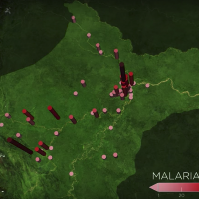
In the Peruvian Amazon, the Anopheles darlingi mosquito is most responsible for spreading malaria. With funding from NASA's Applied Sciences Program, scientists are turning to the agency’s fleet of Earth-observing satellites to develop a system that uses satellite and other data to help forecast malaria outbreaks at the household level months in advance and prevent them from happening. Credits: NASA's Goddard Space Flight Center / Joy Ng In the Amazon Rainforest, few animals are as dangerous to humans as mosquitos that transmit malaria. The tropical disease can bring on high fever, headaches...

Irma’s Heavy Rainfall Measured With GPM IMERG

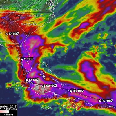
Hurricane Irma dropped extremely heavy rain at times during it’s trek from near the Cape Verdi Islands through the northern Leeward islands, Cuba and the southeastern United States. Over 16 inches (406 mm) of rain was reported in Guantanamo, in the easternmost province of Cuba, as the category five hurricane battered the country. Almost 16 inches (406 mm) of rain was also reported at Fort Pierce on the eastern side of Florida. Charleston, South Carolina reported 6 inches (152.4 mm) of rain in 24 hour. This heavy rainfall plus storm surge flooding caused the worst flooding in Charleston since

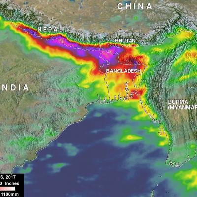
Deadly Southern Asia Flooding Rainfall Measured By NASA's IMERG

Deaths of over 250 people have resulted from extremely heavy monsoon rainfall in parts of northern India, Bangladesh and Nepal. The death toll from flooding and landslides is expected to continue increasing. Heavy monsoon rainfall is normal in southern Asia this time of year but precipitation totals this year are higher than expected. Recent heavy rainfall is also causing the Brahmaputra and Ganges Rivers rivers to continue rising. This rainfall analysis over southern Asia was created using IMERG real time data covering the period from August 10-16, 2017. Total rainfall IMERG estimates of over

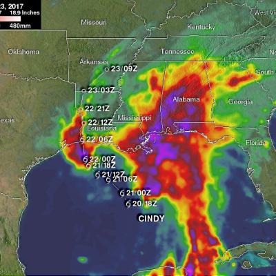
NASA's IMERG Shows Cindy's Extreme Rainfall

Tropical storm Cindy was downgraded to a tropical depression after moving onshore near the Texas and Louisiana Border on Thursday June 22, 2017. Flooding was reported along the the Gulf Coast even before Cindy made landfall. The rainfall around tropical storm Cindy was asymmetrical. The majority of heavy rainfall with the tropical cyclone was located east of Cindy's center in the states along the Gulf Coast from Louisiana through the Florida Panhandle. The tropical depression continued to spread heavy rain and occasionally severe thunderstorms after it came ashore. Severe thunderstorms spawned

V04A IMERG Early GIS friendly products now available

PPS has completed the production of the GIS-friendly TIF/TFW products created from the IMERG Early dataset. These products include running accumulations at 3hr and 1day. The Early TIF/TFW GIS-friendly products have been created back to the beginning of the mission: March 2014. They can be found on jsimpson server in the directories: /NRTPUB/imerg/gis/early/YYYY/MM Documentation for the TIF/TFW products is contained in the document README.GIS.pdf in /NRTPUB/imerg/gis.

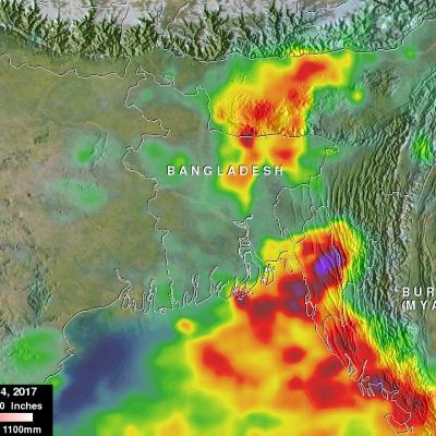
Bangladesh's Heavy Rainfall Examined With IMERG

At least 156 people in Bangladesh were killed during the past week by landslides and floods caused by heavy rainfall. Monsoon rainfall has been especially heavy over this area that includes southeastern Bangladesh, northeastern India and western Burma (Myanmar). This disaster follows quickly on the heels of deadly cyclone Mora which hit the same area a couple weeks ago. This rainfall analysis was made at Goddard Space Flight Center using NASA's near-real time Integrated Multi-satelliE Retrievals for GPM (IMERG) data. Those IMERG data were assembled during the period from June 12-14, 2017. The

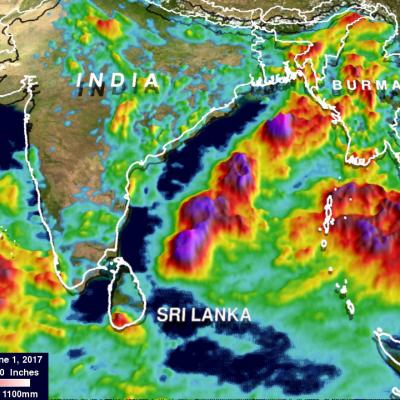
IMERG Shows Heavy Rainfall From Southwest India To Northeast India

In the past couple weeks rainfall has had a significant impact on Sri Lanka, southwestern India, Bangladesh and eastern India. Monsoon rainfall caused widespread flooding, devastating mudslides and displacements of many thousands of people in Sri Lanka. Over 200 people's deaths have now been attributed to this disaster. Then cyclone Mora formed in the Bay Of Bengal on May 27, 2017. Heavy rain from Mora and it's remnants moved over southeastern Bangladesh and northeastern India. Monsoon rainfall also started to move into southern India. This rainfall analysis was derived from NASA's Integrated

Status of IMERG v04 Products

In an effort to keep users informed, below is the current status of the IMERG V04 products. Summary 1. As of 02:20 UTC on 9 May 2017, IMERG Early and Late are running in V04 with backward compatibility adjustments to V05 inputs. 2. From that point to about 11:30 UTC on 12 May 2017, there are long, thin streaks of artifacts in IMERG Early and Late due to GPROF-ATMS. 3. From that point to about 15:00 UTC on 30 May 2017, there are unrealistically large areas of light rain in moist tropical ocean areas in IMERG Early and Late due to GPROF-ATMS and GPROF-MHS. Thereafter, the content of microwave