Ita

Tropical Cyclone Ita Drenches Australia

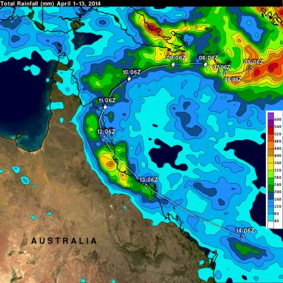
After coming ashore this past Friday tropical cyclone ITA dropped heavy rainfall over the weekend that caused flooding in many areas of northeastern Australia's state of Queensland. IDA has now moved back into the Coral Sea. The analysis above shows a TRMM-based near-real time Multi-satellite Precipitation Analysis (TMPA) made at the NASA Goddard Space Flight Center. This analysis used TMPA precipitation data from April 1-14, 2014 during the period when ITA formed in the Coral Sea and moved along northeastern Australia's coast. IDA's locations at 0600 UTC are shown overlaid in white. The

Powerful Tropical Cyclone Ita Hits Australia

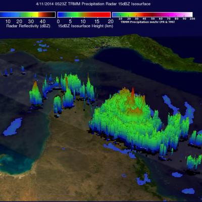
As predicted, powerful tropical cyclone ITA hit the Queensland coast of northeastern Australia late Friday (local time). At that point ITA was a category four on the Saffir-Simpson hurricane intensity scale with winds estimated at over 120 kts (about 138 mph) . This intensity was down slightly from ITA's estimated peak sustained wind speed of 135kts (about 155 mph) when the dangerous tropical cyclone was approaching Australia. The TRMM satellite passed almost directly above as tropical cyclone ITA was approaching the Queensland coast on April 11, 2014 at 0523 UTC. At the time of this TRMM view

TRMM Sees Powerful Tropical Cyclone Ita Approaching Queensland, Australia

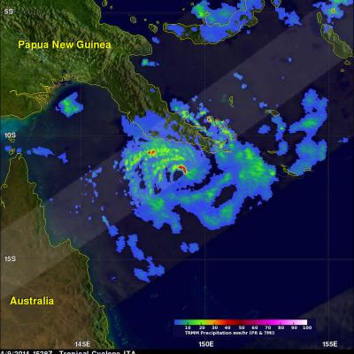
Tropical cyclone ITA, located in the Coral Sea northeast of Australia, continues to intensify while heading toward the northeastern coast of Australia. ITA was seen twice by the TRMM satellite on April 9, 2014. The tropical cyclone's wind speeds had increased from 65kts (about 75 mph) with the first pass at 0536 UTC to 80kts (about 92 mph) when viewed again at 1528 UTC. ITA is predicted to continue becoming more powerful and have sustained winds of 135 kts (about 188 mph) before hitting Australia's Queensland coast tomorrow. TRMM's Precipitation Radar (PR) instrument sliced through ITA's eye

Tropical Cyclone Ita Intensifies

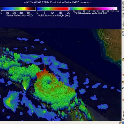
The TRMM satellite flew above intensifying tropical cyclone ITA in the Coral Sea near the southeastern tip of Papua New Guinea on April 9, 2014 at 0536 UTC. The tropical cyclone had developed a large but well defined eye and had sustained winds estimated at 65kts (about 75mph). Rainfall derived from TRMM's Microwave Imager (TMI) and Precipitation Radar (PR) data was used in the analysis shown here. TRMM PR data unveiled rain falling at a rate of over 99mm/hr (about 3.9 inches) within ITA's feeder bands over the coast of southeastern Papua New Guinea. TRMM PR found that tall thunderstorms in