Japan

Super Typhoon Francisco Heads Toward Japan

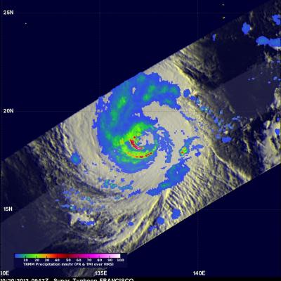
Super typhoon Francisco is headed toward Japan as the country is still recovering from typhoon Wipha. The TRMM satellite flew above the western Pacific and caught a good view of super typhoon Francisco on October 20, 2013 at 0947 UTC. A precipitation analysis from TRMM's Microwave Imager (TMI) and Precipitation Radar (PR) instruments found that rain was falling at the extreme rate of over 207 mm/hr (~8.1 inches) in an area of violent storms southwest of Francisco's eye. TRMM's Precipitation Radar (PR) discovered radar reflectivity values of over 53dBZ in heavy precipitation south of Francisco

Tropical Storm Toraji Adds To Japan's Rainfall

Tropical storm Toraji quickly followed tropical storm Kong-rey and has started to again saturate Japan with flooding rainfall. The TRMM satellite flew over Toraji on September 3, 2013 at 1220 UTC. Rainfall estimates using data collected by TRMM's Microwave Imager (TMI) and Precipitation Radar (PR) instruments with this orbit are displayed in the left image. TRMM PR measured rain falling at a rate of 133 mm/hr (~5.2 inches) in an area just north of Toraji's center of circulation. The image on the right shows a 3-D view from the south of this area using TRMM PR data.

Tropical Storm Kong-Rey To Hit Taiwan Then Japan

Tropical storm Kong-Rey formed in the western Pacific Ocean east of the Philippines on August 26, 2013. Kong-rey passed to the northeast of the Philippines and is predicted to cross over northeastern Taiwan tomorrow. In about three days it is then predicted to be the first tropical cyclone of 2013 to hit southern Japan. The TRMM satellite had an early morning view of tropical storm Kong-Rey on August 27, 2013 at 2203 UTC (~6:03 AM local time). A precipitation analysis from TRMM's Microwave Imager (TMI) and Precipitation Radar (PR) instruments is shown on the left above overlaid on an enhanced

Tropical Storm Talim Weakens, Moves Over Japan

Both Taiwan and Southern Japan have had extreme amounts of rainfall contributed by tropical cyclones during the past week. Tropical storm Talim weakened to a tropical depression on June 18, 2012 after passing over the northern tip of Taiwan. Flooding, landslides and at least one death in Taiwan were reportedly caused by Talim. The weakening tropical depression is now affecting Japan in areas that were just drenched by Typhoon Guchol's passage. This image shows rainfall from data collected with two TRMM satellite orbits as it passed over that area. TRMM passed over on June 20, 2012 at 2308 UTC

Guchol's Rainfall Drenching Japan

The TRMM satellite passed above weakening typhoon Guchol on 18 June 2012 at 2322 UTC as it moved toward Japan's main island of Honshu. Guchol's past and predicted locations are shown overlaid in white. A precipitation analysis from TRMM's Microwave Imager (TMI) and Precipitation Radar (PR) instruments show that the Japanese islands of Kyushu and Shikoku were getting rainfall from Guchol at the time of that orbit. Guchol was shown by TRMM to be enhancing rainfall in parts of Japan over 500 km (~310.7 miles) from the typhoon's center.

Typhoon Roke Brings Heavy Rains to Japan

Typhoon Roke, which made landfall as a Category 1 typhoon along the southeast coast of Honshu near the city of Hamamatsu (about 200 km southwest of Tokyo), was responsible for bringing heavy rains and flooding to most of Japan. Heavy rains actually began effecting parts of southern Japan well before the cyclone neared the coast as tropical moisture from Roke streamed northward into a stalled out frontal boundary that was draped across southern Japan. Japan is also very mountainous, which can enhance the effect. The Tropical Rainfall Measuring Mission or TRMM satellite is used to measure

Typhoon Roke makes Landfall in Central Japan

Roke, a once powerful Category 4 typhoon with sustained winds estimated at 115 knots (~132 mph), came ashore in central Japan Wednesday around 2 pm local time near Hamamatsu on the southeast coast of Honshu (about 200 km southwest of Tokyo) as a Category 1 typhoon. Roke began as a tropical depression ten days ago in the central Philippine Sea about 850 miles (~1370 km) south of Japan. For over a week, the cyclone meandered south of Japan with little change in intensity. Roke finally began to intensify on the 19th of September when it became a typhoon just east of the Ryukyu Islands and then

Two Tropical Cyclones Near Japan

The TRMM satellite flew over two tropical cyclones near Japan on 18 September 2011. Typhoon Sonca, shown above, was seen off the east coast of the main Japanese island of Honshu at 1805 UTC while moving away from Japan toward the north-east. Sonca was still a powerful typhoon with wind speeds of about 85 knots (~98 mph) at that time but Sonca weakened to a tropical storm on 19 September 2011 while moving over the colder waters of the northern Pacific Ocean to the north-east of Japan. TRMM saw tropical storm Roke a little later at 1840 UTC. TRMM Precipitation Radar (PR) data shows that Roke