JAXA

Replacement GPM Ka/Ku L1B products (2017-03-19) for orbit 17356

PPS received replacement GPM Ka/Ku L1B products from JAXA and will reprocess the affected data. If you have already obtained products with orbit #17356 from our archive or through a standing order, etc., please discard and use the replacement products. PPS has replaced the following GPM Ka/Ku L1B data: GPMCOR_KUR_1703190533_0705_017356_1BS_DUB_04A.h5 GPMCOR_KAR_1703190533_0705_017356_1BS_DAB_04A.h5 ------------------------------------- PPS will reprocess these affected downstream products shortly. 2A.GPM.Ka.V6-20160118.20170319-S053318-E070552.017356.V04A.HDF5 2A.GPM.Ku.V6-20160118.20170319

PPS GPM Replacement of Combined and Downstream Products December 08, 2016

PPS received replacement PRL1KA/KU files from JAXA. PPS will reprocess the affected data including combined and downstream products (2AKa, 2AKu, 2ADPR, 2BCMB, 2HCSH, 2HSLH, 3GCSH, 3GSLH) from 2016-12-17 16:31:39 -> 2016-12-17 18:04:13. If you have obtained any of these products from our archive or through a Standing Order, etc., please discard these and use the replacement products. -------------------------------------------------------------------------- The following files and corresponding browse products will be replaced 2A.GPM.Ka.V6-20160118.20161217-S163139-E180413.015932.V04A.HDF5 2A

TRMM Spacecraft Re-Entry

June 16, 2015, Update: The Tropical Rainfall Measuring Mission (TRMM) spacecraft re-entered the Earth’s atmosphere on June 15, 2015, at 11:55 p.m. EDT, over the South Indian Ocean, according to the U.S. Strategic Command’s Joint Functional Component Command for Space through the Joint Space Operations Center (JSpOC). The U.S. Space Surveillance Network, operated by the Defense Department's JSpOC, had been closely monitoring TRMM’s descent since the mission was ended in April. Most of the spacecraft was expected to burn up in the atmosphere during its uncontrolled re-entry. Learn more. ----
GPM Satellite Passes Check-out, Starts Mission
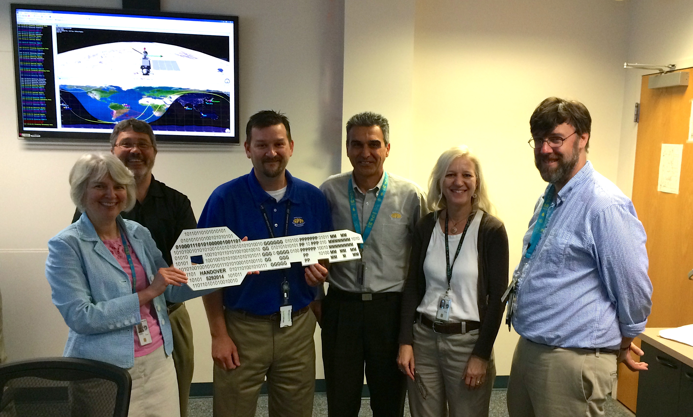
On May 29, GPM Deputy Project Manager Candace Carlisle (left) handed over the "key" to the GPM Core Observatory to GPM Mission Director James Pawloski (center, blue shirt). Also pictured, left to right, Wynn Watson, Art Azarbarzin, Gail Skofronick-Jackson and David Ward. Image Credit: NASA The new Global Precipitation Measurement Core Observatory satellite is now in the hands of the engineers who will fly the spacecraft and ensure the steady flow of data on rain and snow for the life of the mission. The official handover to the NASA / Goddard Earth Science Mission Operations team at NASA’s...

Handover of GPM Key

Handover of GPM Key
Image Caption
On May 29, GPM Deputy Project Manager Candace Carlisle (left) handed over the "key" to the GPM Core Observatory to GPM Mission Director James Pawloski (center, blue shirt).

Also pictured, left to right, Wynn Watson, Art Azarbarzin, Gail Skofronick-Jackson and David Ward.
 

Daruma Doll Delivery

Daruma Doll Delivery
Image Caption
In the Mission Operations Center on May 16, 2014, GPM's NASA and Japan Aerospace Exploration Agency project managers deliver the completed Daruma doll to the members of the Flight Operations team that completed the spacecraft's check-out.
First Images from NASA-JAXA GPM Satellite
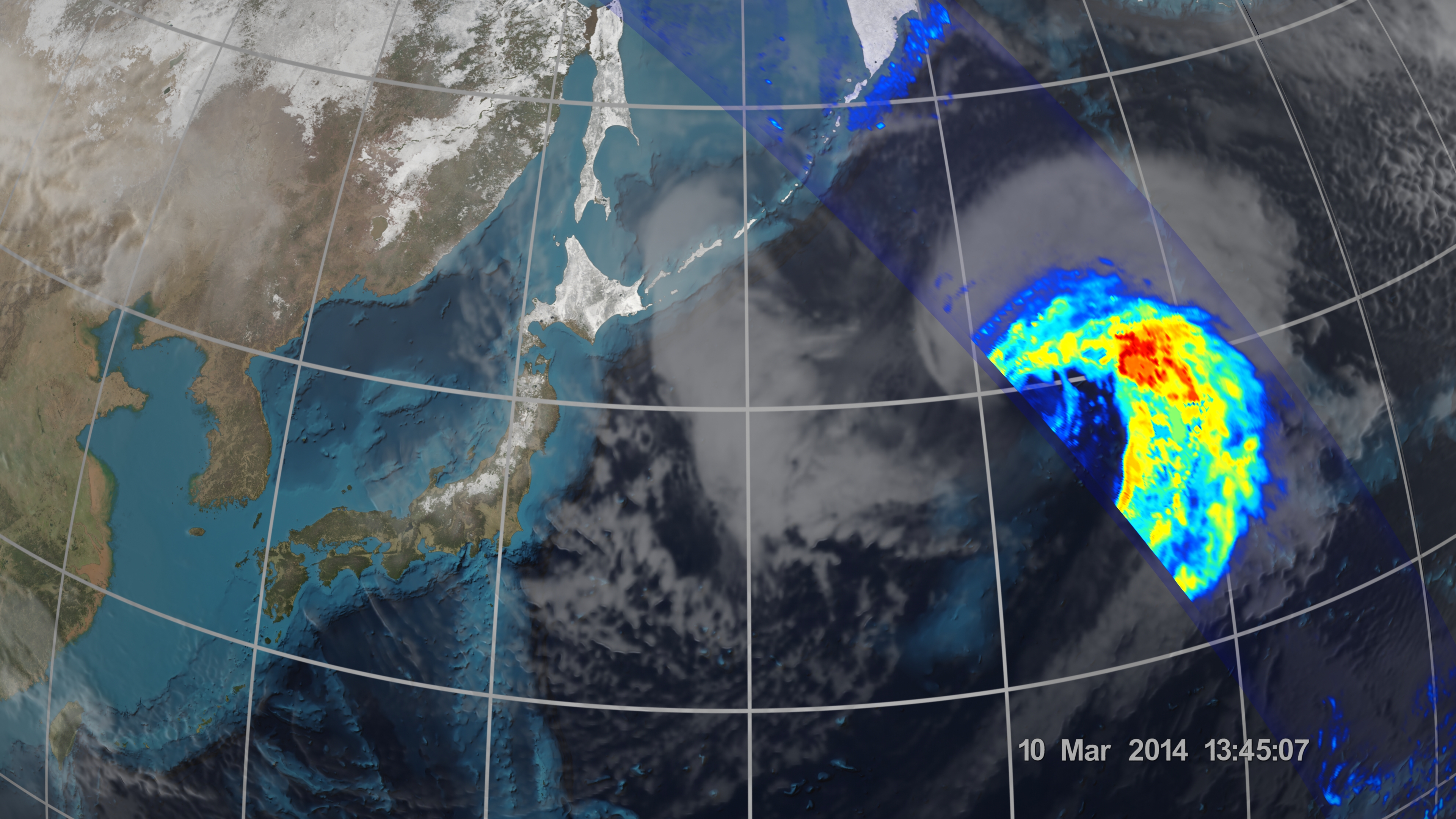
On March 10, the Core Observatory passed over an extra-tropical cyclone about 1055 miles (1700 kilometers) due east of Japan's Honshu Island. Satellite data shows the full range of precipitation in the storm. Image Credit: NASA's Goddard Space Flight Center Download related multimedia in HD formats from NASA Goddard's Scientific Visualization Studio NASA and the Japan Aerospace Exploration Agency (JAXA) have released the first images captured by their newest Earth-observing satellite, the Global Precipitation Measurement (GPM) Core Observatory, which launched into space Feb. 27. The images...

First Images from GPM

First Images from GPM
Image Caption
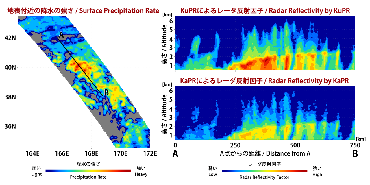
The Dual-frequency Precipitation Radar observes rainfall and snowfall that occurs within clouds in three dimensions, across the surface of the Earth and upward into the atmosphere.
An extra-tropical cyclone was observed over the northwest Pacific Ocean off the coast of Japan on March 10, 2014. 
 
The graph on the left shows the extra-tropical storm seen by the DPR as the satellite passed overhead. The x-axis is the east-west longitude and the y-axis is north-south latitude. The colors show the rain rate at sea-level, with more intense rainfall represented by red and lighter precipitation shown in blue.

First Images from GPM

First Images from GPM
Image Caption
On March 10, the Core Observatory passed over an extra-tropical cyclone about 1055 mi (1700 km) due east of Japan's Honshu Island.

The storm formed from the collision of a cold air mass wrapping around a warm air mass, emerging over the ocean near Okinawa on March 8. It moved northeast over the ocean south of Japan, drawing cold air west-to-east over the land, a typical winter weather pattern that also brought heavy snow over Hokkaido, the northernmost of the four main islands. After the GPM images were taken, the storm continued to move eastward, slowly intensifying before weakening in the central North Pacific. 

Learn More