Mahasen

Deadly Tropical Cyclone Mahasen Comes Ashore

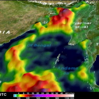
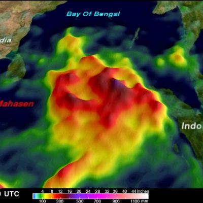
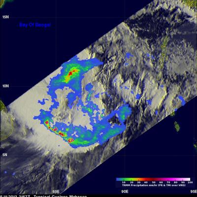
Tropical cylone Mahasen hit southern Bangladesh causing the reported deaths of at least 12 people and the destruction of many homes. Mahasen had heavy rains accompanied with tropical storm force winds when it came ashore. The TRMM satellite had two very informative views as deadly tropical Cyclone Mahasen was moving toward and then over Bangladesh. TRMM passed above Mahasen on May 15, 2013 at 2133 UTC and saw Mahasen again on May 16, 2013 at 0406 UTC after the tropical cyclone's center passed over Bengladesh's Ganges Delta. Red tropical cyclone symbols mark Mahasen's locations with both TRMM

Tropical Cyclone Mahasen Rain Moving Into Bay Of Bengal

Tropical cyclone Mahasen is moving through the Bay of Bengal and is predicted by the Joint Typhoon Warning Center to impact southeastern Bangladesh and northwestern Myanmar (Burma) in about 4 days. This analysis shows a TRMM Multisatellite Precipitation Analysis (TMPA) of rainfall that occurred with tropical cyclone Mahasen during the past week. So far rainfall from Mahasen has fallen mainly over the open waters of the northern Indian Ocean and the Bay Of Bengal. Rainfall totals of about 500mm (~19.7 inches) are shown east of Indonesia in this analysis. Click here to see a rainfall total

Tropical Cyclone Mahasen Moving Into The bay Of Bengal

The TRMM satellite again flew almost directly above intensifying tropical cyclone Mahasen (01B) on May 11, 2013 at 2157 UTC. Rainfall data from TRMM's Microwave Imager (TMI) and Precipitation Radar (PR) instruments are shown overlaid on an infrared image from the Visible and InfraRed Scanner (VIRS). TRMM PR data found that the heaviest rainfall was falling at a rate of over 142 mm/hr (~5.6 inches) in a band of powerful storms well to the southwest of Mahasen's center. At the time of this TRMM pass Mahasen's winds were estimated to be about 50kts (~58 mph). Mahasen's winds are predicted to