North Carolina

GPM Views Southeast Snowstorm JacobAdmin Fri, 06/26/2020
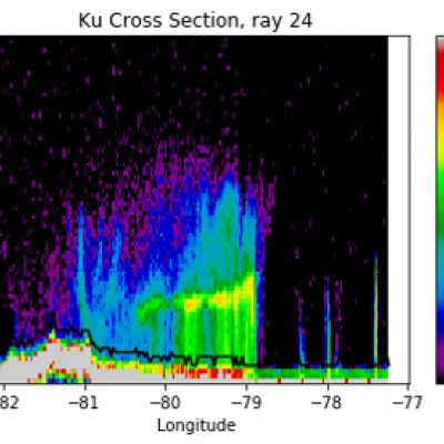
On February 20th and 21st, 2020, a winter storm brought the seasons largest snowfall to much of North Carolina and southern Virginia. The highest snow totals of 3-5 inches (7-12 cm) were located in northeast NC and southeast VA. GPM's radar captured captured the reflectivities shown in this cross-section as it flew over the snow storm on February 20th, with snow and frozen precipitation shown in blue and purple and rain shown in green and yellow. The melting layer marks the transition from snow to rain and slopes upward 2-3 km from central NC to the coast. These raw reflectivity measurements
Deadly Hurricane Matthew's Total Rainfall JacobAdmin Wed, 10/12/2016
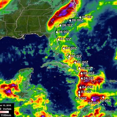
Hurricane Matthew devastated western Haiti and killed over 1,000 people. Matthew also took the lives of at least 37 deaths in the United States with 18 deaths occurring in the state of North Carolina. Flooding is still widespread in North Carolina. Some rivers in North Carolina such as the Tar and the Neuse are still rising. This rainfall analysis was accomplished using data from NASA's Integrated Multi-satelliE Retrievals for GPM (IMERG). IMERG is a unified U.S. algorithm that provides a multi-satellite precipitation product. IMERG is run twice in near-real time with the “Early” multi
Severe Weather In Tornado Alley And Eastward (May 2nd Update) JacobAdmin Mon, 05/02/2016
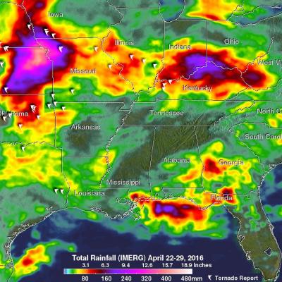
Severe spring thunderstorms frequently spawned tornadoes from the Gulf Coast north and eastward during the past seven days. From April 25 to May 2, 2016 there were over 67 tornadoes in the United States reported to the National Oceanic and Atmospheric Administration (NOAA). Many of these tornadoes were located in an area that includes the states of Texas, Oklahoma, Kansas, and Nebraska. This area of the Great Plains has been labeled Tornado Alley due to the many tornadoes that occur there this time of year. Gulf moisture clashing with frontal systems moving over the United States provided much

Severe Weather In Tornado Alley And Eastward

Severe spring thunderstorms frequently spawned tornadoes from the Gulf Coast north and eastward during the past week. Gulf moisture clashing with frontal systems moving over the United States provided much of the fuel for intense showers and severe thunderstorms. Flash flooding was often the result of the sudden onset of extremely heavy rainfall. Over 305 mm (12 inches) of rain was reported in southern Mississippi in a few hours one morning on April 28, 2016. NASA's Integrated Multi-satellitE Retrievals for GPM (IMERG) data were used to estimate the amount of rain that fell from April 22-29
NASA Begins IPHEx Field Campaign
Rain, ice, hail, severe winds, thunderstorms, and heavy fog – the Appalachian Mountains in the southeast United States have it all. On May 1, NASA begins a campaign in western North Carolina to better understand the difficult-to-predict weather patterns of mountain regions. The field campaign serves as ground truth for measurements made by the Global Precipitation Measurement (GPM) mission's Core Observatory. GPM is an international satellite mission to observe rain and snow around the world. The advanced instruments on the GPM Core Observatory satellite, launched Feb. 27, provide the next...
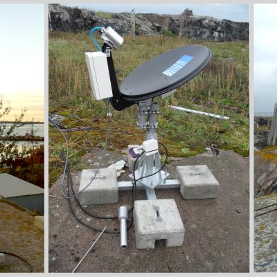
DROP field campaign instruments
I ntegrated P recipitation and H ydrology EX periment The Integrated Precipitation and Hydrology Experiment (IPHEx) is a ground validation field campaign that will take place in the southern Appalachian Mountains in the eastern United States from May 1 to June 15, 2014. IPHEx is co-led by NASA's Global Precipitation Measurement mission , with partners at Duke University and NOAA's Hydrometerological Testbed. The field campaign has two primary goals. The first is to evaluate how well observations from precipitation-monitoring satellites, including the recently launched GPM Core Observatory...

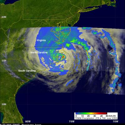
TRMM Views Irene Again Over Cape Hatteras

The TRMM satellite had another very good daytime view of hurricane Irene on 27 August 2011 1750 UTC (1:50 PM EDT). The rainfall analysis shown on the right was derived from TRMM's Microwave Imager (TMI) and Precipitation Radar (PR) data. It clearly shows the location of Irene's eye and the intense rainfall falling over Cape Hatteras east of the eye. Click here to see this image in Google Earth (kml).