Oklahoma
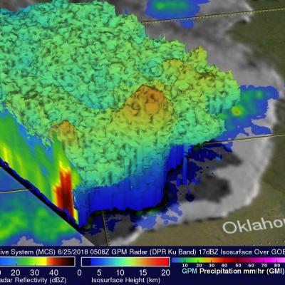
The GPM Core observatory satellite's passed over Oklahoma on Monday, June 25, 2018 04:08 AM CDT (0508 UTC). The satellite makes measurements of precipitation with it's GPM's Microwave Imager (GMI) and Dual-Frequency Precipitation Radar (DPR) instruments every 95 minutes as it orbits the earth at 252.3 miles (407 km). The area covered by GPM's radar is shown in lighter shades. GPM passed directly over the center of a Mesoscale Convective System (MCS) that was moving across Oklahoma. GPM found that the MCS contained some intense storms. GPM's DPR can make accurate rainfall measurements along it
Rainfall Causes Texas and Oklahoma Flooding
Continuing heavy rain has resulted in dangerous flooding conditions from Oklahoma through eastern Texas. The Brazos, Trinity and Colorado Rivers in Southeastern Texas are at or above flood stage. Flooding resulted in the deaths of at least 6 people in Texas during the past week. Governor Greg Abbott declared a state of disaster in 31 Texas counties. Over 20 inches of rainfall were reported in some areas since May 30, 2016. Parts of Georgia and the Carolinas were flooded by very slow moving tropical depression Bonnie. This estimate of rainfall totals from May 27, 2016 to June 2, 2016 was made
Severe Flooding Hits Central Texas, Oklahoma
A stagnant upper-air pattern that spread numerous storms and heavy rains from central Texas up into Oklahoma has resulted in record flooding for parts of the Lone Star State. One of the hardest hit areas was in Hays County Texas south of Austin where the Blanco River rose rapidly and set a new record crest at over 40 feet, 13 feet above flood stage, following a night of very heavy rain in the area, with over 12 inches reported locally in a short period of time, in an area already wet from previous storms. The combination of high pressure over the southeastern United States and a persistent
Tornadoes Hit Southwest
Seven Tornadoes were reported yesterday in a line of violent thunderstorms extending over Oklahoma and Arkansas. One death was reported in a tornado that hit near Tulsa, Oklahoma. The TRMM satellite flew over this line of deadly storms on March 25, 2015 at 11:21 CDT ( March 26, 2015 at 0321 UTC). The first image shows a rainfall analysis that was formed from data collected by TRMM's Microwave Imager (TMI) and Precipitation Radar (PR) instruments at the time of this pass. TRMM PR data indicated that rain was falling at the extreme rate of over 172 mm (6.8 inches) per hour in some powerful
Deadly Tornadoes and Flooding Rainfall in the U.S.
Last week's flooding and tornadoes caused the reported deaths of at least 18 people in Oklahoma. Today extensive flooding from heavy rainfall occurred in Missouri when a levee was breached. The TRMM-based, near-real time Multi-satellite Precipitation Analysis (TMPA) at the NASA Goddard Space Flight Center was used in this analysis to show rainfall over these areas. TRMM with its combination of passive microwave and active radar sensors was used to calibrate rainfall estimates from other satellites. TMPA rainfall totals are shown here for the 21-day period from May 14 to June 4, 2013. Heavy
Tornado in Central Oklahoma

Image Caption
One of several tornadoes observed by NOAA's VORTEX-99 team on May 3, 1999, in central Oklahoma.
Note the tube-like condensation funnel, attached to the rotating cloud base, surrounded by a translucent dust cloud.
Source: NOAA, Wikimedia Commons