Pacific Ocean

GPM Hurricane Douglas 7-25-20
Hurricane Douglas continued to approach the Hawaiian islands during this GPM overpass early in the morning (02:11 UTC) of July 25, 2020. Douglas had previously strengthened to a Category 4 hurricane the day before, but had substantially weakened over cooler waters throughout the day. Regardless, the GMI and DPR instruments recorded rain rates near 50 millimeters/hour (~2 inches/hour) near Douglas` center. The Central Pacific Hurricane Center advised residents of Hawaii to expect hurricane-strength winds and rainfall starting Saturday evening and lasting through Monday. View fullscreen in STORM

GPM Spots Hurricane Pali Forming

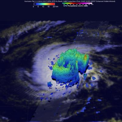
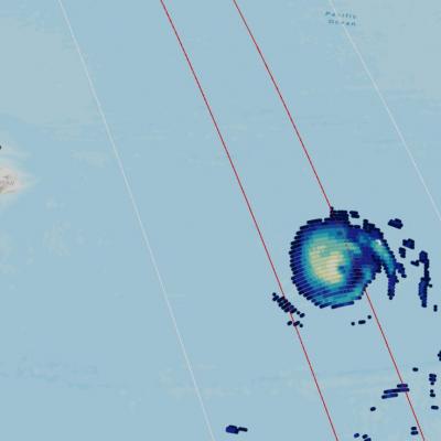
Tropical storm Pali intensified late yesterday to become the earliest hurricane ever recorded in the Central Pacific Ocean. Warm ocean waters from El Nino supplied the extra energy needed for Pali to develop and prosper so early in the year. The GPM core observatory satellite flew over Pali on January 11, 2015 at 2121Z. GPM's Dual-Frequency Precipitation Radar (DPR) data sliced through Pali clearly showing that an eye had formed. GPM's DPR measured rain falling at a rate of 84.5 mm (3.3 inches) per hour on the eastern side of Pali's forming eye. GPM's radar (DPR Ku Band) peered through Pali's

GPM Views Rare Southern Hemisphere Tropical Cyclone

It is a little unusual to see a tropical cyclone forming in the southern Pacific Ocean this time of the year but tropical cyclone 01P formed northeast of Vanuatu recently. The GPM core observatory satellite saw Tropical Cyclone 01P on Monday August 3, 2015 at 2106Z (about 9:06 local time). GPM's Microwave Imager (GMI) found rain falling at a rate of over 30 mm (1.2 inches) per hour in a small area of showers near the center of the tropical cyclone. A 3-D view constructed from GPM's Dual-Frequency Precipitation Radar (DPR) instrument (Ku band) showed that some showers located between the

Tropical Storm Rachel

Tropical depression 18E, located southwest of Mexico, became tropical storm Rachel on September 24, 2014 at 1500 UTC (8 PM PDT). The TRMM satellite had a good view of Rachel when it flew over early today at 0608 UTC (September 25, 2014 at 11:08 PM PDT). A precipitation analysis that used TRMM's Microwave Imager (TMI) data is shown overlaid on a 0600Z GOES-WEST enhanced infrared image. This image shows that, due to northeasterly wind shear, convective precipitation was located southwest of of Rachel's center of circulation. The heaviest rain was shown falling at a rate of over 50mm (amost 2

Super Typhoon Soulik Forms in the Pacific

Typhoon Soulik became the first super typhoon of the year when the Joint Typhoon Warning Center estimated that it's sustained winds had increased to 125 knots (~144 mph), which is equivalent to a Category 4 hurricane on the US Saffir-Simpson scale, at 00 UTC on the 10th of July. Soulik began as a tropical depression on the 8th (local time) about 120 miles (~195 km) east of the Northern Mariana Islands and quickly became a typhoon 24 hours later after moving westward into the Philippine Sea where it continued to intensify. TRMM captured this latest image of Soulik in the central Philippine Sea

Another Tropical Cyclone Developing

While Tropical storm Aletta is forecast to weaken and dissipate another tropical cyclone appears to be forming in the eastern Pacific south of Acapulco, Mexico. The TRMM satellite passed above this tropical disturbance (92E) on 18 May 2012 at 0957 UTC. Data captured with this pass by TRMM's Microwave Imager (TMI) and Precipitation Radar (PR) instruments were used in the rainfall analysis shown. This analysis indicates that this area contained very heavy rainfall in the northeastern quadrant of the disturbance. Some storms were producing rainfall at a rate of over 50 mm/hr (~2 inches). A 3-D