Philippe

IMERG Measures Rainfall From Tropical Storm Philippe Plus Northeast Low

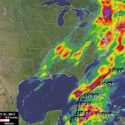
NASA's Integrated Multi-satellitE Retrievals (IMERG) data were used in this analysis to show total rainfall accumulation estimates during the period from October 27 - 31, 2017. Tropical storm Philippe formed and dissipated during that period. The tropical storm formed over the western Caribbean from tropical depression eighteen on October 28, 2017. Philippe then drenched western Cuba as it moved toward the northeast. It dropped a reported 10 inches (254 mm) of rain over southeastern Florida before dissipating in the Atlantic Ocean. Moisture from Philippe's remnants added to heavy rainfall

Philippe Becomes a Hurricane

The National Hurricane Center (NHC) upgraded Philippe to a hurricane at 1500 UTC (11 AM EDT) on Thursday 6 October 2011. Earlier TRMM Microwave Imager (TMI) data from the 6 October 2011 at 0024 UTC view shows that tropical storm Philippe's center of circulation had become better defined with an eye wall forming. The TRMM satellite also had an excellent look at Philippe earlier on Wednesday 5 October 2011 at 1752 UTC (1:52 PM EDT). TRMM's Precipitation Radar (PR) scanned directly over Philippe and revealed that Philippe had bands of intense rainfall around the southeast side of the center of

Philippe's Strength Persists

Philippe was still a tropical storm when the TRMM satellite passed above on 3 October 2011 at 1806 UTC (2:06 PM EDT) but the National Hurricane Center (NHC) predicts that the storm may become a hurricane in a couple days. TRMM's TMI and PR data show that bands of powerful convective thunderstorms were still dropping rain at a rate of over 50mm/hr (~2 inches) near the center of the storm.

Tropical Storm Philippe Shows Signs Of Life

Tropical Storm Philippe, located in the central Atlantic Ocean, has shown signs of strengthening. The TRMM satellite obtained those data used in the above image when it passed over on 2 October 2011 at 1902 UTC ( 3:02 PM EDT). TRMM's Microwave Imager (TMI) and Precipitation Radar (PR) derived rainfall showed that Philippe had powerful thunderstorms in the north-central part of the storm dropping rainfall at a rate over 50 mm/hr (~2 inches). TRMM's PR was used in the image below show a vertical cross section (slice) through one of these thunderstorms. This image shows that one of these tall

Ophelia Reviving and Philippe Weakening

The TRMM satellite passed above two tropical cyclones in the Atlantic Ocean early today. Tropical storm Philippe was seen at 0358 UTC (12:58 PM EDT 26 September 2011) and the regenerating remnants of tropical storm Ophelia were observed at 0529 UTC ( 1:29 AM EDT). TRMM's Precipitation Radar (PR) data were used in these images above to show the vertical structure of both storms. The image above used PR data to show that powerful thunderstorm towers were reaching to heights of over 15km (~9.3 miles) in the center of the increasingly better organized Ophelia remnants. Tropical storm Philippe on