tornadoes

Tornadoes Devastate Parts of the Great Plains

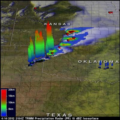
It's springtime in the Plains, which means the increased likelihood that severe weather, including tornadoes, will occur somewhere across the region. After a week of relative quiet, a strong storm system moved out of the southern Rockies and out into the Central Plains. In association with this system, strong southerly winds at low levels drew Gulf moisture up across Texas and into Oklahoma and Kansas while strong jet-stream winds aloft raced northeastward around the base of an upper-level trough over the four-corners region and out over the Plains, setting the stage for a potential severe

NASA's TRMM Satellite Sees Tornadic Texas Storms in 3-D

NASA's Tropical Rainfall Measuring Mission (TRMM) satellite provides a look at thunderstorms in three dimensions and shows scientists the heights of the thunderclouds and the rainfall rates coming from them, both of which indicate severity. Powerful thunderstorms that created severe weather were more than 8 miles high. The TRMM satellite passed above northeastern Texas on April 3, 8:33 p.m. CDT and gathered rainfall and cloud height data from a line of thunderstorms moving through the area. The rainfall image above shows a distinct line of tornadic thunderstorms extending from Arkansas through

TRMM Sees Deadly Tornadic Thunderstorms

Tornadoes are expected to accompany severe storms in the springtime in the U.S., but this time of year they also usually happen. When a line of severe thunderstorms associated with a cold front swept through the U.S. southeast on Nov. 16, TRMM collected rainfall data on the dangerous storms from space. TRMM's Precipitation Radar (PR) data was used to show the line of severe thunderstorms in 3-D. The line of storms were pushing through North and South Carolina on Nov. 16, 2011. Strong updrafts had pushed precipitation within some of these storms to heights of 15km (9.3 miles). Credit: SSAI/NASA