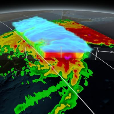
Animation revealing a swath of GPM/GMI precipitation rates over Typhoon Phanfone. The camera then moves down closer to the storm to reveal DPR's volumetric view of Phanphone. A slicing plane dissects the Typhoon from south to north and back again, revealing it's inner precipitation rates. Shades of blue indicate frozen precipitation (in the upper atmosphere). Shades of green to red are liquid precipitation which extend down to the ground. Download in Hi-Res from the Scientific Visualization Studio On October 6, 2014 (0215 UTC) the Global Precipitation Measurement (GPM) mission's Core...
Print resolution still of Typhoon Phanfone being scanned through the center of the DPR data showing the inner volumetric rain rates. Note: Tokyo is immediately to the left of the scan.
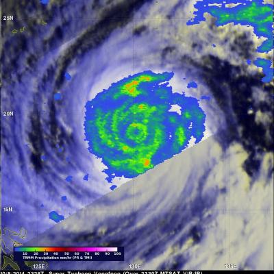
Vongfong was a super typhoon with wind maximum sustained winds of 145 kts (167 mph) when the TRMM satellite flew over on October 8, 2014 at 2328 UTC. Vongfong was the most powerful typhoon since super typhoon Haiyan that killed over 6,000 people after hitting the Philippines in November 2013. In the first image TRMM's Microwave Imager (TMI) shows that Vongfong was producing rainfall over a large area with heavy rainfall revealed in the eye wall and in multiple feeder bands. The small animation shows typhoon Vongfong's rainfall being overlaid on a MTSAT Visible/Infrared image. The Joint Typhoon
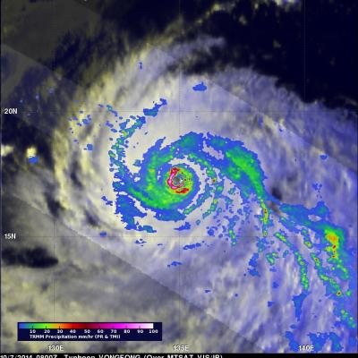
Typhoon Vongfong formed on October 2, 2014 southeast of Guam. Typhoon Phanfone, that recently pummeled Japan, formed near the same area in the western Pacific Ocean. Vongfong had wind speeds of about 120 kts (138 mph) when the TRMM satellite flew above the intensifying typhoon's eye on October 7, 2014 at 0800 UTC. TRMM's Precipitation Radar (PR) showed that powerful storms in Vongfong's eye wall were producing very heavy rainfall. TRMM's Microwave Imager (TMI) show that multiple rain bands spiraling into Vongfong were also dropping rain over a large area. Vongfong is predicted by the Joint
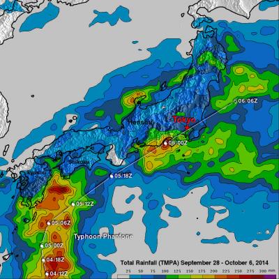
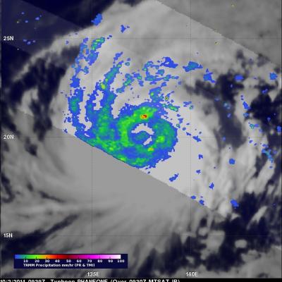
Phanfone was a powerful super typhoon with sustained wind speed estimated at 130 kts ( 150 mph) as it approached Japan but had weakened to a category one typhoon with sustained winds of about 70 kts (81 mph) as is passed near Tokyo. Phanfone's track and locations when the tropical cyclone was near Japan are shown overlaid in white. The TRMM- based, near-real time Multi-satellite Precipitation Analysis (TMPA) at the NASA Goddard Space Flight Center has been measuring the distribution of precipitation over the tropics. TMPA based rainfall totals are shown here for the period from September 28 to
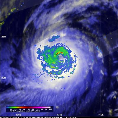
Typhoon Phanfone had sustained wind speeds of about 110 kts (127 mph) and a well defined eye when the TRMM satellite passed over on October 3, 2014 at 0208 UTC. Microwave Imager (TMI) and Precipitation Radar (PR) measurements showed that Phanfone's eye wall and strong feeder bands contained rain frequently falling at a rate of over 60 mm (2.4 inches) per hour. Typhoon Phanfone's wind speeds were predicted today by the Joint Typhoon Warning Center (JTWC) to peak at 120 kts (138 mph) on October 4, 2014 0600 UTC. As a weakening typhoon, Phanfone's course is predicted to change from north
The TRMM satellite again flew over typhoon Phanfone in the western Pacific Ocean on October 2, 2014 at 0939 UTC. Typhoon Phanfone's estimated sustained wind speeds had increased to over 115 kts (about 132 mph). The rainfall pattern observed using TRMM's Microwave Imager (TMI) and Precipitation Radar (PR) data showed that Phanfone was much better organized than a day earlier. This precipitation analysis revealed that intensifying typhoon Phanfone had a large eye. The heaviest rainfall was shown falling at a rate of over 50 mm (almost 2 inches) per hour in the northern side of the typhoon's eye
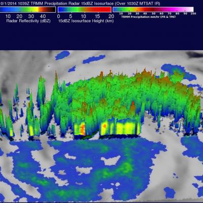
An intensifying typhoon called Phanfone that originated east of Guam on September 28, 2014 is headed toward southern Japan. The TRMM satellite crossed above typhoon Phanfone on October 1, 2014 at 1039 UTC. Rainfall that was made from TRMM's Microwave Imager (TMI) Precipitation Radar (PR) data collected with this orbit is shown in this image. Typhoon Phanfone's winds were estimated to be above 65 kts (about 75 mph) at the time of this TRMM view. Winds within the increasingly powerful typhoon are are expected to increase to over 100 kts (115 mph) in the next few days while moving toward the
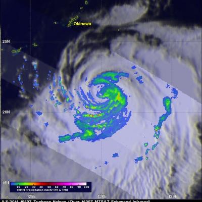
Typhoon Halong was a very dangerous category 5 typhoon a few days ago. Halong was still a strong violent category 2 typhoon with winds of 85kts (about 98 mph) when the TRMM satellite saw it on August 5, 2014 at 1550 UTC. Rainfall derived from TRMM Microwave Imager (TMI) and Precipitation Radar (PR) data is shown overlaid on an enhanced MTSAT infrared image received at 1600 UTC. Rain was shown by TRMM PR to be falling at a rate of over 87 mm (about 3.4 inches) per hour south of the Halong's eye. Typhoon Halong is predicted by the Joint Typhoon Warning Center (JTWC) to hit southern Japan with
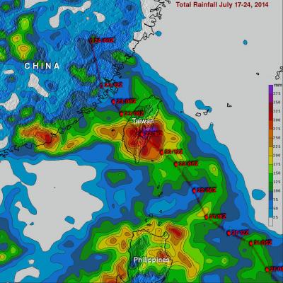
Typhoon Matmo hit eastern Taiwan at it's peak power with winds estimated at 85kts (about 98 mph). In addition to damaging winds Matmo produced very heavy rainfall while passing over central Taiwan. The TRMM-based, near-real time Multi-satellite Precipitation Analysis (TMPA) at the NASA Goddard Space Flight Center was used in this analysis to show rainfall totals for the period from July 17-24, 2014. It shows that rainfall totals greater than 400 mm (about 15.7 inches) soaked eastern Taiwan. Heavy rainfall also occurred yesterday over the Taiwan Strait. This band of heavy rainfall associated