GPM

GPM content

Wednesday September 9, 2015 Japan's Torrential Rain Measured With IMERG

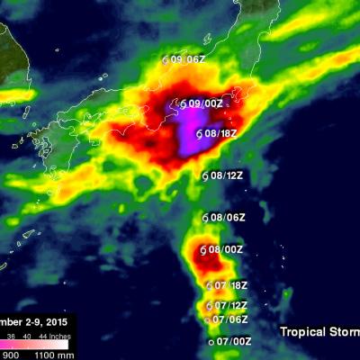
Over the past week Japan has experienced extreme rainfall that resulted in flooding, landslides and many injuries. A nearly stationary front that was already moving over Japan caused much of the rain but tropical storm ETAU also interacted with the front and magnified the scale of the deluge. Heavy rainfall led to the evacuation of over one million people. This rainfall analysis from space was generated using NASA's Integrated Multi-satellite Retrievals for GPM (IMERG) data. It shows rainfall total estimates for Japan during the seven day period from September 2-9, 2015 when Japan was getting

Tropical Storm Grace Viewed by GPM

On Saturday September 5, 2015 a tropical disturbance south of the Cape Verde Islands in the eastern Atlantic Ocean was designated tropical depression number seven (TD7). TD7 was subsequently upgraded to tropical storm Grace that evening after the tropical depression showed increasingly better organization. The GPM core observatory satellite flew above tropical storm Grace on September 6, 2015 at 0111 UTC. Data captured by GPM's Microwave Imager (GMI) and Dual-Frequency Precipitation Radar (DPR) instruments with that pass showed that the tropical storm was small but had well defined curved

GPM Sees Fred Forming In Cape Verdes

Fred became the first Cape Verdes hurricane of the 2015 Atlantic season when it was upgraded from a tropical storm on August 31, 2015 at 0600 UTC (2 AM AST). The GPM core observatory satellite flew over on August 30, 2015 at 0236 UTC when Fred was forming from a tropical wave that moved off the African coast. Rainfall was measured by GPM's Dual-Frequency Precipitation Radar (DPR) at the extreme rate of close to 128 mm (5.0 inches) per hour. Rainfall in towering convective thunderstorms at Fred’s center of circulation were providing the energy necessary for intensification into a hurricane

Ignacio Expected To Pass Near Hawaii

Hurricane Ignacio is the latest tropical cyclone in this busy 2015 eastern Pacific hurricane season to pose potential danger for the Hawaiian Islands. Guillermo passed close to the north, Hilda curved to the south and Kilo's course was threatening before a course change moved it to the south of the islands. The Central Pacific Hurricane Center in Honolulu Hawaii predicts that Ignacio will still be a hurricane when it passes to the northeast of Hawaii in about five days. Rainfall associated with hurricane Ignacio was measured by the GPM core observatory satellite's Microwave Imager (GMI) on

Tropical Storm Erika Enters the Caribbean

Tropical Storm Erika, the 5th named storm of the season, entered the northeast Caribbean early this morning as it passed through the Leeward Islands between Guadeloupe and Antigua. Fortunately, there were no reports of damage thanks in part to the effects of inhibiting wind shear, which kept the storm from strengthening. Erika originated as a wave of low pressure that was first detected on Friday the 21st of August midway between the West Coast of Africa and the Cape Verde Islands. The wave then tracked westward across the tropical mid Atlantic where it eventually intensified enough to become

Hurricane Loke Viewed By GPM

This year the Eastern Pacific Ocean continues to spawn significant tropical cyclones. Hurricane Loke formed southwest of the Hawaiian Islands on August 21, 2015 but Loke has not been a threat to Hawaii because it intensified to hurricane strength while moving well west of Hawaii over the open waters of the Pacific Ocean. The GPM core observatory satellite measured precipitation within the hurricane as it flew above the most powerful storms in the hurricane on August 2015 at 0116 UTC. GPM's Dual-Frequency Precipitation Radar (DPR) measured rain falling at over 160 mm (6.3 inches) per hour in

Tropical Depression Twelve Upgraded To Tropical Storm Ignacio

Today tropical Storm Ignacio became the 16th 2015 tropical cyclone to form in the eastern Pacific this year putting it a couple weeks ahead of last year’s pace. The GPM core observatory satellite saw Ignacio on August 25, 2015 at 2256 UTC. GPM’s Dual-Frequency Precipitation Radar (DPR) found rain falling at a rate of over 74 mm (2.9 inches) per hour with storm tops reaching to altitudes of close to 15 km (8.7 miles).

GPM Sees Energetic Tropical Depression Kilo

Rainfall associated with tropical depression Kilo recently dumped heavy rain in some areas of the state of Hawaii. Tropical depression Kilo changed course to move away from the Hawaiian Islands so it is no longer a threat but has recently been more energetic. The GPM core observatory satellite flew over on August 25, 2015 at 0121 UTC as Kilo approached Johnson Atoll and found that rainfall intensity had recently increased and the tropical depression's storm tops were very tall. GPM's Dual-Frequency Precipitation Radar (DPR) discovered that rain was falling at a rate of almost 65 mm (2.6 inches

Tropical Depression Kilo May Be A Problem For Hawaii

A tropical depression labeled Kilo formed to the southeast of the Hawaiian Islands on August 20, 2015. The tropical cyclone has moved to the southwest of the Islands. The Central Pacific Hurricane Center (CPHC) predicts that Kilo will strengthen into a hurricane as it moves in the general direction of the island of Kauai over the next five days. The GPM core observatory satellite measured the rainfall near Kilo on August 23, 2015 at 0131 UTC. GPM’s Microwave Imager (GMI) and GPM's Dual-Frequency Precipitation Radar (DPR) discovered that rain was falling at a rate of over 121 mm (4.8 inches)
Global Precipitation Measurement (GPM) Is In Position to Watch Effects of 2015’s El Niño
Since late in 2014, scientists in many different disciplines (including meteorologists, climate scientists, physical and biological oceanographers, hydrologists, and geologists) have been watching a slow-to-develop El Niño even in the tropical Pacific Ocean. After teasing observers with conditions that did not quite meet El Niño criteria 1, the event finally reached official El Niño status in March and April, and is now expected to become a powerful event lasting into the next Northern Hemisphere winter. If these conditions, typified by warm sea surface temperatures (SST) in the tropical...