GPM

GPM content

Typhoon Dujuan Batters and Drenches Taiwan

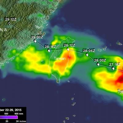
Typhoon Dujuan formed in the western Pacific Ocean northwest of Guam on September 21, 2015. Dujuan intensified to a super typhoon with winds of 125 kts (144 mph) on September 27, 2015 as it approached Taiwan. The island of Taiwan experienced extreme rainfall and damaging winds with the passage of typhoon Dujuan. The typhoon also caused hundreds of injuries and at least three deaths in Taiwan. After pounding Taiwan the typhoon started weakening before hitting China. Dujuan dropped light to moderate rainfall over a large area of coastal China while dissipating. A preliminary analysis of Rainfall

Tropical Storm Joaquin forms in the Western Atlantic

Tropical Storm Joaquin became the 10th named storm of the season after forming late last night (EDT) in the western Atlantic midway between the Bahamas and Bermuda from what was previously a tropical depression (#11), which itself had formed a day earlier from an area of low pressure that had been lingering in the region since Saturday. GPM captured this image of Joaquin early this morning at 8:16 UTC (4:16 am EDT) on the 29th of September as the storm was slowly drifting westward about 390 miles east of the northern Bahamas. The image shows rain rates derived from the GPM GMI (outer swath)

Tropical Storm Marty Tries to Strengthen South of Mexico

Tropical Storm Marty, which formed into an depression from an area of low pressure about 300 miles southwest of Acapulco, Mexico Saturday afternoon (local time), has been trying to strengthen while drifting slowly northward toward the southwest coast of Mexico. This first image was captured by NASA's GPM core satellite at 00:11 UTC 27 September (7:11 pm CDT 26 September) just a few hours after Marty had formed into a tropical depression. GPM shows substantial areas of rain on the eastern half of the storm, but more importantly, there is already evidence of curvature and banding within those

GPM Monitors New Tropical Storm Niala

The GPM core observatory satellite flew directly above newly formed tropical storm NIALA (06C) on September 25, 2015 at 1451 UTC (4:41 AM HST). Rainfall data were collected by GPM's Microwave Imager (GMI) and Dual-Frequency Precipitation Radar (DPR) instruments showing that intense storms just northeast of NIALA's center of circulation were dropping rain at a rate of over 126 mm (4.96 inches) per hour. Another rain band wrapping around NIALA's northeastern side was found to contain rain falling at a rate of over 56 mm (2.2 inches) per hour. 3-D radar reflectivity data collected by GPM's radar

Ida Weakened by Strong Shear in the Atlantic

Tropical Depression Ida has struggled to maintain itself in the Central Atlantic well east of the Leeward Islands where it has been ravaged by strong wind shear. Since forming back on the 18th of September, Ida has not been able to strengthen beyond a moderate tropical storm, reaching a peak intensity of 45 knots (50 mph) early on the morning of the 21st before succumbing to the effects of strong northwesterly winds from an upper-level trough. Since that time, Ida has struggled maintain itself between a depression and a weak tropical storm, while being mired in the Central Atlantic. This most

Meandering Ida's Precipitation Measured By GPM

The GPM core observatory satellite had another good view of meandering tropical storm Ida located in the central Atlantic Ocean on September 24, 2015 at 0756 UTC (3:35 AM EDT). Measurements of precipitation by GPM's Microwave Imager (GMI) and Dual-Frequency Precipitation Radar (DPR) instruments showed that Ida still contained a few embedded strong convective thunderstorms that were dropping heavy rainfall. Some rainfall was measured by GPM's Ku Band radar falling at a rate of 122 mm (4.8 inches) per hour. GPM's 3-D radar reflectivity data (DPR Ku band) can be used to reveal the intensity of
https://www.youtube.com/watch?v=8eIwMXnU8IA&feature=youtu.be
A narrated visualization of Typhoon Kilo. Click here for a full transcript. Click here to download this video in high resolution from the NASA Goddard Scientific Visualization Studio. The Global Precipitation Measurement (GPM) mission core satellite provided many views of Tropical Cyclone Kilo over its very long life. GPM is a satellite co-managed by NASA and the Japan Aerospace Exploration Agency that has the ability to analyze rainfall and cloud heights. GPM was able to provide data on Kilo over its 21 day life-span. The GPM core observatory satellite flew over Kilo on August 25, 2015 at...

GPM Sees Powerful Storms Within Tropical Storm Ida

The GPM core observatory satellite found that tropical Storm IDA contained some very powerful convective thunderstorms when the satellite passed over on September 21, 2015 at 0902 UTC (05:02 AM EDT). The satellite passed directly above the most powerful storms within IDA where rain was measured by GPM's Microwave Imager (GMI) and Dual-Frequency Precipitation Radar (DPR) instruments. DPR found that some thunderstorms were dropping rain at a rate of over 142 mm (5.6 inches) per hour. GPM's DPR (Ku Band) radar data were used examine the 3-D structure of precipitation within tropical storm IDA

GPM Sees Tropical Depression Nine (td9) Forming

Tropical cyclone development has been relatively slow in the Atlantic Ocean in 2015 with tropical depression Nine (TD9) forming today in the central tropical Atlantic. GPM's Microwave Imager (GMI) and Dual-Frequency Precipitation Radar (DPR) instruments collected data today at 1016 UTC (6:16 AM EDT). Data from that pass were used to show the three dimensional (3-D) extent of TD9's rainfall. GPM's 3-D DPR (Ku Band) found that the tallest convective thunderstorms within TD9 were reaching heights of about 14.9 km (9.2 miles) in a feeder band southeast of TD9's center of circulation. The most

Tropical Storm Vamco Brings Rain To Southeast Asia

Tropical storm Vamco formed in the South China Sea on September 13, 2015 and went ashore in Vietnam a few days later. Although short lived Vamco dropped very heavy rainfall over the mountainous terrain of central Vietnam and in Laos and eastern Thailand. An Integrated Multi-satellite Retrievals for GPM (IMERG) rainfall analysis is shown here for the period from September 12-15, 2015. This analysis indicates that during this short period over 220 mm (8.7 inches) rain fell along the tropical storm's path. Flash floods and landslides were likely in areas where this drenching rainfall occurred.