GPM

GPM content

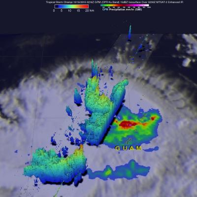
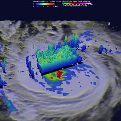
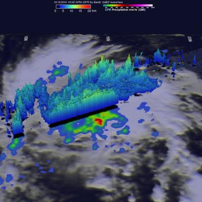
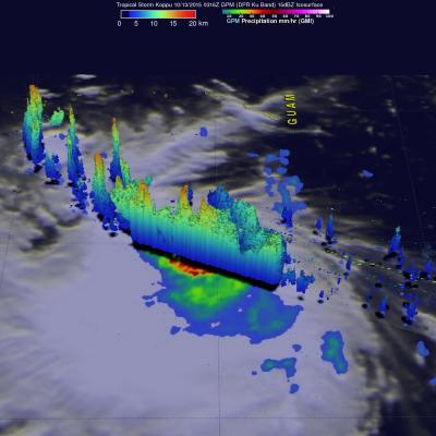
Typhoon Koppu's Deadly Philippine Rainfall

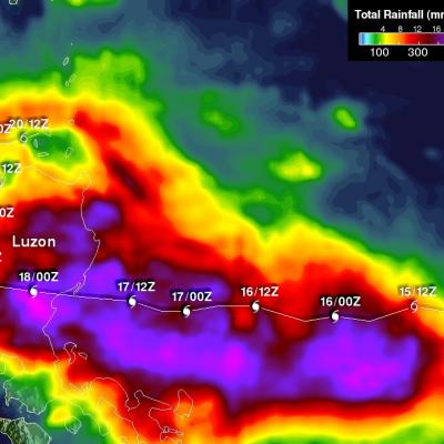
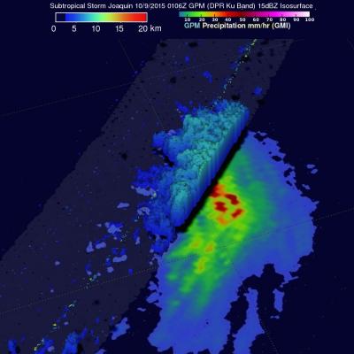
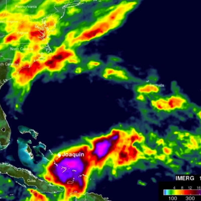
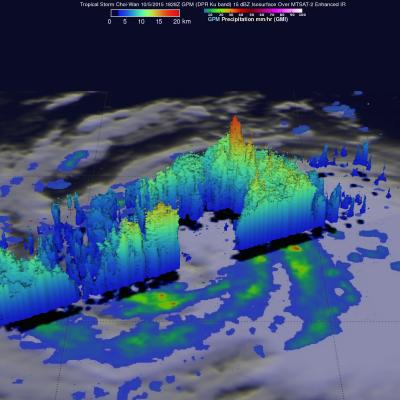
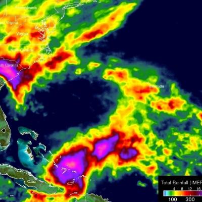
Extremely heavy rainfall from super typhoon Koppu has caused deadly flooding and mudslides in the Philippines. Koppu hit the eastern coast of Luzon as a category four super typhoon with winds of 130kts (150 mph). Koppu weakened but was still battering the Philippines as a typhoon after reaching the Lingayen Gulf on Luzon's western coast. Typhoon Koppu then made a turn toward the north and continued to drench the northern Philippines as it followed Luzon's northwestern coast. Torrents of rain flowing from mountainous terrain magnified the effects of very high rainfall totals. A rainfall

GPM Measures Tropical Storm Champi's Heavy Rainfall

On October 16, 2015 at 0216 UTC the GPM core observatory satellite passed above tropical storm Champi as it was drenching the northern Mariana Islands. GPM's Dual-Frequency Precipitation Radar (DPR) measured rain within Champi falling at a rate of over 114.8 mm (4.5 inches) per hour in a band of intense showers. GPM's radar sliced through Champi's western side and made 3-D measurements of storm top heights. Radar reflectivity values found to be greater than 15 dBZ are shown in a simulated perspective 3-D view. The lowest Heights are shaded blue and the tallest 3-D 15dBZ surfaces are colored

GPM Sees Tropical Storm Koppu Menacing The Philippines

Tropical storm Koppu was approaching the Philippines with sustained winds estimated of 60 kts (69 mph) when the GPM core observatory satellite passed above on October 15, 2015 at 1436 UTC. A rainfall analysis using data collected by GPM's Microwave Imager (GMI) instrument revealed that an eye was very close to forming near Koppu's center of circulation. Rain was measured by GPM's GMI instrument dropping rain at a rate of over 133 mm (5.3 inches) per hour in intense convective thunderstorms just southwest of Koppu's center. Data from GPM's Dual-Frequency Precipitation Radar (DPR) instrument

GPM Views Tropical Depression Twenty Five (25W)

Tropical Depression Twenty Five (TD25W) also formed today. It was located east of Guam and is predicted by the Joint Typhoon Warning Center (JTWC) to move toward the west-northwestward and pass to the north of Guam. TD25W is expected to become a typhoon with maximum sustained winds of 75 kt (86 mph) on October 18, 2015. The GPM core observatory satellite saw TD25W on October 13, 2015 at 1313 UTC. GPM found that TD25W contained moderate to heavy rainfall falling at a rate of up to 67 mm (2.6 inches) per hour. A 3-D image was made using GPM's Dual-Frequency Precipitation Radar (DPR) data where

Tropical Storm Koppu Heads Toward The Philippines

Tropical storm KOPPU that recently formed northwest of Guam in the western Pacific Ocean may threaten the Philippines in the next five days. A recent prediction by the Joint Typhoon Warning Center (JTWC) indicates that tropical storm KOPPU will intensify to typhoon intensity while heading westward toward the northern Philippines. The GPM core observatory satellite flew over tropical storm KOPPU on October 13, 2015 at 0316 UTC. Data collected with GPM's Microwave Imager (GMI) and Dual-Frequency Precipitation Radar (DPR) instruments shows that numerous intense thunderstorms near the tropical

Subtropical Storm Joaquin Heads For Europe

Hurricane Joaquin became subtropical while traveling over the cool waters of the North Atlantic. The low pressure center that was once powerful hurricane Joaquin was viewed by the GPM core observatory satellite on October 9, 2015 at 0106 UTC. The low pressure center was moving past the Azores toward landfall in Portugal. GPM's Microwave Imager (GMI) and Dual-Frequency Precipitation Radar (DPR) instruments measured precipitation within the low pressure center. The most intense rainfall was located northeast of the center of the low and was falling at a rate of over 54 mm (1.1 inches) per hour
NASA Aids Response to Carolina Flooding
It was rain that wouldn't quit. A weather system fueled by warm moisture streaming in from the Atlantic Ocean on Oct. 3 and 4 relentlessly dumped between one and two feet of rain across most of South Carolina. The result was rivers topping their banks and dams bursting. Catastrophic flooding followed across most of the state, which has left residents in some areas without power or clean drinking water. Tracking and predicting the deluge, both as rain and then floodwater, are the first steps to help protect people in harm's way. State and federal emergency managers have been on the front lines...

GPM Reveals Very Strong Thunderstorms in Typhoon Choi-Wan

The GPM core observatory satellite flew above tropical storm Choi-Wan on October 5, 2015 at 1828 UTC and then saw Choi-Wan again as a hurricane on October 6, 2015 at 0448 UTC. The tropical cyclone was spreading clouds and rain over a large area of the northwest Pacific Ocean southeast of Japan. GPM discovered that Choi-Wan's organization had slightly improved. GPM's Microwave Imager (GMI) and Dual-Frequency Precipitation Radar (DPR) instruments were able to peer through the overcast and reveal the locations of rainfall bands within the tropical cyclone. GMI found several areas where Choi-Wan

IMERG Measures Historic Rainfall With A Nor'easter and Joaquin

NASA's Integrated Multi-satellitE Retrievals for GPM (IMERG) data were used to estimate the historic amount of rain that fell during the past week in the Carolinas. A "fire hose" of moisture has been pumped into the Carolinas from hurricane Joaquin resulting in wide spread flooding. Over two feet of rain have been reported in South Carolina. This analysis indicated that major hurricane Joaquin also dropped over 700 mm (27.5 inches) in the Bahamas. Hurricane Joaquin has weakened from a category four hurricane in the Bahamas to a category one hurricane affecting Bermuda. Click here to see a

Joaquin Becomes a Hurricane, Could Impact the US East Coast

Joaquin, which became a tropical storm Monday evening (EDT) midway between the Bahamas and Bermuda, has now formed into a hurricane, the 3rd of the season--the difference is Joaqin could impact the US East Coast. GPM captured this image of Joaquin late yesterday afternoon at 21:39 UTC (5:39 pm EDT) on the 29th of September as Joaquin was moving very slowly towards the west-southwest about 400 miles east of the northwestern Bahamas. This first image shows rain rates derived from GPM's GMI microwave imager (outer swath) and DPR space-borne precipitation radar (inner swath) overlaid on IR data