GPM

GPM content

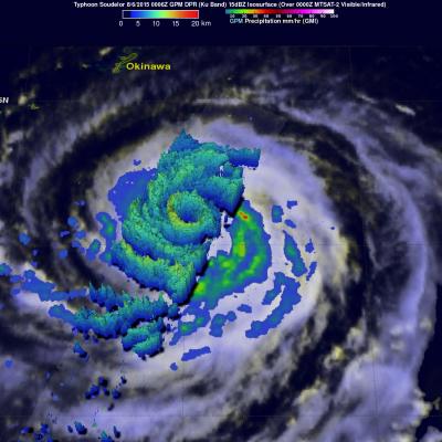
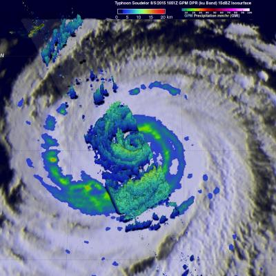
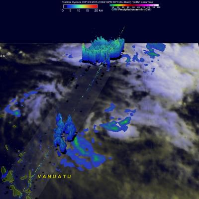
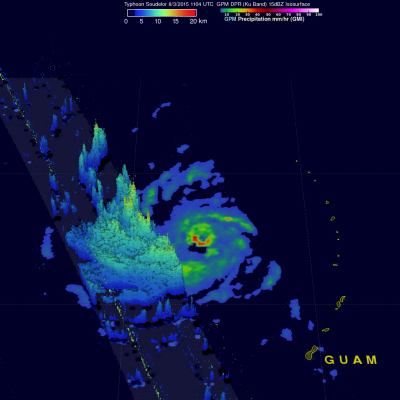
PPS Web Services still Temporarily Slow or Intermittent

PPS web services are still experiencing intermittent unavailability and/or slow response times and our staff is working to resolve this problem as soon as possible. This problem impacts access to various PPS web services: ftp://arthurhou.pps.eosdis.nasa.gov (GPM FTP data) http://pps.gsfc.nasa.gov (PPS home page) https://storm-pps.gsfc.nasa.gov (PPS STORM) http://registration.pps.eosdis.nasa.gov (PPS GPM registration) http://ceospc.gsfc.nasa.gov GPM near real time operations and data distribution as well as PPS GPM operations are NOT affected. Only the PPS GPM data distribution is affected. We

GPM Has Another Good Look At Soudelor

Typhoon Soudelor's winds had dropped to 95 kts ( 109 mph) when the GPM core observatory satellite had another excellent daytime view on August 6, 2015 at 0006 UTC. GPM's Dual-Frequency Precipitation Radar (DPR) data showed that Soudelor had heavy rainfall in an inner eye wall and also in a much larger replacement outer eye wall. The heaviest rain found by GPM was dropping at a rate of close to 70 mm (2.4 inches) per hour in a strong feeder band spiraling in on the southwestern side of the typhoon. Radar reflectivity data from GPM's Dual-Frequency Precipitation Radar (DPR) data were also used

Typhoon Soudelor Threatens Taiwan And China

Typhoon Soudelor's sustained winds were about 105 kts ( about 121 mph) when the GPM core observatory satellite flew above on August 5, 2015 at 1051 UTC. A rainfall analysis was made from data collected from GPM's Microwave Imager (GMI) and Dual-Frequency Precipitation Radar (DPR) instruments. This analysis showed that Soudelor was very large and had a well defined eye. Intense feeder bands are shown spiraling into the center. Three dimensional radar reflectivity data GPM's DPR (ku Band) were used to construct a simulated cross section through typhoon Soudelor's center. This view from the south

PPS Network Instability

Presently, PPS web services are experiencing intermittent unavailability and/or slow response times. PPS is aware of this issue and our System Programmers are working diligently to correct these issues. The current anomaly affects our arthurhou server which include the PPS Public site http://pps.gsfc.nasa.gov/ , FTP services, STORM: https://storm.pps.eosdis.nasa.gov/ and THOR (THOR online) , etc. We hope to have all these services restored to normal as soon as possible and will keep you informed as the situation changes. We regret any inconvenience that this may cause and kindly appreciate

GPM Views Rare Southern Hemisphere Tropical Cyclone

It is a little unusual to see a tropical cyclone forming in the southern Pacific Ocean this time of the year but tropical cyclone 01P formed northeast of Vanuatu recently. The GPM core observatory satellite saw Tropical Cyclone 01P on Monday August 3, 2015 at 2106Z (about 9:06 local time). GPM's Microwave Imager (GMI) found rain falling at a rate of over 30 mm (1.2 inches) per hour in a small area of showers near the center of the tropical cyclone. A 3-D view constructed from GPM's Dual-Frequency Precipitation Radar (DPR) instrument (Ku band) showed that some showers located between the

Super Typhoon Soudelor Threatens Taiwan And China

The GPM core observatory satellite flew almost directly over super typhoon Soudelor in the western Pacific Ocean on August 3, 2015 at 1104 UTC. At that time Super Typhoon Soudelor had winds of about 125kts (139 mph) and is predicted by the Joint Typhoon Warning Center (JTWC) to become even more powerful tomorrow while headed toward northern Taiwan. GPM's Microwave Imager (GMI) had a very good view of heavy rainfall associated with Soudelor. GMI showed that the super typhoon had rain falling at a rate of over 58 mm (2.3 inches) per hour in the southern side of Soudelor's well defined eye. Radar

Weakening Hurricane Guillermo Nears Hawaiian Islands

Hurricane Guillermo was a category one hurricane with wind speeds of about 75 kts (86 mph) when the GPM core observatory satellite flew over on Sunday August 2, 2015 at 1901 UTC. Rainfall was measured by GPM's Microwave Imager (GMI) and Dual-Frequency Precipitation Radar (DPR) instruments falling at a rate of over 61 mm (2.4 inches) per hour northeast of Guillermo's eye. GPM's DPR found rain falling at a rate of over 91 mm (3.6 inches) per hour in a feeder band spiraling into Guillermo from the southeast. GPM radar reflectivity data (Ku band) were used to show a 3-D cross section through the
A Tale of Two Extremes: Rainfall Across the US
The United States has seen a tale of two extremes this year, with drenching rains in the eastern half of the country and persistent drought in the west. A new visualization of rainfall data collected from space shows the stark contrast between east and west for the first half of 2015. The accumulated precipitation product visualized here begins on Jan. 1, 2015, and runs through July 16, 2015. This visualization shows the heavy rainfall throughout Northern Texas and across Oklahoma as well as the drought in Southern California. Credits: NASA Goddard's Scientific Visualization Studio Download...

Hurricane Guillermo Heads Toward Hawaii

On July 29, 2015 tropical depression Nine-E formed in the eastern Pacific Ocean well southwest of the southern tip of Baja California. The tropical depression was in an area of warm ocean water which helped the tropical cyclone blossom into tropical storm Guillermo early on July 30, 2015. Guillermo is a hurricane today and is headed over the open waters of the Pacific Ocean toward the west-northwest. In about a week Guillermo may affect the Hawaiian Islands as a tropical storm. On July 31, 2015 at 0556 UTC Guillermo was about 319 km (~590 Nautical Miles) east-southeast of Hilo, Hawaii when the