GPM

GPM content

The GPM Validation Network and Evaluation of Satellite-Based Retrievals of the Rain Drop Size Distribution

Submitted by LisaN on
Publication Year
Authors
Gatlin, P., W. A Petersen, J. L. Pippitt, T. A Berendes, D. B. Wolff, and A. Tokay
Journal
atmosphere
Volume
11(9)
Page Numbers
1010
DOI
10.3390/atmos11091010
Mission Affiliation
Major Category
PPS is Releasing New METOPC MHS GPM L1C and GPROF METOPC MHS GPM Level 2 and Level 3 Data and Climatology Products

Commencing today, Wednesday January 29, 2020, PPS is producing and releasing new satellite METOPC MHS GPM Level 1C and GPROF METOPC MHS GPM Level 2 and Level 3 data and Climatology Products V05. These new products will have the starting date of December 11, 2019. GPROF METOPC MHS GPM Level 2 and Level 3 Climatology products will be produced once the ERA5 input data is received for December 2019. See the tables below for pertinent details. List of data types, product versions and start dates +---------------------+----------------+---------------------+ | DataType | ProductVersion | StartDate |

GPM Views Southeast Snowstorm

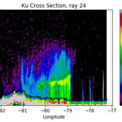
On February 20th and 21st, 2020, a winter storm brought the seasons largest snowfall to much of North Carolina and southern Virginia. The highest snow totals of 3-5 inches (7-12 cm) were located in northeast NC and southeast VA. GPM's radar captured captured the reflectivities shown in this cross-section as it flew over the snow storm on February 20th, with snow and frozen precipitation shown in blue and purple and rain shown in green and yellow. The melting layer marks the transition from snow to rain and slopes upward 2-3 km from central NC to the coast. These raw reflectivity measurements

GPM Measures Heavy Rainfall from "The Dragon" Cyclonic Storm System in the Middle East

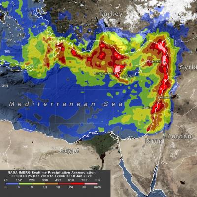
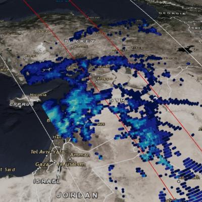
GPM observed the early stages of a strong cyclonic system that developed over northern Africa just off the southern Mediterranean coast on March 11, 2020. The GMI measured heavy rain rates over some parts of Egypt, including the region around Cairo. View fullscreen By March 12, 2020, the cyclonic system that developed over northern Africa had intensified and was nicknamed 'The Dragon' on social media and news outlets, as it caused severe flooding in northern Egypt. Both the GMI and the DPR measured heavy rain rates across two of the storm's bands in this GPM overflight. View fullscreen On

Tropical Storm Imelda Brings Flooding Rain To Texas

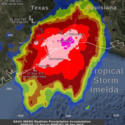
By Friday morning, September 20, the rainfall from the remnant of Tropical Storm Imelda had increased to over 24 inches in some areas near the Gulf of Mexico coast between Beaumont and Houston, Texas. This rainfall was in excess of what had been forecasted a few days earlier and was due to Imelda's forward motion ceasing for approximately 24 hours between Wednesday and Thursday afternoon. The image shows, with large "L" symbols, the location estimated by the National Hurricane Center for Imelda's low-pressure center of rotation at various times over the past three days. This near-realtime rain

GPM IMERG Measures Hurricane Dorian's Rainfall from the Caribbean to Canada

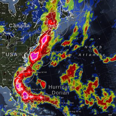
Hurricane Dorian (2019) brought heavy rain to the Caribbean, along the US East Coast, and up to Canada. NASA satellite-based precipitation estimates tracked the storm throughout its lifetime, as shown by the sequence of images below. September 3, 2019: Hurricane Dorian over Grand Bahama and Abaco Islands In the early hours of Tuesday, September 3, Hurricane Dorian had been stationary over the island of Grand Bahama for 18 hours, most of the time as a category 5 hurricane. Storm-total rain accumulation over parts of Grand Bahama and Abaco islands have exceeded 24 inches according to NASA