Resources

Resources content

GPM flying over Earth with a data swath visualized.
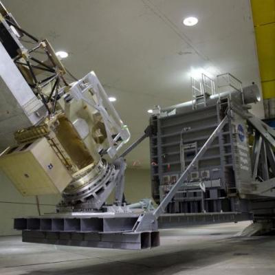
NASA technicians spun the GPM satellite up to just over 10 RPM in Goddard Space Flight Center’s High-Capacity Centrifuge facility March 31 2011. Put Some Spin On It If you've ever taken a fast curve in a car, you've felt your body pushed outward, away from the curve. That outward push is centrifugal force, and the faster you turn, the more it pushes you away from the center. Spinning on the centrifuge does the same thing to the satellite -- except the centrifugal forces are a lot bigger -- capable of going up to 30 times the force of gravity, or "g's." GPM's test went up to seven g's. But...
GPM on the High Capacity Centrifuge
In the clean room at NASA Goddard Space Flight Center in Greenbelt Md., the Global Precipitation Measurement (GPM) mission's Core satellite is steadily taking shape. Set to measure rainfall worldwide after launch in 2014, GPM's two solar panels are the latest components currently undergoing rigorous testing before being integrated with the spacecraft, a process that began seven months ago when the main structural elements went on an unusual ride. GPM moves from the clean room to the test chamber on a dolly without wheels. Compressed air is pumped out under airpads that float the Spacecraft on...
Document Description

Excerpt:

Document Description

During the GPM pre-launch period physically-based snowfall retrieval algorithms are in an active phase of development. Further refinement and testing of these emerging algorithms requires the collection of targeted ground-validation datasets in snowing environments. This document describes a field campaign effort designed to provide both new datasets and physical insights related to the snowfall process- especially as they relate to the incorporation of appropriate physics into GPM snowfall retrieval algorithms.

Document Description

This document describes the algorithm and processing sequence for the Integrated Multi-satellitE Retrievals for GPM (IMERG).  This algorithm is intended to intercalibrate, merge, and interpolate “all” satellite microwave precipitation estimates, together with microwave-calibrated infrared (IR) satellite estimates, precipitation gauge analyses, and potentially other precipitation estimators at fine time and space scales for the TRMM and GPM eras over the entire globe.  The system is run several times for each observation time, first giving a quick estimate and successively providin

Date Last Updated
May 15th, 2022
Document Description

This ATBD describes the Global Precipitation Measurement (GPM) passive microwave rainfall algorithm, which is a parametric algorithm used to serve all GPM constellation radiometers. The output parameters of the algorithm are enumerated in Table 1. It is based upon the concept that the GPM core satellite, with its Dual Frequency Radar (DPR) and GPM Microwave Imager (GMI), will be used to build a consistent a-priori database of cloud and precipitation profiles to help constrain possible solutions from the constellation radiometers.

File Downloads
Date Last Updated
April 1st, 2016
Document Description

Level 1C (L1C) algorithms are a collection of algorithms that produce common calibrated brightness temperature products for the Global Precipitation Measurement (GPM) Core and Constellation satellites.

This document describes the GPM Level 1C algorithms. It consists of physical and mathematical bases for orbitization, satellite intercalibration, and quality control, as well as the software architecture and implementation for the Level 1C algorithms.

File Downloads
Document Description

The GPM Combined Radar-Radiometer Algorithm performs two basic functions: first, it provides, in principle, the most accurate, high resolution estimates of surface rainfall rate and precipitation vertical precipitation distributions that can be achieved from a spaceborne platform, and it is therefore valuable for applications where information regarding instantaneous storm structure are vital.

Date Last Updated
December 17th, 2021
Document Description

This document describes the basic idea of DPR data processing. It was originally written for the algorithm used in the at-launch version (V03). The algorithm has been modified and improved since then. Although the basic idea of data processing remains the same, the actual flow of processing, in particular that in the solver module, has changed substantially. As a result, some part of description in Section 3.1 may not be relevant any more.

File Downloads
Document Description

Observations of the space-time variability of precipitation around the globe are imperative for understanding how climate change affects the global energy and water cycle (GWEC) in terms of changes in regional precipitation characteristics (type, frequency, intensity), as well as extreme hydrologic events, such as floods and droughts. The GWEC is driven by a host of complex processes and interactions, many of which are not yet well understood. Precipitation, which converts atmospheric water vapor into rain and snow, is a central element of the GWEC.