TRMM

Content which is associated solely with the Tropical Rainfall Measuring Mission.

TRMM wins the 2016 Group Pecora Award
The William T. Pecora Award is presented annually to individuals or groups that make outstanding contributions toward understanding the Earth by means of remote sensing. The award is sponsored jointly by the Department of the Interior (DOI) and the National Aeronautics and Space Administration (NASA). The award was established in 1974 to honor the memory of Dr. William T. Pecora, former Director of the U.S. Geological Survey and Under Secretary, Department of the Interior. Dr. Pecora was a motivating force behind the establishment of a program for civil remote sensing of the Earth from space...

TRMM Spacecraft Re-enters Over Tropics

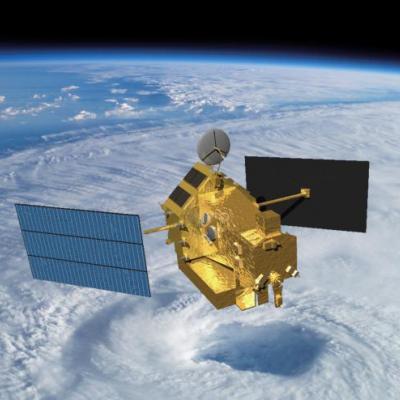
The Tropical Rainfall Measuring Mission (TRMM) spacecraft re-entered the Earth’s atmosphere on June 15, 2015, at 11:55 p.m. EDT, over the South Indian Ocean, according to the U.S. Strategic Command’s Joint Functional Component Command for Space through the Joint Space Operations Center (JSpOC). The U.S. Space Surveillance Network, operated by the Defense Department's JSpOC, had been closely monitoring TRMM’s descent since the mission was ended in April. Most of the spacecraft was expected to burn up in the atmosphere during its uncontrolled re-entry. This U.S. Air Force map shows the
TRMM Spacecraft Debris to Re-Enter
June 16, 2015, Update: The Tropical Rainfall Measuring Mission (TRMM) spacecraft re-entered the Earth’s atmosphere on June 15, 2015, at 11:55 p.m. EDT, over the South Indian Ocean, according to the U.S. Strategic Command’s Joint Functional Component Command for Space through the Joint Space Operations Center (JSpOC). The U.S. Space Surveillance Network, operated by the Defense Department's JSpOC, had been closely monitoring TRMM’s descent since the mission was ended in April. Most of the spacecraft was expected to burn up in the atmosphere during its uncontrolled re-entry. This U.S. Air Force...
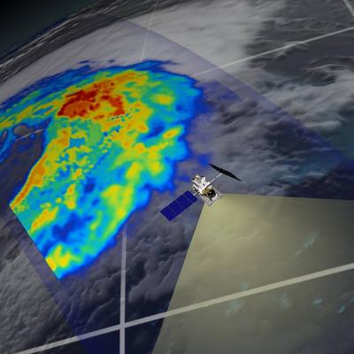
GPM flying over Earth with a data swath visualized.
This page has been moved to http://pmm.nasa.gov/extreme-weather. You will be automatically redirected in 10 seconds if your browser supports Javascript. Please update your bookmarks and links to the new URL.

GPM Views Typhoon Dolphin Headed For Guam

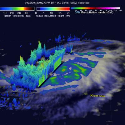
Typhoon Dolphin formed south of Pohnpei in the western Pacific Ocean on May 7, 2015. Dolphin's power has oscillated from a weak tropical depression to typhoon intensity over the past five days. Dolphin is now an intensifying typhoon headed westward. The GPM core observatory satellite flew over Dolphin on May 12, 2015 at 2301 UTC. At that time Dolphin's wind speeds were estimated at about 65 kts (75 mph). Rainfall collected by GPM's Microwave Imager (GMI) showed that rain was falling at a rate of over 47 mm (1.9 inches) per hour in a feeder band to the southeast of Dolphin's eye. Ku Band data

Ana Becomes First 2015 Atlantic Tropical Storm & Weakens Ashore

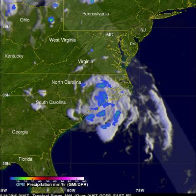
On May 9, 2015 at 1626 UTC ( 12:26 PM EDT) the GPM satellite flew over when Ana was making the change from subtropical storm to tropical storm. Convective storms near the inner-core region were warming the center of the storm with heat generated by condensation. GPM's Microwave Imager (GMI) measured rain falling at at rate of over 58.7 (2.31 inches) per hour in these convective storms near ANA's center. The lighter swath to the west of Ana's center shows the area viewed by GPM's Ku/Ka-band Dual-frequency Precipitation Radar (DPR). On Sunday morning (May 10, 2015) Tropical storm ANA dropped

GPM Flys Above Subtropical Storm Ana

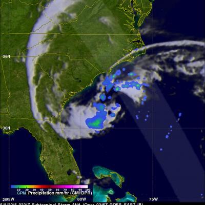
During the past few days subtropical storm Ana was developing off the southeastern coast of the United States. Yesterday and today the GPM core observatory satellite had two good views of subtropical storm Ana. The image above shows the developing subtropical storm on May 7, 2015 at 1636 UTC (12:36 PM EDT). This GPM pass occurred a little over 10 hours before the National Hurricane Center (NHC) issued their first advisory at 0300 UTC ( 11:00 PM EDT). This image shows rainfall derived from GPM's Ku/Ka-band Dual-frequency Precipitation Radar (DPR) and a multi-channel GPM Microwave Imager (GMI)

Typhoon Noul Beginning to Strengthen in the West Pacific

Since its formation as a tropical depression 3 days ago, Typhoon Noul has taken on a general westward motion while steadily working its way across the central-west Pacific. During this time, the system passed over Yap where it brought heavy rain and strong gusty winds. Thus far, Noul has been only slowly strengthening, becoming a minimal typhoon just one day ago. That appears likely to change, however, as the system now seems poised to intensify as it passes well north of Palau in the genearal direction of the Philippines. NASA's GPM Core observatory satellite captured this image of Noul as it

NASA IMERG Sees Australia's Bicoastal Rainfall

The rainfall accumulation analysis above was computed from data generated by the Integrated Multi-satellite Retrievals for GPM (IMERG) during the period from April 28 to May 3, 2015. During this period IMERG algorithms continuously merged and interpolated satellite passive microwave precipitation estimates and microwave-calibrated infrared (IR) satellite estimates over the entire globe. Rainfall from cyclone Quang fell over the west coast and a non-tropical system pounded the east coast of Australia simultaneously during the past weekend. Cyclone Quang formed in the South Indian Ocean

Recent 3B41RT and 3B42RT Files Reprocessed

NOAA has reprocessed the global IR data for 10 UTC 26 April through 14 UTC 27 April due to dropped images, and all 3B41RT and 3B42RT files for this time period have been reprocessed by PPS and are now available: 3B41RT.2015042610.7.bin.gz through 3B41RT.2015042714.7.bin.gz 3B42RT.2015042612.7.bin.gz through 3B42RT.2015042715.7.bin.gz Such partial dropouts in the IR data result in somewhat lower quality for IMERG Early and Late Runs, but are not cause for reprocessing.