

NASA Satellites Track Zebra Crossing
Botswana's Okavango Delta and the Makgadikgadi Salt Pans are two ends of a 360-mile round trip zebra migration, the second longest on Earth. In this animation, shades of red show dry areas, green represents vegetation, and the dots show GPS tracked zebras. The zebras begin at the Okavango Delta in late September. After the dry Southern hemisphere winter, November rains signal it is time to begin their two-week journey to the Salt Pans.
TRMM Sees Powerful Typhoon Utor As It Neared China
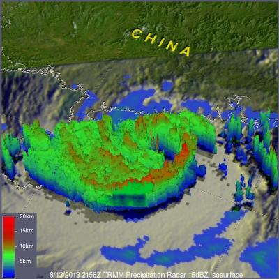
Torrential rain and powerful winds accompanied typhoon Utor when it came ashore in southern China's Guangdong province. The TRMM satellite flew above as typhoon Utor was headed toward southern China on August 13, 2013 at 2156 UTC. At the time of this TRMM pass typhoon Utor was a powerful typhoon with wind speeds reaching over 85kts (~98mph). A rainfall analysis from TRMM's Microwave Imager (TMI) and Precipitation Radar (PR) instruments is shown overlaid on an infrared image from TRMM's Visible and InfraRed Scanner (VIRS). Bands of intense rainfall are shown spiraling into the eye that was
Typhoon UTOR Hits The Philippines
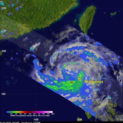
A category four typhoon called UTOR hit the Philippines with wind speeds of about 120kts (~138 mph). It has been reported that at least one person was killed and 20 fishermen are missing. Landslides are also likely due to heavy rainfall that is occurring over the Philippine's rugged mountainous terrain. The image above used data collected by the TRMM satellite when it passed over UTOR on August 12, 2013 at 0621 UTC as it was exiting the Philippines into the South China Sea. TRMM's Microwave Imager (TMI) and Precipitation Radar (PR) data are shown overlaid on a combination Infrared/Visible
TRMM Sees Weakening Henriette
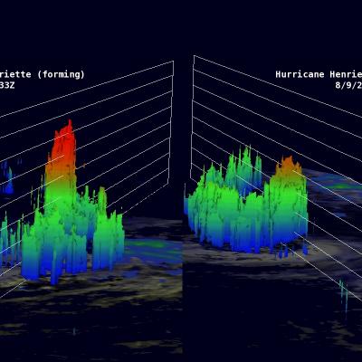
As predicted by the National Hurricane Center (NHC), hurricane Henriette has started a weakening trend. The TRMM satellite flew over Henriette again on August 9, 2013 at 0122 UTC (~ 4 PM local time). The image above shows a comparison between this latest orbit and another visible image from TRMM's previous orbit on August 8, 2013 at 1709 UTC. The eye that was apparent in the previous image was no longer distinct in the latest TRMM pass. The image of the right shows that rain was still falling at a rate of over 161mm/hr (~6.3 inches) near the center of the hurricane. The image above shows a
Hurricane Henriette Still Strong
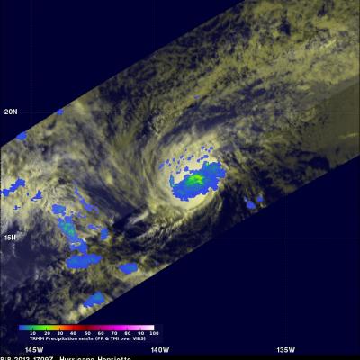
The TRMM satellite saw hurricane Henriette again on August 8, 2013 at 1709UTC (~8:09 AM Local Time). Henriette is predicted to start weakening tomorrow but with this TRMM pass the hurricane's eye could still be easily found on the TRMM visible (VIRS) image on the left. Henriette was small but TRMM's Microwave Imager (TMI) and Precipitation Radar (PR) showed that moderate to heavy rainfall was occurring in an area around the center of the hurricane.
Hurricane Henriette To Move Over Colder Waters
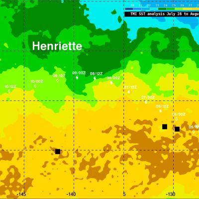
Hurricane Henriette, located a little over 1,770km (~1100 miles) east of Hawaii, was still intense with winds of 90kts (~103.5 mph) this morning. The National Hurricane Center (NHC) predicts that Henriette will weaken tomorrow as it moves over cooler waters and encounters west-southwesterly wind shear. Henriette's track was overlaid on a Sea Surface Temperature (SST) analysis that was derived from observations by the TRMM Microwave Imager (TMI) radiometer. Sea Surface temperatures have to be warmer than 26 °C for tropical cyclones to survive and this analysis indicates that hurricane Henriette
Hurricane Henriette
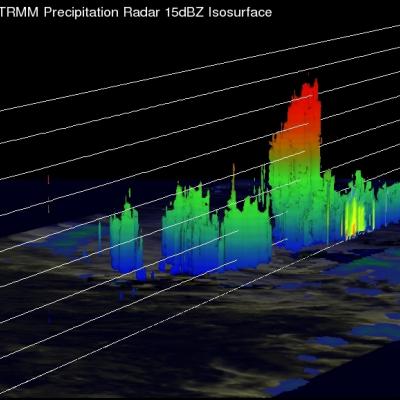
The TRMM satellite flew over the eastern Pacific Ocean on August 6, 2013 0233 UTC (~5:33 PM local time) collecting data for the low sun angle views of hurricane Henriette shown here. The Visible/Infrared image on the left shows the shadows cast by towering thunderstorms on the northeastern side of Henriette's forming eye wall. The image on the right shows the same image with rainfall derived from TRMM's Microwave Imager (TMI) and Precipitation Radar (PR) instruments overlaid. TRMM's PR instrument measured rain falling at the rate of over 55.46mm/hr (~2.2 inches) per hour in this towering
Hawaii Says Aloha To Flossie
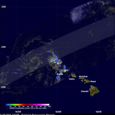
The TRMM satellite had an excellent day time view of dissipating tropical depression Flossie as it was moving to the northwest of the Hawaiian Islands on July 30, 2013 at 2348 UTC (1:38 PM HAST). An analysis of rainfall from TRMM's Microwave Imager (TMI) and Precipitation Radar (PR) is shown overlaid on a combination visible and infrared image from TRMM's Visible and InfraRed Scanner (VIRS) instrument. This analysis shows that very little precipitation was then occurring near the center of the weakening tropical cyclone's circulation. The most intense rain was found by TRMM to be falling at a
Weakening Tropical Storm Flossie Hits Hawaiian Islands
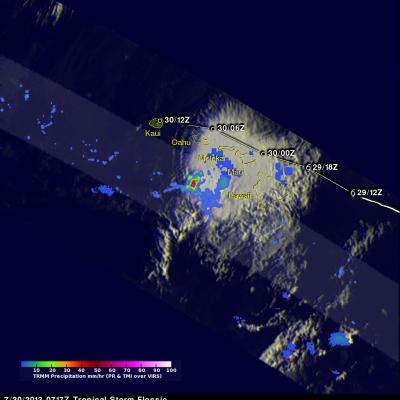
Weakening tropical storm Flossie had lightning with heavy rain and winds as it drove through the Hawaiian islands. The TRMM satellite flew above tropical depression Flossie on July 30, 2013 at 0717 UTC (July 29, 2013 at 9:17 PM HAST). TRMM's Microwave Imager (TMI) and Precipitation Radar (PR) instruments showed that the heaviest rain at that time was located to the southwest of the Islands and was falling at a rate of over 88mm/hr (3.5 inches). Flossie's approximate locations with appropriate tropical cyclone symbols are shown overlaid in white. TRMM's Precipitation Radar is able to separate