TRMM

Content which is associated solely with the Tropical Rainfall Measuring Mission.

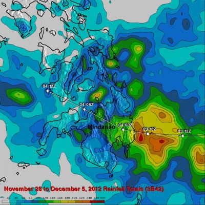
Intensifying Tropical Cyclone Moving Over Samoan Islands

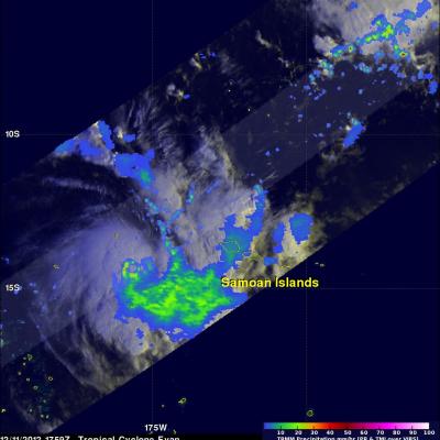
The TRMM satellite passed above an intensifying tropical cyclone in the South Pacific Ocean called Evan on December 11, 2012 at 1759 UTC. Evan is predicted to attain hurricane force winds on December 13, 2012 when it is moving through the Samoan Islands. An analysis of Evan's rainfall from TRMM's Precipitation Radar (PR) and Microwave Imager (TMI) shows that Evan already had an eye-like structure at the time of this TRMM orbit. Click here To a simulated flyby courtesy of TRMM Precipitation Radar (PR) data. TRMM's 3-D Precipitation Radar (PR) data were used to measure the heights of Evan's

Typhoon Bopha's Heavy Rain Over Mindanao

High winds, flooding and landslides from heavy rains with typhoon Bopha have caused over 300 deaths in the southern Philippines. The Tropical Rainfall Measuring Mission (TRMM) satellite's primary mission is the of measurement of rainfall in the Tropics. The TRMM-based, near-real time Multi-satellite Precipitation Analysis (MPA) at the NASA Goddard Space Flight Center monitors rainfall over the global Tropics. MPA rainfall totals are shown here for the period from November 28 to December 5, 2012 when typhoon Bopha was moving through the southern Philippines. Typhoon Bopha's track is shown

Typhoon Bopha Devastates Mindanao, Moves Into Sulu Sea

Typhoon Bopha pounded the Philippines with high winds and drenching rain when it crossed the island of Mindanao today. Numerous deaths and wide spread destruction have been reported. The TRMM satellite had a good view of Bopha moving into the Sulu Sea when it flew over on December 4, 2012 at 1420 UTC. This TRMM pass showed that Bopha still had good organization but Mindanao's rugged terrain had taken it's toll. Bopha's eye had been disrupted but TRMM Precipitation Radar (PR) data revealed that very heavy rain was still falling at a rate of over 85 mm/hr (~3.5 inches) near the center of the

Typhoon Bopha Threatens Philippines

At 0347 UTC today the TRMM satellite flew above a dangerous typhoon in the western Pacific Ocean called Bopha that is a threat to the Philippines. Bopha is predicted by the Joint Typhoon Warning Center (JTWC) to hit the island of Mindinao in the Philippines with winds of 135 kts (155 mph) later today. The first image shows a satellite view of typhoon Bofa with rainfall from TRMM's Microwave Imager (TMI) and Precipitation Radar (PR) instruments overlaid on a visible/infrared image from TRMM's Visible and InfraRed Scanner (VIRS). This analysis shows that Bopha had a well defined eye with very

TRMM Sees Tornado Spawning Thunderstorms

In the United States tornadoes develop most often in the spring when warm moist unstable air accompanies strong fronts and fluctuating upper-air systems. There is a also a slight increase in tornado activity in late October and November. Tornadoes form least often in December and January so the tornadoes that occurred yesterday over the south-eastern United States were unusual. The TRMM satellite was flying over on December 10, 2012 at 1743 UTC (12:43 PM EST) and captured data showing tornado spawning thunderstorms within a frontal system moving through Louisiana, Mississippi, Alabama, Georgia

2012 Western Atlantic Tropical Cyclone Rainfall Measured From Space

The TRMM satellite has now been making highly accurate measurements of rainfall from space for fifteen years. TRMM can be used to calibrate rainfall estimates from other additional satellites. Those Rainfall data (3B42) are routinely created and stored at the Goddard Space Flight Center. The TRMM-based, near-real time Multi-satellite Precipitation Analysis (TMPA) at the NASA Goddard Space Flight Center can be used to analyze rainfall over a wide portion of the globe. The TMPA analysis above shows the estimated amount of rain contributed by named tropical cyclones over the western Atlantic in

TRMM Sees Tropical Storm Bofa

The TRMM satellite flew above tropical storm Bofa on November 27, 2012 at 1601 UTC and collected data used in the image above. TRMM showed that tropical storm Bofa had an area of very intense convective storms near the center of circulation. TRMM's Microwave Imager (TMI) and Precipitation Radar (PR) data revealed that rain was falling at a rate of over 70mm/hr (~1.75 inches) in that area. TRMM's Precipitation Radar (PR) also showed that powerful storms in the area of the developing eye wall were reaching to heights of about 17km (~10.6 miles). Click here to see a simulated flyby above Bofa
Aerial photo of 2010 landslide in Gansu, China
By Lisa-Natalie Anjozian , NASA Goddard Space Flight Center Original www.nasa.gov Press Release (published 11/27/12) A NASA study using TRMM satellite data revealed that the year 2010 was a particularly bad year for landslides around the world. Around midnight on August 8, 2010, a violent surge of loosened earth roared down mountain slopes and slammed into quietly sleeping neighborhoods in Zhouqu County in Gansu, China. The catastrophic mudslides—the deadliest in decades according to state media—buried some areas under as much as 23 feet (7 meters) of suffocating sludge. 1,765 people died...
TRMM reign of rain screenshot
By Ellen Gray , NASA Goddard Space Flight Center Original www.nasa.gov Article (published 11/27/12) When it rains it pours, goes the saying, and for the last 15 years, the data on tropical rainfall have poured in. NASA's Tropical Rainfall Measuring Mission (TRMM) was launched on Nov. 27, 1997, and for the last decade and a half has enabled precipitation science that has had far reaching applications across the globe. TRMM Project Scientist Scott Braun looks back at the legacy of the Tropical Rainfall Measuring Mission and a few of the major scientific milestones the satellite has helped...

TRMM at 15: The Reign of Rain

Submitted by JacobAdmin on
Video Embed

When it rains it pours, goes the saying, and for the last 15 years, the data on tropical rainfall have poured in. NASA's Tropical Rainfall Measuring Mission (TRMM) was launched on Nov. 27, 1997, and for the last decade and a half has enabled precipitation science that has had far reaching applications across the globe.