2013 New England Blizzard
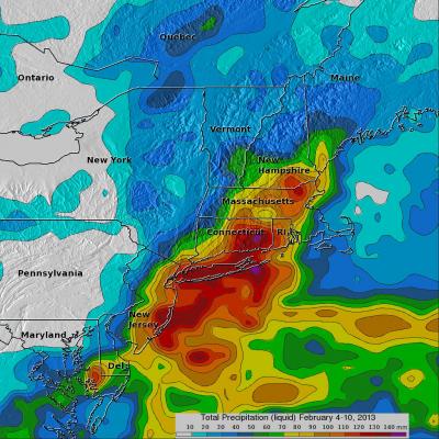
As accurately predicted by the National Weather Service, a blizzard dropped extreme amounts of snow over the North-East beginning on February 8, 2013. An amazing snow depth of 38 inches (~965 mm) was reported in Milford, Connecticut. The blizzard was reportedly the cause of at least 14 deaths in the United States and Canada. The TRMM-based, near-real time Multi-satellite Precipitation Analysis (TMPA) at the NASA Goddard Space Flight Center is used to estimate precipitation for much of the globe. TMPA (liquid) precipitation totals (mm) are shown for the week from February 4-10 when the blizzard