Retroprocessed IMERG V07 Early and Late Run Data for Jan 1, 1998 through May 2000 Now Available JacobAdmin Tue, 12/10/2024
The PPS has completed retroprocessing IMERG V07 products for Jan. 1, 1998 to May 31, 2000. Both the Early and Late standard HDF product and the GIS products are available on the "jsimpson" GPM near real-time file servers. Please visit our data directory for a full list of product downloads and documentation. With this retroprocessing now complete, IMERG V07 products are now available from January 1998 through the present.
New Tool for Visualizing IMERG Data JacobAdmin Mon, 11/25/2024
ANNOUNCING a NEW IMERG Web Visualization Tool: RAIN-Global (Regional Animations of IMERG in Near-realtime - Global Edition): https://storm.pps.eosdis.nasa.gov/storm/outreach/RAIN-Global.html RAIN-Global is the next-generation, 3D global, fully interactive upgrade to RAIN, a web interface that displays recent 7-day animations of precipitation rates and accumulations from IMERG-Late data, as well as cloudiness from geosynchronous IR data. Animations are updated daily for the 7-day period ending on the prior day and are available for the past 30 days. New features include: Use your mouse or
Group photo of attendees of the 2024 PMM Science Team Meeting.
Above image: Attendees of the 2024 PMM Science Team Meeting.
IMERG V07 Early and Late Run Extreme Values in October 2024 JacobAdmin Tue, 11/12/2024
Regions of unrealistically high values appeared in the IMERG Early and Late files starting around 00:00 UTC on 17 October 2024. Upon investigation, GPM scientists detected an operational problem on the GPM Core Observatory around 15 October 2024 that caused some corrupted CORRA data to be added to the CORRA-GMI calibration accumulator files for the IMERG Early and Late Runs. These anomalous data affected the calibration when it was next updated (on 17 October 2024). Repaired calibration files were applied at 06:00 UTC on 2 November 2024. The time spans of the unrealistic calibrations in Early
top image for Sahara 2024
Most people live in places where it rains much more often than it does in the Sahara Desert. For this reason, it can be challenging to make sense of news reports of major storms in the Sahara. NASA satellite data and rainfall statistics can give the needed context. Below is a discussion of three news stories about rainfall in or near the Sahara Desert during August and September 2024. These news stories described storm runoff, infrastructure damage, and the rain's impact on the ecosystems at the edge of the desert. Areas with significant impacts are shown in green in Figure 1. Figure 1. A map
Screenshot of IMERG rain rates on October 29, 2024
During the 10-day period from Oct. 26 through Nov. 4, 2024, parts of central-eastern and southern Spain saw unusually heavy flooding that resulted in heavy infrastructure damage and over 200 fatalities, according to the Associated Press . In this animation, NASA’s IMERG multi-satellite data product shows estimated rain rates (blue/yellow shading) and accumulations (green/purple shading) from the flooding rainfall. Cloudiness is also shown in white/gray shading, from geosynchronous infrared satellite observations. Download video (right-click -> "Save As") The flooding was caused by heavy
Thumbnail
For the third consecutive year, NASA’s Global Precipitation Measurement Mission applications team and University of Coimbra’s Earth and Space Science Center (CITEUC Portugal) collaborated to host the GPM Mentorship Program. The 2024 initiative built on previous years' successes, supporting new users from established and underrepresented user communities and providing a tailored hands-on learning experience in using GPM data for applications. It gave participants an overview of state-of-the-art GPM satellite-based precipitation estimates and provided users with examples of applying GPM data to
Reduced Data Quality of IMERG Early and Late HDF Files JacobAdmin Mon, 10/21/2024
On 18 October 2024 PPS received a corrupted IR file for 15:00 UTC, which caused all subsequent IR processing to fail and not contribute to the Early Run from 16:00 UTC on 18 October until 05:00 UTC on 20 October, and to the Late Run from 16:00 UTC on 18 October until 20:00 UTC on October 19. Subsequently, PPS manually skipped past the defective IR data file and ran all the IR data that were missed, and then reran both Early and Late for the periods listed above. These rerun products have replaced the earlier products on the fileserver. Please note the out-of-order file times to confirm which
Map IMERG rainfall totals from Milton.
While the GPM Core Observatory’s instruments show exceptional detail in Milton’s rainfall structure in several overpasses throughout the week, the IMERG global multi-satellite product provides a broader overview of precipitation along Milton’s track as a continuous picture from development through landfall. Download this video (right-click -> "save as") The above animation shows IMERG precipitation rates (in blue/yellow shading) and accumulations (in green/purple shading) from Oct. 5-10, 2024. Cloudiness is shown in shades of white/gray using infrared geosynchronous satellite data. While
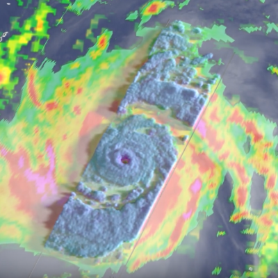
GPM data shows precipitation within Hurricane Milton over the Gulf of Mexico on Oct. 7, 2024.
Updated Oct. 10, 2024 Click here for a visualization of IMERG precipitations and totals from Hurricane Milton. After forming in the Bay of Campeche, Hurricane Milton underwent a remarkable period of rapid intensification with its central pressure falling from 1007 mb (29.74 inches of mercury, inHg) at 11:00 a.m. EDT Oct. 5 to 897 mb (26.49 inHg) at 8:00 p.m. EDT on Oct. 7. At this time Milton became the fifth most intense hurricane in the Atlantic Basin on record in terms of central pressure, just behind Hurricane Rita (2005) on that list, and only the sixth storm in the Atlantic to have a