Tropical Storm Edouard forms in the Atlantic

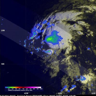
The formation of Tropical Storm Edouard in the central Atlantic marks the climatological peak of the Atlantic hurricane season in what has so far been a rather average season in terms of the number of storms. Edouard became the fifth named storm of the season after forming overnight in the central Atlantic about 1645 km (~1020 miles) west of the Cape Verde Islands. In a typical season there are about 10 named storms and 6 hurricanes. So far this year, halfway through the season, there have been 5 named storms and 3 hurricanes, but none have posed a major threat to the US, and there have been

Tropical Storm Odile Forms

The hurricane season continues to be active in the eastern Pacific Ocean. Hurricane Norbert dissipated a few days ago and then tropical storm Odile formed yesterday (September 10, 2014) in the same area where Norbert formed. The TRMM satellite flew over tropical storm Odile on September 11, 2014 at 0418 UTC and collected data used in the images above. The first image shows a rainfall analysis made from TRMM's Microwave Imager (TMI) and Precipitation Radar (PR) data overlaid on a 0430 UTC GOES-WEST enhanced infrared image. TRMM PR found that Odile was dropping rain at the extreme rate of over

Moisture From Norbert Spreads Heavy Rain Over Southwest

The TRMM satellite flew above the post-tropical cyclone remnants of former hurricane Norbert on September 8, 2014 at 0849 UTC (1:49 AM PDT). This image shows TRMM rainfall derived from the Microwave Imager (TMI) and Precipitation Radar (PR) instruments overlaid on a 0900 UTC GOES-EAST enhanced Infrared image. These data show that only a small amount of light to moderate rainfall was located around Norbert's center of circulation. This view shows that heavy rainfall was being produced over the southwestern United States. This 3-D image was made from TRMM Precipitation Radar (PR) data. It shows

Norbert & Dolly Rain On Both Mexican Coasts

Tropical storm Dolly dissipated quickly after coming ashore yesterday in eastern Mexico but dropped heavy rain in some areas near the Gulf coast. At the same time tropical storm Norbert was approaching from the west and contributing to rainfall near Mexico's Pacific coast. TRMM-based, near-real time Multi-satellite Precipitation Analysis (MPA) data for the period from August 28 to September 4, 2014 were used in the analysis shown above. The approximate past locations of the tropical cyclones at 0000Z and 1200Z are shown overlaid in red on this analysis. The heaviest rainfall totals were found