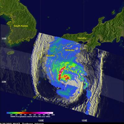
The TRMM satellite had an excellent look at typhoon Jelawat on September 29, 2012 at 1944 UTC. Jelawat had already battered Okinawa with 75kt (~87mph) winds and was headed for the main islands of Japan. An analysis of rainfall from TRMM's Microwave Imager (TMI) and Precipitation Radar (PR) instruments is shown overlaid on an enhanced infrared image from TRMM's Visible and InfraRed Scanner (VIRS). Rain is shown falling at a rate of over 90mm/hr (~3.5 inches) in strong feeder bands northwest of Jelawat's center of circulation. Jelawat was already causing light to moderate rainfall on the
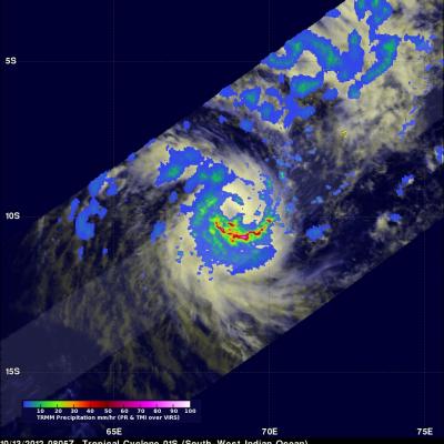
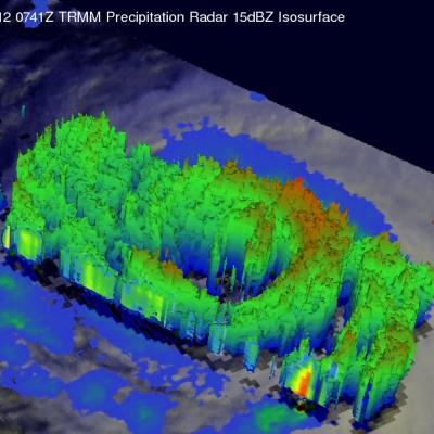
The first tropical cyclone of the 2012 South-West Indian Ocean season called Anais formed northeast of Madagascar yesterday. The TRMM satellite saw Anais on October 13, 2012 at 0805 UTC (~12:05 PM Local). TRMM's Microwave Imager (TMI) and Precipitation Radar (PR) rainfall are shown on the right. Intense bands of rain are shown spiraling around the southern side of the intensifying tropical cyclone. TRMM's Precipitation Radar (PR) data were used to make the 3-D perspective image above. It shows that Anais' had a developing eye wall containing towering thunderstorms reaching an altitude of 15km
The TRMM satellite saw tropical cyclones in three ocean basins today. TRMM flew nearly above tropical storm Patty in the Atlantic Ocean northwest of the Bahamas first on October 12, 2012 at 0326 UTC. It was night so an enhanced infrared image from TRMM's Visible and InfraRed Scanner (VIRS) was overlaid with a rainfall analysis derived from TRMM's Microwave Imager (TMI) and Precipitation Radar (PR) instruments. Patty's location, close to the edge of the TMI swath, is shown with a red tropical storm symbol. TRMM also viewed a developing tropical cyclone in the South-West Indian Ocean on October