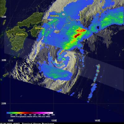
Weakening Typhoon Prapiroon

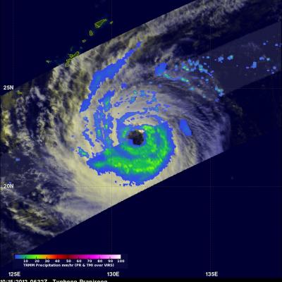
The TRMM satellite again flew above typhoon Prapiroon in the western Pacific Ocean on October 15, 2012 at 0632 UTC. Prapiroon's sustained wind speeds had dropped to 70 kts (~81 mph) with a large and ragged eye being it's dominant feature. TRMM's Microwave Imager (TMI) data indicated that the most intense rain bands south of Prapiroon's eye were dropping rain at a rate of about 30-40 mm/hr (~1.2 to 1.6 inches).

TRMM Sees Prapiroon Near Japan

The TRMM satellite recently had good views of tropical storm Prapiroon when it was passing east of Japan. The TRMM satellite captured data on October 18, 2012 at 0845UTC and again at 1019 UTC. TRMM's Microwave Imager (TMI) and Precipitation Radar (PR) data show that rain associated with Prapiroon was falling at a rate of over 75mm/hr (~3 inches) in a feeder band northwest of the center of circulation. TRMM PR found radar reflectivity values above 50.770 dBz in that area. Some of the rainfall over Japan was being caused by a frontal system that was interacting with tropical storm Prapiroon

Tropical Storm Rafael Getting Stronger

Tropical Storm Rafael Getting Stronger A low pressure center in the eastern Caribbean Sea became tropical storm Rafael on Friday October 12, 2012. The tropical storm wasn't very well organized until today but the National Hurricane Center (NHC) predicts that Rafael will become a hurricane this evening. The TRMM satellite saw most of Rafael on October 15, 2012 at 0218 UTC (10:18 PM EDT October 14) and collected data used in the rainfall analysis on the right.

Hurricane Rafael Shown Passing Near Bermuda

Hurricane Rafael has started to pick up speed after it passed to the east of Bermuda. This image shows a TRMM rainfall analysis that used data collected from two recent passes above Hurricane Rafael. The first orbit was on Tuesday October 16, 2012 at 2250 UTC (6:50 PM EDT). The second orbit received data when TRMM passed over on Wednesday October 17, 2012 at 0028 UTC (8:28 PM EDT on October 16, 2012). TRMM's Microwave Imager (TMI) and Precipitation Radar (PR) data show that Rafael was producing rainfall over a large area of the Atlantic. Bermuda was shown getting light to moderate rain showers

TRMM Sees Sandy As A Hurricane Again

Yesterday Sandy dropped to tropical storm intensity but the National Hurricane Center (NHC) decided on October 27,2012 at 1500 UTC (11 AM EDT) that Sandy was again a minimal hurricane. The rainfall analysis on the right was made from TRMM's Microwave Imager (TMI) and Precipitation Radar (PR) data collected when TRMM flew above less than an hour later at 1552 UTC (11:52 AM EDT). This analysis includes some rainfall that was beyond the reach of land based radar observations.