Tropical Cyclone Emeraude Viewed By GPM

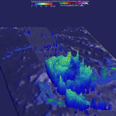
As expected, tropical cyclone Emeraude formed on March 15, 2016 from a tropical low (99s) in the South Indian Ocean. The GPM core observatory satellite flew above intensifying Emeraude on March 16, 2016 at 2121Z after the tropical cyclone's maximum sustained winds had increased to greater than 90 kts (103.5 mph). Rainfall just northwest of Emeraude's eye was measured by GPM's Dual-Frequency Precipitation Radar (DPR) instrument falling at a rate of over 209 mm (8.2 inches) per hour. The powerful thunderstorms producing this extreme rainfall were measured by GPM's radar (DPR) reaching an

GPM Spots Potential South Indian Ocean Tropical Cyclone

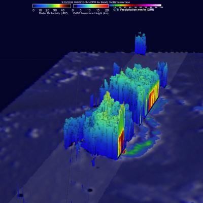
The GPM Core Observatory satellite saw possible tropical cyclone formation in the South Indian ocean on March 15, 2016 at 0900 UTC. A rainfall analysis using data collected by GPM's Microwave Imager (GMI) and Dual-Frequency Precipitation Radar (DPR) shows rain bands wrapping around a tropical low. GPM's DPR measured rain falling at the extreme rate of over 220 mm (8.7 inches) per hour in powerful storms south of the low's center of circulation. GPM's radar (DPR Ku Band) data were able to show the 3-D structure of precipitation within the tropical low. Storm tops heights were measured by GPM
Document Description

This document describes the file naming conventions that will be used to name data products produced by the Precipitation Processing System (PPS) for the Global Precipitation Measurement (GPM) Mission. 

Torrential Rain Over South Measured From Space

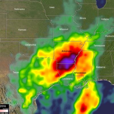
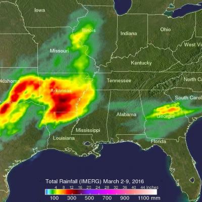
Extremely heavy rain fell over the southern United States during the past week. A slow moving area of low pressure pumped moisture from the Gulf Of Mexico causing torrential rain that resulted in wide spread flooding in states from Texas to Tennessee. Over 24 inches of rain was reported in Monroe, Louisiana. Over 4,958 homes in Louisiana were reportedly damaged by the flooding. Strong winds accompanying intense thunderstorms also toppled trees in Mississippi and Louisiana. A simulated 3-D animation of NASA merged satellite rainfall analysis (TMPA) using data collected from March 7-14, 2016

GPM Views Severe Weather And Heavy Rain in the U.S.

The GPM satellite flew above storms in the southwestern United States this morning (March 9, 2016) at 1011 UTC (5:11 CST). Severe weather has been moving slowly through this area for the past couple days. Two tornadoes developed in north central Texas yesterday morning (March 8, 2016). This morning rain was measured by GPM's Dual-Frequency Precipitation Radar (DPR) instrument falling at the extreme rate of over 148 mm (5.8 inches) in one powerful storm over eastern Texas. GPM's radar (DPR Ku Band) found that a few thunderstorm tops in this area were reaching altitudes above 13.7 km (8.5 miles)