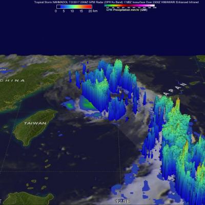
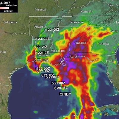
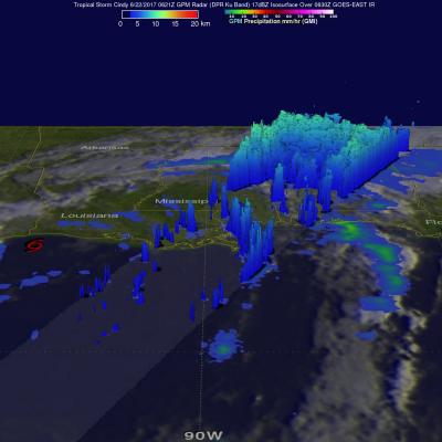
TDRS 171 in safehold: Increased latency on GPM near-realtime products

One of the TDRS satellites which GPM uses for downloading data is currently in safehold. This means that all downloads scheduled for that satellite wiil obviously not be able to be met. This will increase the latency of all GPM NRT products. One missed pass has already occurred and led to increased latency. Several others will occur during the night and into tomorrow.

GPM Views Intensifying Tropical Storm Nanmadol

The GPM core observatory satellite flew above tropical storm NANMADOL on July 2, 2017 at 2306 UTC. The intensifying tropical storm was located just northeast of Taiwan and had maximum winds estimated at 45 kts (51.8 mph). The GPM Core Observatory carries the first space-borne Ku/Ka-band Dual-frequency Precipitation Radar (DPR) and a multi-channel GPM Microwave Imager (GMI). Rainfall within NANMADOL was derived from data collected by GPM's GMI and DPR instruments. Those data indicated that rain was falling at a rate of greater that 184 mm (7.2 inches) per in powerful storms northeast of the

NASA's IMERG Shows Cindy's Extreme Rainfall

Tropical storm Cindy was downgraded to a tropical depression after moving onshore near the Texas and Louisiana Border on Thursday June 22, 2017. Flooding was reported along the the Gulf Coast even before Cindy made landfall. The rainfall around tropical storm Cindy was asymmetrical. The majority of heavy rainfall with the tropical cyclone was located east of Cindy's center in the states along the Gulf Coast from Louisiana through the Florida Panhandle. The tropical depression continued to spread heavy rain and occasionally severe thunderstorms after it came ashore. Severe thunderstorms spawned

V04A IMERG Early GIS friendly products now available

PPS has completed the production of the GIS-friendly TIF/TFW products created from the IMERG Early dataset. These products include running accumulations at 3hr and 1day. The Early TIF/TFW GIS-friendly products have been created back to the beginning of the mission: March 2014. They can be found on jsimpson server in the directories: /NRTPUB/imerg/gis/early/YYYY/MM Documentation for the TIF/TFW products is contained in the document README.GIS.pdf in /NRTPUB/imerg/gis.

GPM Satellite Sees Cindy Drenching Gulf Coast

The GPM core observatory satellite passed above as tropical storm Cindy was approaching the western Louisiana coast on June 22, 2017 at 1:21 AM CDT (0621 UTC). Cindy had maximum sustained winds of about 40 kts (46 mph) at that time. A red tropical storm symbol shows Cindy's approximate location. Rainfall derived from Microwave Imager (GMI) and Dual-Frequency Precipitation Radar (DPR) measurements showed that there was very little rainfall near Cindy's center of circulation but bands of moderate to heavy showers are shown moving into the states along the Gulf Coast. GPM's Radar (DPR Ku Band)